Colorado Daily Snow

By Joel Gratz, Founding Meteorologist Posted 11 years ago February 6, 2013
Yo, yo - check out OpenSnow Pro.
Here are the list of features. Yes, we make some money from advertising but we'd rather improve our forecasts for you than spend time figuring out better advertising techniques. If you enjoy the site, consider upgrading your existing account or signing up for a new one. We'll keep improving both the free and pro sides of the site, so this is just the start. As always, I'd love comments and suggestions: [email protected]
-- Update at 9:45pm --
Well, I should have stuck to the basics. The models all showed great moisture moving through this afternoon and tonight with cooling air and a good wind direction for the central and northern mountains...but low snow accumulations. I went with just a few inches of snow, and it looks like more than that. The Thursday AM report will likely show 4-5" at Copper, Steamboat, Aspen, and maybe a hair more at Vail. That's higher than my 3" high end. So back to basics...models lose this time:-) Enjoy the soft turns tomorrow morning...bet the groomers will be rippin fun with some fluff on top!
-- Update at 6:30pm --
Snow is falling over the mountains (as forecast), and a few spots could see up to 3", maybe 4" around Steamboat and Vail Pass. I can see the end of the snow on radar and satellite, which should be sweeping through later this evening and done before midnight. Might be a few soft turns out there in the morning!
-- Previous discussion at 11:00am --
Lots of images today. Think of it as a pictoral version of The Daily Snow. When there is more to talk about in the short term, I'll post fewer pictures and therefore be able to post earlier in the morning. But on a complicated forecast like this one, I figured you would like to see graphics. The summary is that we'll see a bit of snow today and tonight, then all locations will see snow over the weekend with perhaps more than a foot in the southwestern mountains and also along the front range foothills and slopes east of the divide.
And now for the details...
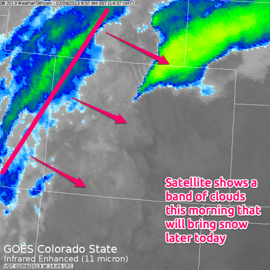
A quick-moving storm will cross Colorado this afternoon and tonight. Here is what it looks like on satellite this morning.
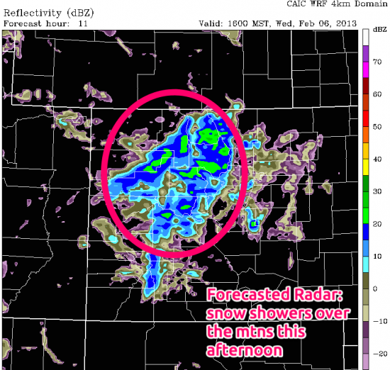
Forecasted radar shows the storm creating snow showers by later this afternoon and tonight for most mountain locations. Expect about 1-2 inches, especially along I-70 and north.
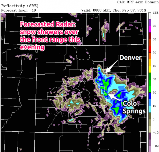
By later this evening, the storm will shift the winds to blow from the northeast and the foothills and plains east of the divide will see a bit of snow while areas west of the divide clear out.
The main event will be the storm this weekend, and we can already see it on satellite as it sits in the Gulf of Alaska. Look closely and you can see two or three swirls within the larger area of the storm. Each of these swirls is an area of maximized vorticity (spin in the atmosphere) and the computer models have to figure out how they play with each other. It's a complicated task, especially since the storm is over the open ocean and there are few on-the-earth weather stations sampling the storm. To fill in the gaps, satellites can measure some variables, but that still requires a lot of interpolation.
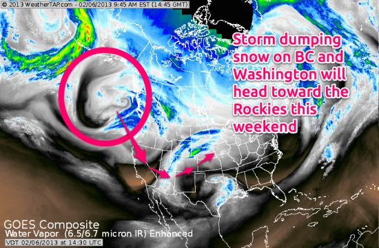
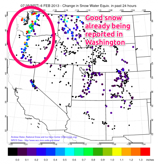
Our future storm is currently pumping moisture into British Columbia and Washington. Respectable snow totals are already showing up in the Pacific Northwest (the graphic below shows the snow water equivalent, not the depth of the new snow).
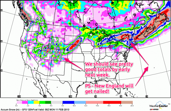
As this storm moves in our direction, models are showing a healthy amount of snow falling over the weekend. But check out New England! They are going to get slammed on Friday into Saturday with some ski areas and especially Boston getting buried in 1-2 FEET of snow (or more?).
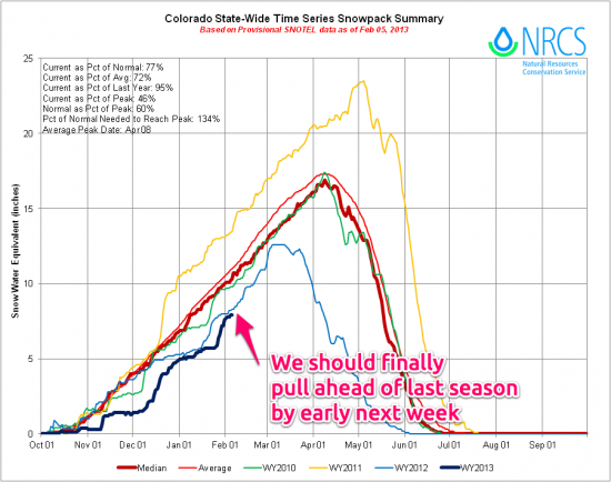
But back to Colorado. After the storm this weekend, we should finally pull ahead of where we were last season. This season is the thick blue line, last season is the thin blue line. We're still about 25% below average, but I think we'll finish up February in a much better position...more on that later:-)
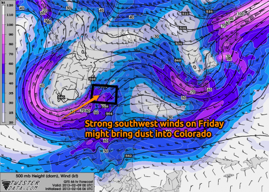
As our weekend storm approaches, there's a chance that it might blow some dust in to the state from the southwest. I expect strong southwesterly winds on Friday, and this is the favored direction for dust to be blown into our state from Arizona and southern Utah. From what I understand, most of this dust comes from soil that has been loosened due to grazing activities. Let's hope there's enough moisture in the soil and the air to supress a dust event. To be clear, I'm not an expert in forecasting dust, so just giving a head's up but not a definitive forecast. Who wants to be called a dust expert anyway? ;-)
On Friday night, the storm will still be to our west. A lead piece of energy might eject to the north and east from the main storm, and this could throw some light snow showers across western Colorado. Overall I expect Friday night to be dry for most areas except for a few inches in the southern San Juans.
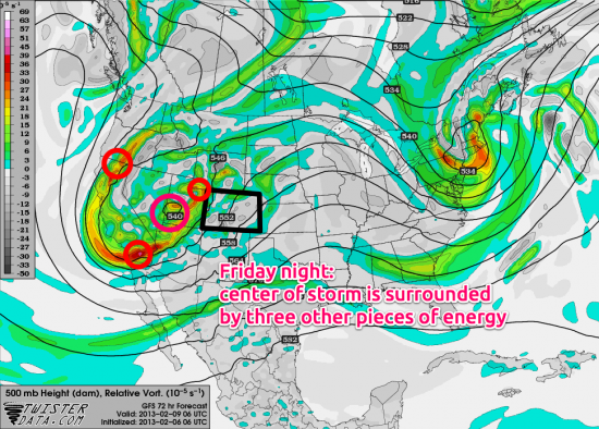
The brunt of the storm should hit on Saturday night. Areas east of the divide should see a nice upslope wind (from the east) and areas west of the divide could see favorable wind directions for snow as well, with good snow falling during Saturday in the southern San Juans and then this heavier snow switching to areas favored by northwest winds later Saturday night, such as Telluride, Monarch, and I-70 northward. In short, Saturday afternoon through Sunday midday is likely the best time for snow. The biggest totals will likely be east of the divide. Click here for the detailed snow forecast.
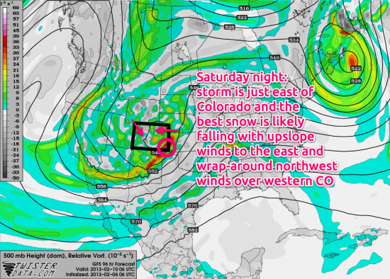
Things get more complicated by Sunday evening. Our storm will have a few distinct pieces of energy all rotating around Colorado. The forecast you see below will NOT be correct. This situation is so complex that I bet the models change many times between now and Sunday. However, the take away is that there will likely be continued periods of at least light snow for Colorado on Sunday as we're caught between the different pieces of this storm.
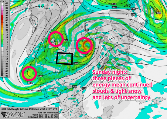
Again, the forecast below for Monday night is likely to change drastically, but right now I'd expect Monday to bring an end to lingering snow showers over Colorado and some clearning coming in by Tuesday.
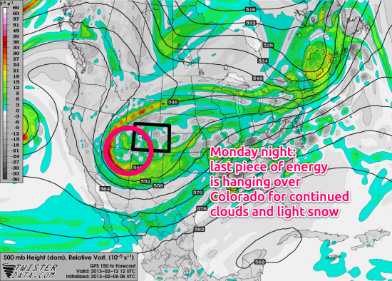
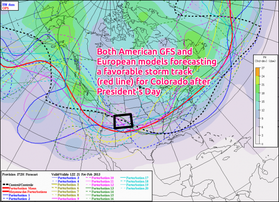
I think next Tuesday and Wednesday (and maybe Thursday) will be dry, then we could see a weak storm move in from the north later on Thursday through perhaps Friday/Saturday. The best news is that both major long-range models agree on a favorable pattern setting up after President's Day. I'm not going to get too excited, but since both models agree and the forecast for the MJO (learn more here) also points toward this scenario, I'm allowing myself some cautious optimism that the last ~10 days of February could be interesting.
Thanks for reading this far! Remember, signing up for a Pro account will help us continue and grow this site. All the features before we launched Pro have NOT changed; we just added things in hopes of earning your money as a snow information source that you enjoy and want to support. I've had some great email conversations with people over the last few days, many of whom had great things to say, and some of whom were unhappy with us changing things up. In all of the "unhappy" cases, it turned out that after discussing our motivation for launching Pro and our vision for the site, the person at least respected and understood our point of view and in some instances the person actually went ahead and signed up for Pro. I love to discuss business models and what you'd like to see in the site, so please email me at [email protected]. Our goal is to provide a service that you like and one that we can make enough money at to both sustain and grow the business. Thanks for helping us to accomplish our goal:-)
JOEL GRATZ
About Our Forecaster


