Colorado Daily Snow

By Joel Gratz, Founding Meteorologist Posted 9 years ago December 17, 2014
Reasons to be excited
Summary:
- Light snow Wednesday & Thursday, just a few inches
- Might be a few surprises, but overall not a big week
- Pattern changes on Sunday with northwest flow through Tuesday
- Likely powder days in northern Colorado early next week
- Another big storm around Christmas?
Details:
There were light accumulations for most mountains on Tuesday through Tuesday evening, and this trend should continue through Thursday. The "storm" that we'll see over the next two days is not that well defined and is more like a blob of moisture passing over Colorado. This will likely yield a few inches of snow on Wednesday and Thursday, but amounts shouldn't be all that impressive.
On Wednesday, the winds will blow from the southwest and west-southwest, and this should favor the central and southern mountains. From Wednesday night through Thursday night, winds will below from the west and west-northwest, and this should favor the central to northern mountains.
While new snow amounts should only be a few inches, the combination of little sun and consistent snowfall could make for some soft and fun conditions on the hill. With a lot of moisture in the air, there could be a few surprises as well.
Friday through midday Saturday will likely be dry and perhaps partly sunny. There's a chance for a few clouds and snow showers over northern Colorado on Saturday, but accumulations should be light to zero.
Then the fun really begins sometime late Saturday night or Sunday and should continue through midday Tuesday. Northwest flow will setup during this time, favoring the mountains along and north of I-70 with consistent and perhaps heavy snowfall. The best combination of cool air and storm energy (vorticity) looks to be around Monday afternoon and Monday night, so I think Monday and Tuesday have the best chance of being powder days.
This is not a sure bet as the flow could push just a bit further to the east and leave us with warmer air and less storm energy. Plus, winds will be very strong during this time, so that could affect the snow surface.
Those negatives aside, I'd keep an eye on early next week as there is a moderate to high chance for a nice powder day or two.
Further south around Aspen and central Colorado, it's too early to know if big snow will make it this far south or stay just a bit to the north.
The precipitation forecast from today through next Tuesday from the American GFS model is promising for the northern mountains, and the forecasts from the Canadian and European models look similar. Multiply by about 14 to estimate snow totals.
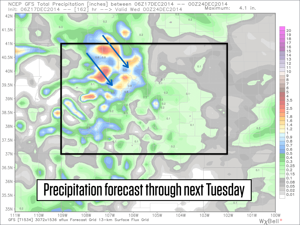
Source: Weatherbell.com
There could be a break or at least a lull in the snowfall next Wednesday, then another wave of energy should move in from the northwest around Christmas Day. This wave will likely again target northern Colorado, though there is a chance that it could move a bit further south and bring snow to central and southern Colorado as well. This latter scenario has a lower chance, but I'm hoping that it materializes so we can even out the snowfall across the state. Right now northern Colorado is sitting around 90% of average while southern Colorado is closer to 60% of average.
JOEL GRATZ
PS - Just a quick request as we head into the holiday season with powder in the forecast. Take an extra second to think about safety. Not just avalanche safety, but even simpler things that apply to in-bounds skiing as well, like skiing with and watching out for friends, wearing a helmet, and staying in control. A reader lost a good friend to a ski accident earlier this month and asked me to pass along this note, and I fully agree with it. We all love to play in the mountains and it would be great if our play led to mostly smiles and very few accidents. Now I'll get off my soapbox:-)
About Our Forecaster
Joel Gratz
Founding Meteorologist
Joel Gratz is the Founding Meteorologist of OpenSnow and has lived in Boulder, Colorado since 2003. Before moving to Colorado, he spent his childhood as a (not very fast) ski racer in eastern Pennsylvania.
Free OpenSnow App


