Colorado Daily Snow

By Joel Gratz, Founding Meteorologist Posted 9 years ago December 18, 2014
Next week should be fun
Summary:
- Light snow continues today into Friday AM
- More light snow possible late Saturday through Sunday AM
- Heavier snow for northern Colorado Sunday afternoon through Tuesday morning
- Another big storm possible right around Christmas Day
- Multiple powder days likely next week ... best Mon, Tue, Thu, Fri
Details:
Snow reports from the last 24 hours show mostly 2-3 inches, so no large surprises. Snowmass came in a bit higher with 4 inches, as did Durango, and Telluride somehow was able to convince the clouds to give up 8 inches, which was a surprise. As I talked about yesterday, a few surprises can happen when there is lots of moisture in the air, so good for Telluride.
Ok, coming up, there's lots to talk about. And it's generally all good news.
Thursday & Thursday night: Light snow will continue, mostly for central and northern Colorado. Look for up to another few inches with mostly cloudy skies. Like yesterday, there is a lot of moisture, so while I'm expecting just light accumulations, there could be a surprise or two. I'm in Albany, NY until Thursday night so I haven't been able to get out on the hill, but I bet a few days of cool weather with light snow has kept conditions in good shape. Can you confirm in the comments?
Friday through Saturday morning: This period looks dry. For the northern mountains I can't rule out a snow shower and lingering clouds, but no big deal.
Saturday afternoon/evening: A weak push of moisture could bring a few more showers to northern Colorado, but accumulations should stay low.
Starting on Saturday night or Sunday through Tuesday: Northwest flow, baby. Lots of moisture, a strong wind from the northwest, and marginal temperatures should combine to produce lots of snow from I-70 and north, with lower amounts south of I-70 to Aspen, Monarch, and the northern San Juans around Telluride and Silverton.
Most weather models are showing the chance of 1-2+ feet of snow for I-70 and north from Sunday through Tuesday morning. I think this is entirely possible because we'll have a ton of moisture in the air (which is the fuel for snow), and we'll also have a wind from the northwest, which is the favored direction for these mountains.
My concern lies in the temperatures, which will be on the warmer side, with readings in the mid 20s (ish) at around 10,000ft. This is warmer than I'd like to see, and sometimes the models can over forecast snow amounts with these warmer readings. However, last year we had a few storms that brought lots of moisture and warmer temperatures, and I downplayed the snow amounts due because I thought the models were biased, and I turned out to be incorrect (it snowed a lot more than I thought and the models were correct). So...I am cautiously optimistic that we're going to crank out a lot of snow in the northern mountains early next week.
Here's the precipitation forecast through Tuesday morning from the high resolution American GFS model. One to two inches of liquid could easily equate to 1-2 feet of snow.
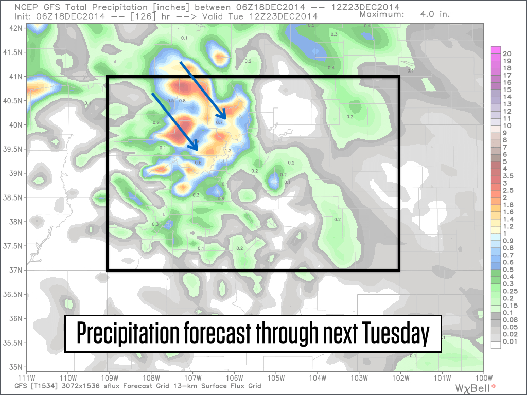
Source: Weatherbell.com
If you're trying to plan your powder days, heavy snow is possible from Sunday through Tuesday morning, and I think the best powder will be on Monday and Tuesday. Tuesday morning's powder might be lighter and fluffier as temperatures should cool Monday night.
Wednesday: Hmm. Not really sure. I think northwest flow will continue to deliver some snow to the central and northern mountains, but I can't offer any more details.
Thursday, Christmas Day: There is growing agreement between the models that we'll see a cold and significant storm on Christmas. The trend has been to push this storm slightly further south, which would ensure that all mountains see snowfall, including the southern San Juans. Temperatures will likely become very cold as this storm rolls through.
Next Friday and the following weekend: I think it'll be drier following the Christmas storm, but hard to pin this down. Friday could be a nice powder day depending on the timing of Thursday's storm.
I hope that this forecast leaves you in a good mood:-)
JOEL GRATZ
About Our Forecaster
Joel Gratz
Founding Meteorologist
Joel Gratz is the Founding Meteorologist of OpenSnow and has lived in Boulder, Colorado since 2003. Before moving to Colorado, he spent his childhood as a (not very fast) ski racer in eastern Pennsylvania.
Free OpenSnow App


