Colorado Daily Snow

By Joel Gratz, Founding Meteorologist Posted 9 years ago December 19, 2014
Oh yeah!
Summary:
- Generally dry Friday & Saturday, perhaps light snow showers north
- Moderate to heavy snow begins in northern mtns late Sat night or Sun AM
- This moderate to heavy snow continues through Tuesday morning
- Another storm should affect the entire state Thursday into Friday
- Total accumulations next 7-10 days should be 2+ feet for northern mtns
- Cold and active pattern lasts through New Years (ish)
Details:
It's 4am and I want to go to bed, but I can't. I'm too excited, so I had to forecast before falling asleep for a few hours. I just returned from Albany, NY where I led two courses that educated first responders and emergency managers about winter weather. That was fun, but man am I glad to be back in Colorado because we're going to have some great snow coming up over the next 7+ days!
Friday: There will be a few fresh inches to ski in the morning in the central and northern mountains, and then aside from linger snow showers in the morning, the rest of the day should be dry with partly cloudy skies and maybe a leftover flurry or shower. This week has been kind to us. Even though most mountains did not see large accumulations on any given day, a few inches per day helps keeps the slopes soft and fun. We'll take it.
Saturday: A tweener type of day. Some clouds around. Some snow showers along and north of I-70, especially in the afternoon. Accumulations should be light.
Saturday night: Snow increases in the mountains from Aspen north to I-70 and Steamboat. Tough to say if it's going to be heavy snow. I do think we'll see some accumulation overnight into Sunday morning.
Sunday through Tuesday morning: Let the games begin! A moist flow from the northwest will drop moderate to heavy snow along and north of I-70. The central mountains around Aspen, Monarch, and Irwin (west of Crested Butte) should do OK, as should the northern San Juans around Telluride and Silverton. Total accumulations during this time could be 1-2 FEET (or more) for I-70 and north and perhaps 5-10 inches in the central/southern mountains that I just listed.
During this period we are going to have a TON of moisture in the air. Moisture is the fuel for snow, and when we have a lot of it, great things can happen. Read: heavy snow and big totals. At the end of January 2014 we had a similar storm where there was a ton of moisture in the air, and many mountains recorded 20+ inches over two days.
The difference between that event and the one coming up is wind direction. In January 2014, the wind was generally from the west, which allowed most mountains to get in on the action. Early next week, the wind will be from the northwest, which favors the mountains along and north of I-70.
In addition to the moisture and a favorable wind direction, the jet stream will be directly overhead, which will help to lift the air and create conditions favorable for heavy snowfall. Here is the jet stream forecast for Monday. The colors show the wind speed in knots, and the red line is my note on the position of the jet stream.
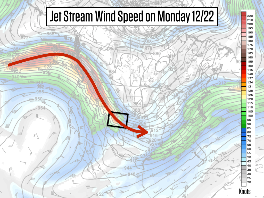
Source: Weatherbell.com
While I am very excited for this storm, there are a few caveats. First, if the track of the jet stream shifts north and east, it could mean less snow. Second, temperatures will be somewhat warm, in the low to mid 20s around 10,000ft. This is OK for big accumulations, but it's not ideal. Due to the warmer temperatures, the snow could be a bit thicker than we'd like, but I thought this same thing during the January 2014 storm and the snow turned out to be blower for part of the storm, so we'll see. The warmer temperatures could also mean that elevations below perhaps 7,500ft could actually see rain. Most of our skiable terrain is over this elevation, so not a bit concern on the hill, but perhaps for base areas and other valley locations.
Colder air should arrive Monday night into Tuesday morning, so Tuesday morning *might* be the best powder day as we will have lots of fresh snow already on the ground, and then the snow on Monday night and Tuesday morning should be lighter and fluffier. Fluffy snow on top of denser, thicker snow is called a right-side-up storm. Hoping this transpires as it can ski super well since the thicker snow makes the base soft and supportive and the top layer of the snow is in-your-face blower. I'm trying not to get too excited because things can go wrong with this forecast. But man, I am excited. You can probably tell...
Tuesday evening through Wednesday: I think we'll see lighter snow during this time, but the accumulations could keep coming for northern Colorado.
Thursday into next Friday: There is decent certainty that most mountains will see a significant and colder storm right around Christmas. The details are still murky. The central and northern mountains should once again see the most snow, but the southern San Juans should be able to eek out some snow especially if the storm drops just a bit further south.
Next weekend, December 27-28: Umm, more snow? Yup. The weather pattern looks cool with continued chances for snow. This is too far out to offer any details, but the western US looks active through this weekend and up until at least New Years.
I never look at the details of the 10-day precipitation forecast because 240 hours is too far out to forecast with much certainty. But when I see all three major models (American GFS, Canadian GEM, European ECMWF) point to 3-4 inches of liquid equivalent (3++ feet of snow), I can't ignore it and I just feel like jumping up and down. The graphic below is the high resolution American GFS model forecast for precipitation through Sunday December 28th. You can see that northern and central Colorado is favored. Multiply by about 15ish to estimate snowfall.
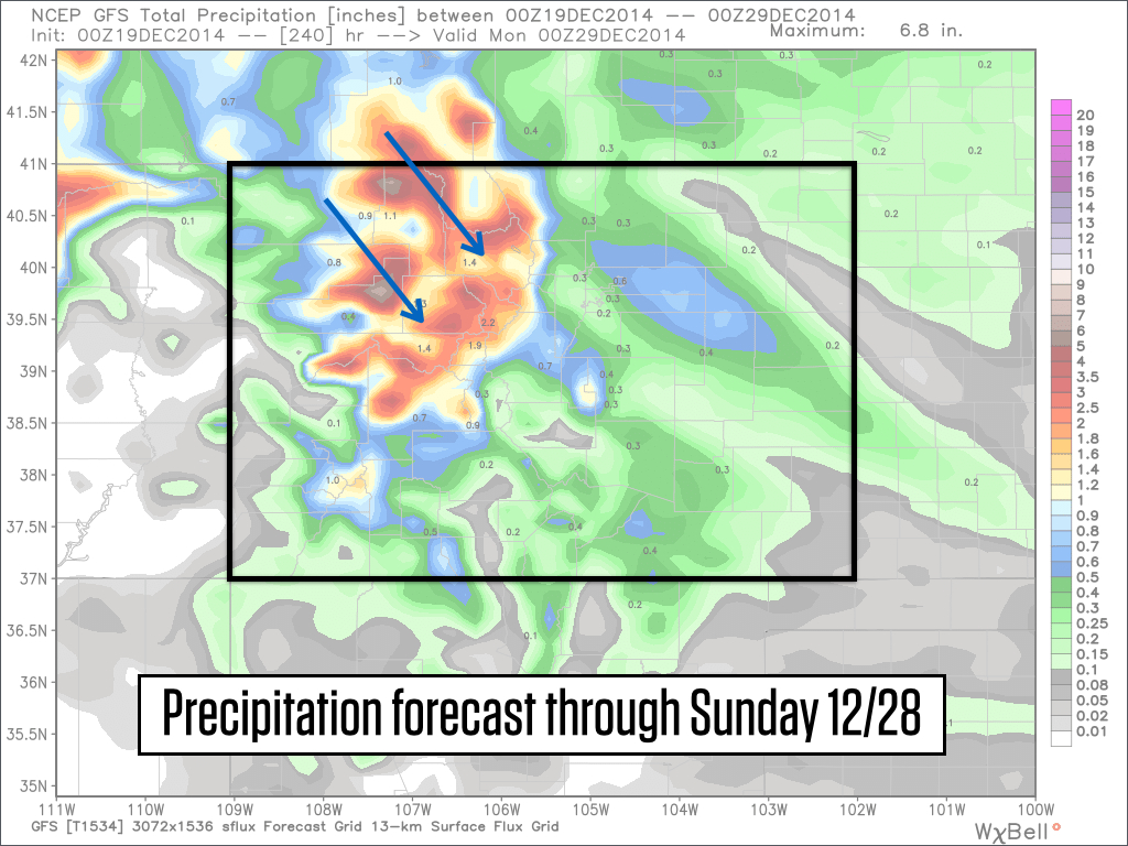
Source: Weatherbell.com
In short, there's plenty to be excited about over the next 10 days, but keep your optimism in check as the atmosphere usually offers a few surprises, some bad, and some good. Ah, the heck with it. Go ahead and get excited. If you're a local, these forecasts reaffirm why we love this place. If you're visiting for the holidays, nice timing!
Ok, that's it for now. You just read 1,000 words about weather. Well done, snow lover, well done:-)
JOEL GRATZ
PS - I did pick a winner for the Wagner Custom Skis giveaway and I did notify this person. If she is OK with it, I'll publish her name in the next few days. Thanks for entering and sorry that you didn't win. We'll have more contests coming up this season.
PPS - We are launching a new way to support OpenSnow and get a few additional features & discounts. It's called the OpenSnow All-Access Pass and it's only $19/year and replaces our Pro ($20) and SuperPro ($45) memberships. It's less money than our previous packages, and provides $10 discounts to both Liftopia and skis.com, so the benefits are worth more than the price of the subscription. Thanks for checking it out: http://opsw.co/1wrOOOb
About Our Forecaster
Joel Gratz
Founding Meteorologist
Joel Gratz is the Founding Meteorologist of OpenSnow and has lived in Boulder, Colorado since 2003. Before moving to Colorado, he spent his childhood as a (not very fast) ski racer in eastern Pennsylvania.
Free OpenSnow App


