Colorado Daily Snow

By Joel Gratz, Founding Meteorologist Posted 9 years ago January 25, 2015
Two weak systems this week
Summary:
- Leftover clouds and flurries Sunday morning in northern Colorado
- Monday will be sunny and super warm
- Weak storm brings some snow Wednesday
- Another weak system for Saturday-ish
- Weather pattern will be unfavorable for consistent cold/snow through early Feb
Details:
A storm gave a glancing blow to the northern mountains on Saturday and Saturday night, bringing clouds on Saturday and then a few snow showers Saturday night. The mountains along the divide generally saw the only accumulations, with about 1 inch at Abasin, Loveland, Keystone, and Winter Park.
Sunday: Clouds will continue to impact the northern mountains, though I'm not expecting any additional snow accumulations and maybe just a few flurries. The satellite image shows the moisture/clouds arcing north into Canada, over the ridge of high pressure, and then south along and east of the spine of the Rocky Mountains. The moisture that is moving south from Canada is what's impacting our northern mountains.
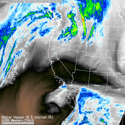
A 2.5 hour water vapor satellite image ending at 630am on Sunday. Source: Weathertap.com
Monday: Sunny and very warm. On-mountain temperatures will be in the 40s, which is very warm for this time of year. Spring break 2015 is coming early!
Tuesday: Likely dry and still warm, though not as warm as Monday. Some clouds will spread over the state during the midday and afternoon hours as a weak storm pushes moisture northward from Mexico.
Wednesday: This weak storm from Mexico will be over Utah/Wyoming on Tuesday night and will push east across Colorado on Wednesday. It'll have lots of moisture, but weak energy to lift the air and help create snow, plus temperatures will be warm with snow levels around 8,000-9,000ft. This all combines into a forecast for a few inches of snow, especially for the northern half of the state. With so much moisture in the air, there could be higher-than-expected snowfall amounts if the storm is a bit stronger than forecast. But with the warm air and forecast for weak storm energy, I'll keep snow projections on the lower side.
Thursday: Likely dry with high temperatures in the upper 20s to low 30s.
Friday through next Sunday: Another weak storm from Mexico might sneak northward through the ridge of high pressure. If this storm stays further south, there will be little to no snow for Colorado. If this storm pushes further north and combines with a system that will drop south from Canada, then there could be decent snow across the state. At this point, let's just say that we'll likely see some flakes in the state sometime between Friday night and Sunday morning, though I'm going to keep my expectations for this storm on the low side since the overall weather pattern isn't favorable for cold air and snow for most of the state. If we can eek out heavier snowfall, it'll be a lucky break.
Overall weather pattern: It looks like the pattern of cold air in the eastern US and warm air in the west will not break anytime within the next 10-15 days. While we could see weak storms push through the western high-pressure ridge and bring us some precipitation, as the forecast below shows, the current pattern isn't going to move anytime soon. That said, I do want to remind folks that most of our ski areas are 100% open, so even though there is not much snow in the forecast, there is still plenty of terrain to ski.
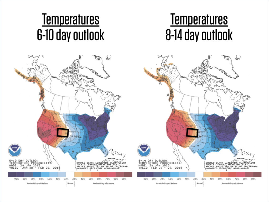
Source: NOAA
If you're still gettin' out there and enjoying the snow, post some pictures in the comments. Or if you want to share some powder pictures from earlier this season or previous seasons, post those in the comments as well and keep the positive thoughts going:-)
JOEL GRATZ
PS - The 13th Annual Beacon Bowl & Après Party will take place at Arapahoe Basin Ski Area on Saturday, February 7, 2015. The Beacon Bowl is a full day of beacon search competitions, avalanche dog demos, and a sweet après party with deals on pizza and beer, raffles and a huge silent auction. You already know A-Basin throws one heck of a party, but it’s even better when it’s for a good cause – all proceeds benefit the Colorado Avalanche Information Center (CAIC), the team who forecasts backcountry weather and avalanche danger for the entire state. Come on up to the Basin on February 7 to party with a purpose! To learn more or to donate to the CAIC, go to http://opsw.co/1t5VYYp
About Our Forecaster
Joel Gratz
Founding Meteorologist
Joel Gratz is the Founding Meteorologist of OpenSnow and has lived in Boulder, Colorado since 2003. Before moving to Colorado, he spent his childhood as a (not very fast) ski racer in eastern Pennsylvania.
Free OpenSnow App


