Colorado Daily Snow

By Joel Gratz, Founding Meteorologist Posted 9 years ago February 1, 2015
Northern snow Monday through Wednesday
Summary:
- Dry on Sunday
- Snow for northern mountains Sunday night through Wednesday night
- Likely light accumulations each day & night
- Wednesday has the best chance to be a powder day
- Thursday, Friday, and Saturday will be dry and warm
- Slight pattern shift after that, but not sure if it'll lead to more snow
Details:
Saturday's storm worked out decently. Most ski areas received 2-3 inches, with a few reporting 4 inches. The storm cleared out of the southern mountains earlier than I thought with only 1-2 inches falling there. On Saturday night, the storm from the northwest did setup a few potent bands of snow from about Eldora north to Rocky Mountain NP and Cameron Pass. I saw reports of 5-8 inches from Boulder south to Denver as those bands moved over the plains, but I couldn't find much data from the mountains to see how much snow fell north and west of Boulder.
Temperatures cooled nicely on Saturday night, and readings on Sunday morning are in the upper single digits and teens throughout most of the state.
Sunday: Dry, mostly sunny, and cooler than the past few days with highs around 20-25F.
Sunday night through Wednesday night: Moisture from the northwest will stream over northern Colorado during this time. That's a good thing. Also, waves of upper-level energy will move over northern Colorado, and this too is a good thing. The factors working against heavier snowfall will be steady or slightly warming temperatures, and also a wind from the west instead of the northwest (this west wind is OK for some areas, while northwest is better for others).
So what does this mean for snow? For the mountains along and north of I-70, flakes should be in the air from Sunday night through Thursday morning. The timing of heavier snow could be Sunday night into Monday midday, Monday night into Tuesday morning, and Tuesday night through Wednesday evening. That said, it is difficult or impossible to accurately predict the timing of each wave of heavier snow as the models have trouble picking up the details of each wave of energy as it moves through.
In terms of snow amounts, I'm only forecasting a few inches during each day and night period. A bit more for Steamboat being further north, and also because the cold air in the Yampa Valley might help to lift the incoming moist air and create more snow, especially earlier in this storm. I also forecasted a bit more for Loveland, Abasin, and Breckenridge which seem to do a bit better during storms with a warmer, moist wind from the west.
The best powder day of the next week could be Wednesday. Most models agree that the strongest piece of energy and heavier snow will move through Tuesday night and Wednesday. Also, if we can get snow to fall Sunday night through Tuesday, the base might soften enough for Wednesday's heavier snow to act as a nice top layer of powder.
The caveat here is that the setup from Sunday night through Wednesday is not ideal. Our northern mountains will be on the southern edge of the storm track, and temperatures will not be cooling during the storm. These two factors make me want to urge caution about getting very excited for this storm. But with the lack of consistent snow over the last month, any snow is good snow.
As the map below shows, the heaviest snow will be along and north of I-70, with much lighter amounts south of I-70 in the central mountains, and likely no snow in the San Juans (unless a stronger wave of energy brings snow to the northern San Juans. Multiply the numbers on the map by about 12 to estimate snowfall.
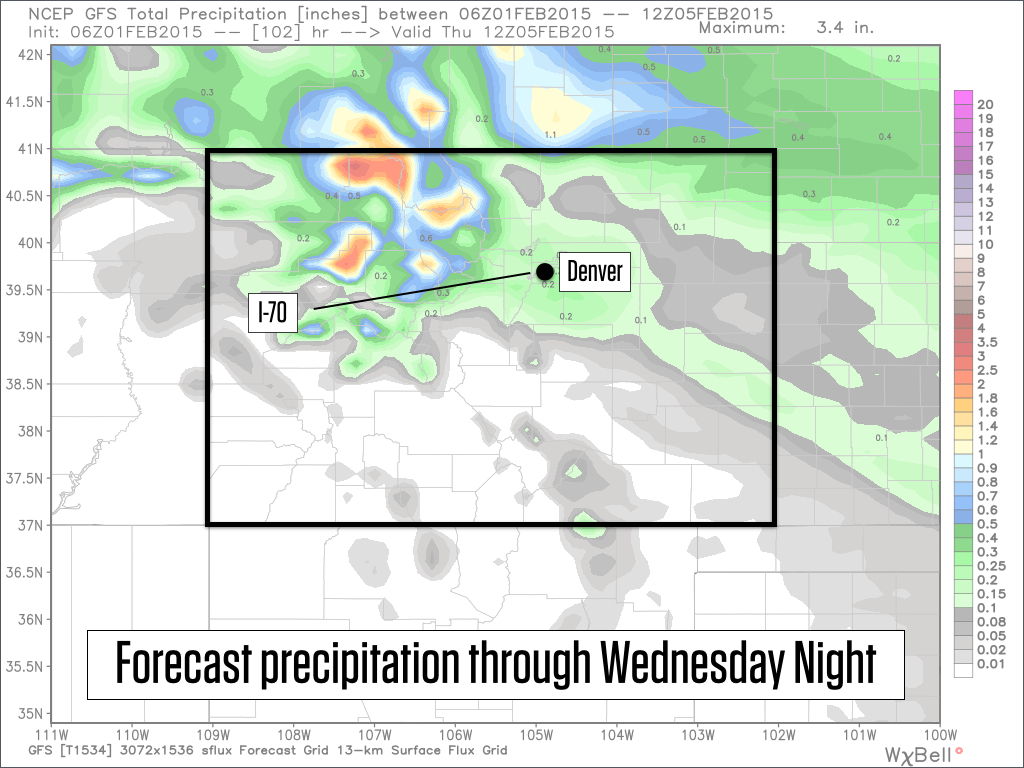
From the American GFS model. Source:Weatherbell.com
Thursday, Friday, Saturday: Snow should end for the northern mountains on Thursday morning, then the rest of Thursday, Friday, and Saturday will be dry, sunny, and warm.
Saturday night through Tuesday, February 10th: The ridge over the west coast will hang tough, but two storms could push through or over the ridge and might bring lighter snow to our northern mountains on Saturday night or Sunday, and again around Tuesday, February 10th. I don't see either of these storms as a big deal, but I'll keep watching.
Longer range: Broken record. The ridge of warm and drier weather will continue over the west, and a trough of cooler and snowier weather will hang tough over the eastern US. That said, some of the models show the western ridge pushing west about 10-15 days from now. If this happens, we would have a better chance of seeing storms go over the ridge and drop down into Colorado. It is way too early to get excited about this scenario because 1) it might not happen, and 2) even if it does, this shift might not be enough to bring consistent cold and snow back to Colorado. Something to watch for, though.
JOEL GRATZ
Announcements:
- Win a pair of Hestra Heli Gloves! Enter here: http://opsw.co/os-contest
- In case you missed the announcement, we added Canadian mountains and improved our forecast data. Details here: http://opensnow.com/news/post/new-features-canadian-mountains-added-forecast-data-improved
- Learn about where to find the best powder in Dr. Steenburgh's new book. My review: http://opsw.co/15KTdSk
About Our Forecaster
Joel Gratz
Founding Meteorologist
Joel Gratz is the Founding Meteorologist of OpenSnow and has lived in Boulder, Colorado since 2003. Before moving to Colorado, he spent his childhood as a (not very fast) ski racer in eastern Pennsylvania.
Free OpenSnow App


