Colorado Daily Snow

By Joel Gratz, Founding Meteorologist Posted 9 years ago February 18, 2015
Weekend powder is a good bet
Summary:
- Dry Wednesday and Thursday
- Snow from Friday through Sunday
- Initial storm thoughts...
- East of the divide: best powder Sat & Sun, 10-20"
- Northern & central mountains: best powder Saturday, 6-10"
- Southern mountains: most uncertainty
- Dry early next week, more snow late next week or next weekend
Details:
I have good news for this upcoming weekend and the longer-range outlook! Let's get to it...
Wednesday & Thursday: Mostly sunny and dry. A few clouds will linger over the northern mountains for part of Wednesday. Temperatures will be in the 20s and low 30s on Wednesday, and the low-to-mid 30s on Thursday.
Friday through Saturday: The first wave of snow will push through during this time. The storm will come from the north-northwest, similar to this past weekend's storm, but with a few slight differences.
For the northern and central mountains (Wyoming south to about Aspen), look for a couple of inches to accumulate on Friday midday through afternoon, and more snow, likely heavier, on Friday night through Saturday morning. Saturday could be a nice powder day, with 6-10 inches on the ground for the northern mountains and maybe similar or slightly lower amounts in the central mountains.
For areas east of the divide, you'll likely be the winner once again, just like the previous storm. Snow should fall heavily Friday night, with Saturday likely being a powder day, skiing on double-digit snow totals.
The trickier forecast is for the southern mountains. I think Telluride and Silverton will pick up a couple of inches with this first wave on Friday night into Saturday morning, while Durango and Wolf Creek stay on the drier side.
Saturday night through Sunday night: A second wave of snow should push through the state, though it'll likely be a bit weaker than the first wave.
For the northern and central mountains, I have another few inches in the forecast during this time. Just like the last storm, most mountains might see relatively low accumulations with one or two locations getting lucky and finding themselves under a band of heavier snow. Sunday will be a nice day on the hill with leftovers and soft conditions. If more significant snow falls Saturday night and/or Sunday, than Sunday could be the best powder day of the weekend since multiple days of snow will have created a soft base. That said, I have lower confidence in snow amounts on Sunday.
For the southern mountains, this is once again a tricky forecast. The European and British weather models show this second wave of snow having a low impact for the south with perhaps 3-6 inches of additional snowfall (more at Wolf Creek). The American and Canadian models show this second wave of snow pushing much further south with much larger snow totals and a likely Sunday/Monday powder day. I'll side with the typically more accurate Euro/Brit models right now, and forecast lower snow totals, but this prediction is far from locked in.
Here's an updated precipitation forecast map for the full storm, from Friday through Sunday. Multiply by about 13,14, or 15 to estimate snow totals.
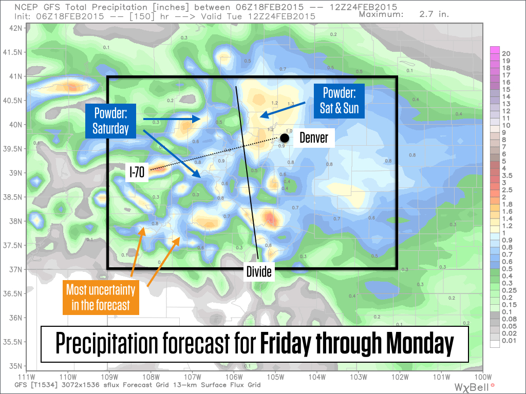
Source: Weatherbell.com
The summary for this weekend's storm is that both Saturday and Sunday should offer fresh snow, and the deepest snow totals will be east of the divide. There are still large differences between all of the model forecasts, so be sure to check back on Thursday and Friday as I update the forecast. Some things WILL change!
Monday through next Wednesday: Likely dry and a bit warmer than the weekend, though high temperatures will likely stay cool in the 20s, somewhat (but not completely) countering the higher sun angle of late February.
Longer range outlook: Things are looking up. The pattern shift may finally move toward a full-on pattern change.
The graphic below shows forecasts for 5 time periods in the future, out to 10 days.
This Thursday, seen in the top panel, the ridge over the west (red line) is hanging on while the trough over the east will persist (blue line). Over the weekend, the east-coast trough pushes west over Colorado which will bring us snow, but then by early next week on Tuesday 2/24, the familiar pattern reestablishes itself with a ridge over the west and a trough over the east.
The good news, though, is that all of the models show this entire pattern pushing west as we get closer to March. The bottom two panels clearly show the trough shifting west toward the west coast, and a weak ridge developing over the eastern US.
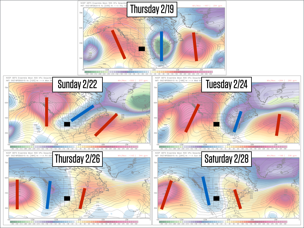
Source: Weatherbell.com
What does all of this mean for snow in Colorado (and the western US and Canada, in general)? A trough over the west would be good news, and while it wouldn't guarantee powder days for Colorado, the western US, and western Canada, it certainly would improve their odds.
The big caveat to this is that we're still 10+ days from this pattern shift, and some of the articles I've been reading about the longer range outlook hint toward the models being a bit over zealous about shifting the pattern. So maybe it won't happen quite as quickly as the above graphics illustrate.
The take-home concept about the long-range outlook is that we likely WON'T have a persistent strong ridge of high pressure over the west coast as we head into March, and this improves our odds of seeing colder weather and consistent snow.
JOEL GRATZ
About Our Forecaster
Joel Gratz
Founding Meteorologist
Joel Gratz is the Founding Meteorologist of OpenSnow and has lived in Boulder, Colorado since 2003. Before moving to Colorado, he spent his childhood as a (not very fast) ski racer in eastern Pennsylvania.
Free OpenSnow App


