Colorado Daily Snow

By Joel Gratz, Founding Meteorologist Posted 9 years ago February 27, 2015
Five more days of snow
Summary:
- Friday-AM pow for a few spots
- Snow from Friday night through next Wednesday
- Heaviest snow in southern mountains
- Moderate snow in central mountains
- Lighter snow in northern mountains
- Temperatures will be rather warm over the weekend
- Colder air and northwest winds next Tue/Wed favor northern mountains
- Dry March 5-8 (perhaps longer?)
Details:
Thursday night's forecast worked out pretty well with most areas seeing a few inches of snow from Thursday afternoon through Friday morning. Wolf Creek did do well, as expected, with 6 inches. The surprise was along a narrow area of the western I-70 corridor where Vail, Beaver Creek, and Sunlight nabbed 7-8 inches overnight. Lucky!
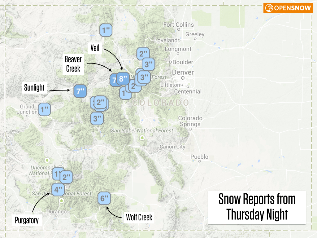
Source: OpenSnow.com Powder Finder
Friday:
This is a transition day. Thursday night's system will weaken and move away, though a few snow showers could still fall in central and southern Colorado during the day. By the afternoon and evening, winds will blow from the southwest, and this will get the snow to ramp up for the southern mountains.
Friday night through Monday:
Winds will blow from the southwest during this entire time, so the heaviest snow will fall in the southern mountains. It won't snow hard the entire time as there will be some lulls, but overall expect heavy snow. Also, there will likely be two times during this period that some upper-level energy associated with the jet stream pushes a band of heavier snow into the central and northern mountains. It's hard to figure out the exact timing of this, but I think one of these bands could push north Saturday afternoon and evening, and another band could do the same thing on Sunday night into Monday.
Overall, I expect 2-4 feet of snow in the southern mountains, perhaps 1-2 feet in the central mountains, and likely a foot or less in the northern mountains. Also, temperatures will be rather warm over the weekend with the moist winds blowing from the southwest, so expect higher-density snow. Likely not blower powder.
Here's the setup for the weekend based on a map of temperature and wind at about 10,000 feet.
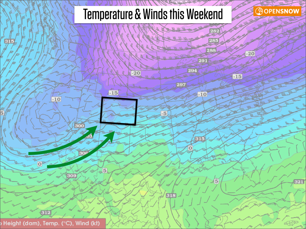
Source: Twisterdata.com
Next Tuesday and Wednesday:
The weather pattern will gradually shift east, allowing colder air to move in from the northwest. There are still some differences between the models about when the colder air moves in, so I can't nail this down right now. The general idea is that there will still be snow falling on all mountains during this time, and the northern and central mountains should have a better chance of seeing deeper powder. Again, the setup using the wind and temperature map at 10,000 feet.
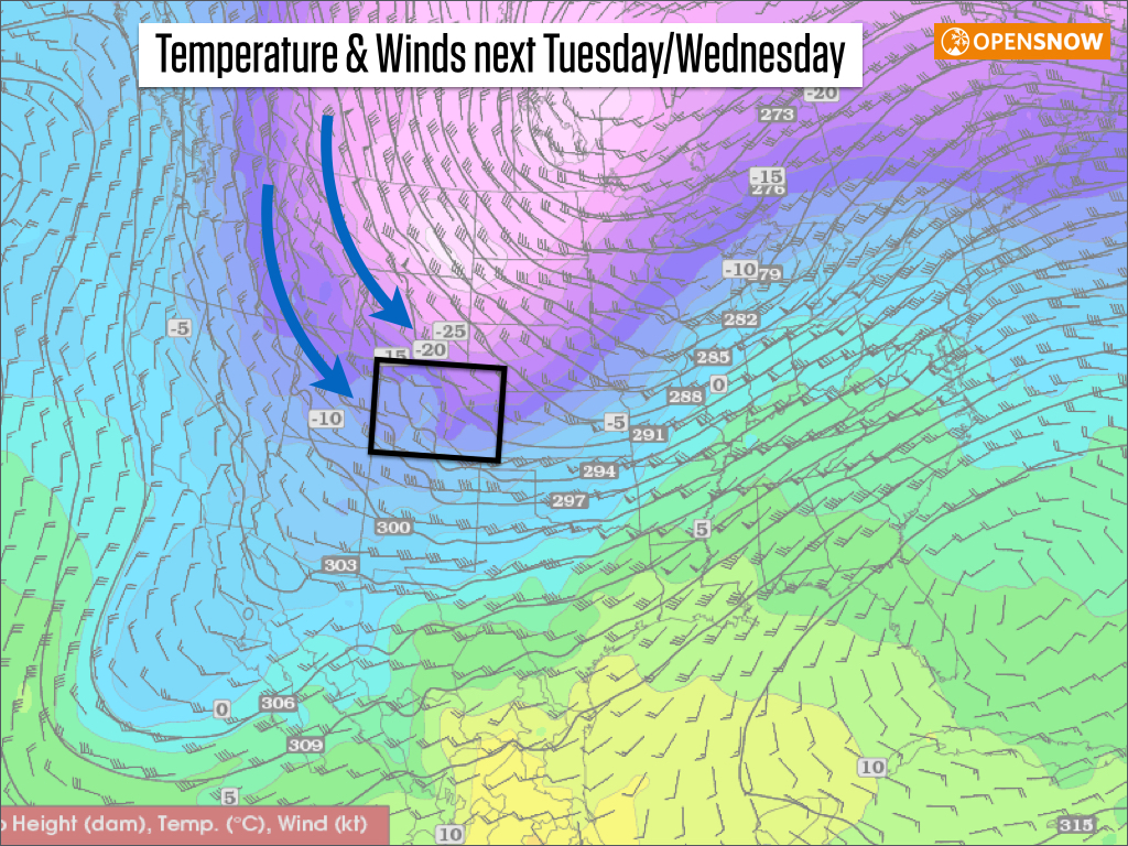
Source: Twisterdata.com
March 5-8th:
The end of next week and next weekend looks dry, and this dry weather might extend a few days after the 8th, perhaps through the 10th. There is no consensus in the mid-range models about what happens after about the 10th, so we'll have to wait at least another few days before trends emerge in the models.
JOEL GRATZ
-----
Contest!
We're giving away a ski jacket from the company NWT3K. The cool part is that you can customize the jacket's colors and zipper layout. Click here to enter the contest: http://opensnow.com/contest
-----
Geography Key:
Northern Mountains
Steamboat, Granby, Beaver Creek, Vail, Ski Cooper, Copper, Breckenridge, Keystone, Loveland, Abasin, Winter Park, Berthoud Pass, Eldora, Rocky Mountain National Park, Cameron Pass
Along the Divide
Loveland, Abasin, Winter Park, Berthoud Pass
East of the Divide
Eldora, Rocky Mountain National Park, Cameron Pass
Central Mountains
Aspen, Sunlight, Monarch, Crested Butte, Irwin, Powderhorn
Southern Mountains
Telluride, Silverton, Durango, Wolf Creek
About Our Forecaster
Joel Gratz
Founding Meteorologist
Joel Gratz is the Founding Meteorologist of OpenSnow and has lived in Boulder, Colorado since 2003. Before moving to Colorado, he spent his childhood as a (not very fast) ski racer in eastern Pennsylvania.
Free OpenSnow App


