Colorado Daily Snow

By Joel Gratz, Founding Meteorologist Posted 9 years ago February 28, 2015
More confidence in the timing of the heavier snow
Summary:
- Snow for Colorado every day from Saturday through Wednesday
- Heaviest snow Sat PM, then Sun PM through Wed
- Deepest accumulations likely in the southern mountains
- Central and northern mountains will also see their fair share of snow
- Dry weather starting on Thursday March 5th, continuing for at least 5 days
Details:
We did not see a lot of new snow on Friday night. The heaviest snow stayed just south of Colorado, targeting northern New Mexico (12 inches on Friday night at Taos, 20 inches between Friday AM and Saturday AM!). The radar image below shows generally where the snow is falling. I use the word "generally" because radar isn't a perfect tool in mountainous areas. You can see the heavier snow in New Mexico, Arizona, and southern Utah, and this snow should make its way north into southern Colorado by early in the day on Saturday.
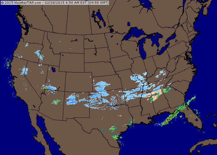
Source: Weathertap.com
Snow will be in the air from Saturday through Wednesday. During this time, there will be multiple waves of heavier snowfall.
The easy part of the forecast is to say that there will be accumulating snow each day from today, Saturday, through Wednesday. It's also a relatively good bet that the deepest accumulations will fall in the southern mountains from Saturday through Monday due to winds from the southwest, and then accumulations will likely favor the central and northern mountains (and perhaps the north side of the southern mountains) from Monday evening through Wednesday as the winds switch to blow from the west and northwest.
The harder part of the forecast is to figure out the timing of the waves of heavier snowfall and the timing of the lulls. There is not a lot of consensus between the six models that I look at (American GFS, European ECMWF, British UKMet, Canadian CMC, American NAM12km, American NAM4km), so that isn't much use.
However, I did find a signal in the SREF model, which combines 21 American-based models into a system where it's easy to see the probabilities and range of certain variables.
Below is a graph of the precipitation forecast for each 6-hour period at Telluride. While the amount of precipitation changes at different stations around Colorado, the timing of the heaviest precipitation is rather consistent, so using Telluride's forecast as a proxy for most of Colorado's mountains is a decent method at this early point in the storm.
The green line shows the average of all the forecast models, while bars show the highest and lowest values. Yes, there is a considerable range between the highest and lowest forecasts, but there is a pretty nice signal that shows the potential for heavier snow from Saturday afternoon through Saturday night, then a lull on Sunday, with snow picking back up from from Sunday night through Tuesday. The numbers are in liquid equivalent, so multiply by about 13 to estimate snowfall.
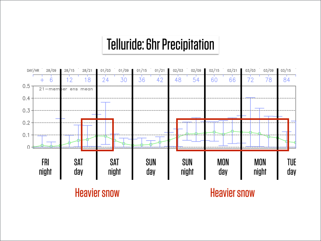
Source: Weatherbell.com
That was my main forecast challenge for today, the timing of the heavier waves of snow. With the above trend in mind, I tweaked the snow forecast numbers, which you can find here: http://opensnow.com/state/co.
Also, we just created pages that show the forecast for all mountains that are included in certain groups, like the mountains under the Mountain Collective pass, the Rocky Mountain Super Pass, and the Epic Pass. You can see links for these pages near the top of our forecast page (http://opensnow.com/forecasts), and please email me ([email protected]) with other groupings you'd like to see.
With a soft base due to all the recent snow, and additional snow in the forecast, conditions are going to be pretty darn good during the next five days. I hope you can get out and enjoy!
Wednesday night through March 10th:
This period looks to be dry across most of the western US, including Colorado. I don't see a clear trend in the forecast after this time, so I can't say anything about when the snow will return. With this in mind, don't waste the opportunity to ski/ride during the next couple of days!
JOEL GRATZ
-----
Geography Key:
Northern Mountains
Steamboat, Granby, Beaver Creek, Vail, Ski Cooper, Copper, Breckenridge, Keystone, Loveland, Abasin, Winter Park, Berthoud Pass, Eldora, Rocky Mountain National Park, Cameron Pass
Along the Divide
Loveland, Abasin, Winter Park, Berthoud Pass
East of the Divide
Eldora, Rocky Mountain National Park, Cameron Pass
Central Mountains
Aspen, Sunlight, Monarch, Crested Butte, Irwin, Powderhorn
Southern Mountains
Telluride, Silverton, Durango, Wolf Creek (Telluride and Silverton are on the northern side of the southern mountains)
About Our Forecaster
Joel Gratz
Founding Meteorologist
Joel Gratz is the Founding Meteorologist of OpenSnow and has lived in Boulder, Colorado since 2003. Before moving to Colorado, he spent his childhood as a (not very fast) ski racer in eastern Pennsylvania.
Free OpenSnow App


