Colorado Daily Snow

By Joel Gratz, Founding Meteorologist Posted 9 years ago March 1, 2015
And the storm continues...
Summary:
- Snow will fall from Sunday through Wednesday midday
- Heaviest snow on Sun & Mon in southern & central mountains
- Heaviest snow on Monday PM through Tuesday in northern & central mountains
- Dry weather from Wednesday night (March 4) through at least Tuesday March 10th
Details:
I am writing this update before most ski areas publish their snow report on Sunday morning, so I can't be certain about the snow totals over the past 24 hours. Based on snow-stake cams, though, it looks like 3-5 inches fell on the northern mountains, about 6-12 inches accumulated in the central mountains (about a foot on the pow cam at Crested Butte), and something like 8-16 inches in the southern mountains (Telluride looks like about 12 inches, with half on Saturday and half on Saturday night). All of these numbers are about in line what we've been talking about as southwest winds favor the southern mountains and then progressively less snow falls as you move north through the state. If you're keeping score, Taos is likely the winner of round one with a report of 21 inches on Saturday morning plus another 10-15+ (?) inches on Saturday and Saturday night.
The numbers above reflect only the initial part of this storm. There is still plenty of moisture and energy heading toward Colorado over the next three days.
The radar image below shows plenty of snow and rain over southern California and Arizona, continuing to stream into Colorado from the southwest.
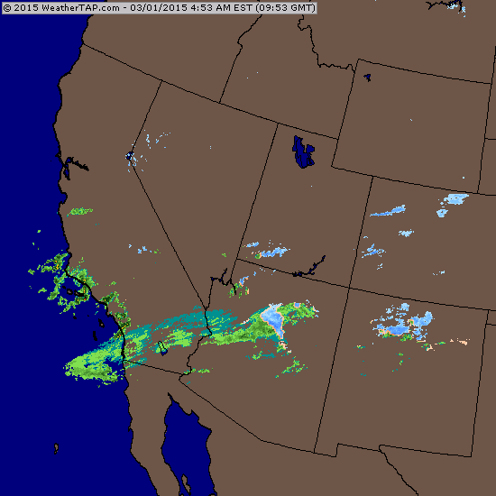
Source: Weathertap.com
The satellite image from Sunday morning shows a plume of clouds extending from Colorado all the way back into the Pacific Ocean, southwest of California, as the center of the storm swirls just off the central California coastline. Just like the radar image above, this indicates that there is plenty of additional snow on the way!
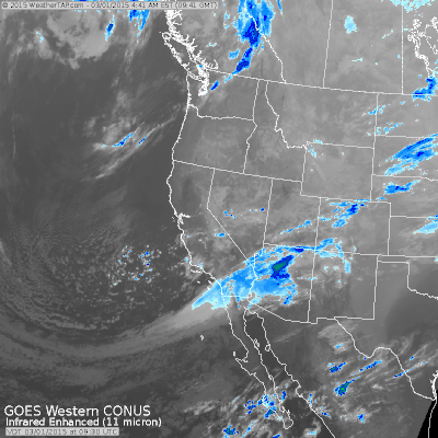
Source: Weathertap.com
Sunday through midday Monday:
Winds from the southwest will continue to pump moisture into Colorado. Look for additional snowfall, with the highest totals in the southern mountains, moderate totals in the central mountains, and lower amounts in the northern mountains. There could be a lull in the snow on Sunday morning, but don't worry as this lull won't last for long.
Monday night through Wednesday:
A band of moderate to heavy snow should push across Colorado from west-to-east on Monday afternoon and Monday night. This band of snow should drop a quick ~6 inches on most mountains. And then on Tuesday, the winds will change direction and blow from the west and northwest. This is a more favorable direction for the northern and central mountains, as well as Telluride and Silverton in the southern mountains. Most of these locations should see times of moderate to heavy snow showers on Tuesday with another ~6 inches of snow accumulating. Tuesday afternoon might offer the best powder for the northern 2/3rds of the state. There is a chance that snow will continue to fall on the northern mountains on Tuesday night through Wednesday, but at this point I have low confidence in the possibility that Wednesday morning is another powder day.
Thursday (March 5th) through Wednesday (March 10th):
Most of all of this period will be dry. We might be clipped by a weak system over the weekend, but it likely won't amount to much. Our next chance for snowfall will be later next week, after March 10th. The American GFS and European models both hint at a return to a stormier pattern around the middle of March, but it's too soon to get excited about this prospect.
Here is a link for the snow forecast numbers for Colorado: http://opensnow.com/state/co. Also, as I mentioned on Saturday morning, we just created pages that show the forecast for all mountains that are included in certain groups, like the mountains under the Mountain Collective pass, the Rocky Mountain Super Pass, and the Epic Pass. You can see links for these pages near the top of our forecast page (http://opensnow.com/forecasts), and please email me ([email protected]) with other groupings you'd like to see.
Ok, that's all I wrote on this Sunday morning. Enjoy the snow today, or sometime during the next couple days!
JOEL GRATZ
-----
Geography Key:
Northern Mountains
Steamboat, Granby, Beaver Creek, Vail, Ski Cooper, Copper, Breckenridge, Keystone, Loveland, Abasin, Winter Park, Berthoud Pass, Eldora, Rocky Mountain National Park, Cameron Pass
Along the Divide
Loveland, Abasin, Winter Park, Berthoud Pass
East of the Divide
Eldora, Rocky Mountain National Park, Cameron Pass
Central Mountains
Aspen, Sunlight, Monarch, Crested Butte, Irwin, Powderhorn
Southern Mountains
Telluride, Silverton, Durango, Wolf Creek (Telluride and Silverton are on the northern side of the southern mountains)
About Our Forecaster
Joel Gratz
Founding Meteorologist
Joel Gratz is the Founding Meteorologist of OpenSnow and has lived in Boulder, Colorado since 2003. Before moving to Colorado, he spent his childhood as a (not very fast) ski racer in eastern Pennsylvania.
Free OpenSnow App


