Colorado Daily Snow

By Joel Gratz, Founding Meteorologist Posted 9 years ago April 1, 2015
Friday-morning powder looks like a pretty good bet
Summary:
- A bit cooler on Wednesday, few afternoon showers
- Some snow east of the divide on Thursday, drier elsewhere
- Moderate to heavy snow Thursday evening/night
- Deepest accumulations east of divide, 6-12"
- West of the divide near I-70 should bring 3-6"
- Friday through early next week will be dry
- Next storm around Wednesday, April 8th
- I don't make April Fools forecasts - that would be mean!
Details:
I've wanted to make a joking forecast for April Fools day for a long time. Lots of people have written to me and said that they wanted me to do this as well. But I just can't do it. Not because I hate fun (I love fun!), but because it would be mean. What if I made a forecast for 2 feet of snow, only to say a day later that it was a joke? You'd be crushed. It would put you (and I) on an unnecessary emotional rollercoaster. That's not cool. So I just can't do it.
Plus, I don't need to joke, because there is snow in the forecast for later this week...
Wednesday: Some clouds, some sun, and a few degrees cooler than Tuesday. Afternoon showers are likely, and they'll probably focus on the mountains around Aspen and north to I-70. It'll still be rather warm this afternoon (highs in the upper 30s and 40s), so these showers will be rain for most, with some snow flakes for the higher elevations.
Wednesday Night: Dry for most mountains. Areas along and east of the divide might see an inch or two of snow, but the models are backing off of this just a bit. It's hard to tell. We do have a wind from the east (upslope) and the jet stream will be in a favorable position (the left-exit region is over Colorado), so we could get a few bands of heavier snow to form.
Thursday & Thursday night: Well, there's good news and bad news.
You want the bad news first? Ok. We'll likely see dust blow into southern and perhaps central Colorado.
For most of the day, there will be strong winds from the southwest, and there will be little moisture to our southwest. Models are showing southwest winds of 20-30mph, gusting to 50mph at times. I was just thinking a few days ago that, despite some of our bad luck with our lack of consistent snowfall this season, at least we haven't had to deal with any dust this spring. Well, it looks like our streak is over.
Dust not only impacts the visual beauty of the snowpack, but also helps the snow to melt more quickly as the darker dust absorbs more energy from the sun (compared to a white snowpack), and this extra energy melts the snow more quickly than normal. Bah!
And, even if something changes in the forecast and we do not see any dust on Thursday, we'll likely have another round of dry winds from the southwest during the early to middle part of next week.
Ok, now the good news. During the day on Thursday, some snow will fall on areas east of the divide. Then on late Thursday afternoon through Thursday night, colder air will push in from the northwest and the snowfall should intensify.
The heaviest snow will fall on Thursday night, with amounts east of the divide likely getting into the double digits, perhaps 5-10 inches along the divide, 2-4 or 3-6 inches west of the divide near I-70 and up to Steamboat, and maybe 1-3 or 2-4 inches for the central mountains. The southern mountains may get an inch or two of snow overnight, but the best news there is that the winds will switch from southwest to northwest by around 5-7pm on Thursday, so any blowing dust should end at this time.
Below is the same forecast map I showed yesterday, which now covers the snow on Thursday through Friday morning. The map is produced by a combination of 57 different forecast models, and this version shows the snow amounts where there is a 50% probability of getting more than the amount shown and a 50% probability of getting less. The amounts look a little high to me, especially east of the divide, and this might be due to the models picking up on the chances for a few narrow, heavier bands of snow.
The snow amounts on the plains well east of the divide will likely be lower than shown as much of the snow should melt during the day on Thursday, while more could accumulate during the non-daylight hours of Thursday night.
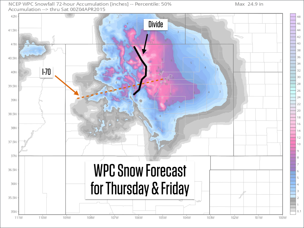
Source: Weatherbell.com
Friday: Snow showers will linger in the morning with maybe another inch or two. This will be your best chance to ride powder for at least the next four days, so go get some!
The weekend through next Tuesday: It should be dry as a cold storm hangs around the west coast. As I mentioned earlier, we could see dust return around next Tuesday, about a day before this west-coast storm finally moves east toward Colorado.
Next Wednesday, April 8th: Likely when we'll see our next chance for snow.
Happy April Fools, day! I hear that snowblades are making a comeback ...
JOEL GRATZ
Geography Key:
Northern Mountains
Steamboat, Granby, Beaver Creek, Vail, Ski Cooper, Copper, Breckenridge, Keystone, Loveland, Abasin, Winter Park, Berthoud Pass, Eldora, Rocky Mountain National Park, Cameron Pass
Along the Divide
Loveland, Abasin, Winter Park, Berthoud Pass
East of the Divide
Eldora, Rocky Mountain National Park, Cameron Pass
Central Mountains
Aspen, Sunlight, Monarch, Crested Butte, Irwin, Powderhorn
Southern Mountains
Telluride, Silverton, Durango, Wolf Creek (Telluride and Silverton are on the northern side of the southern mountains)
About Our Forecaster
Joel Gratz
Founding Meteorologist
Joel Gratz is the Founding Meteorologist of OpenSnow and has lived in Boulder, Colorado since 2003. Before moving to Colorado, he spent his childhood as a (not very fast) ski racer in eastern Pennsylvania.
Free OpenSnow App


