Colorado Daily Snow

By Joel Gratz, Founding Meteorologist Posted 8 years ago April 25, 2015
Monday morning powder at higher elevations
Summary:
- Another day of scattered showers on Saturday
- Showers continue for San Juans on Saturday night & Sunday
- Heaviest snow will fall Sunday evening through Monday morning
- Highest accumulations along and east of the divide, south of Pikes Peak
- San Juans should do well, as should Abasin and Loveland
- Monday should offer the most powder
- Warmer for the rest of next week
Details:
I am writing this on Friday night as I will be up early on Saturday to (hopefully) skin up and ski down a nice little hill in the southern Gore Range.
After looking at the latest models, I don't have any big changes to the forecast that I wrote this morning (http://opsw.co/1GrLzt8).
Saturday will be another day with afternoon showers. The only difference between Saturday and the previous five days is that areas west of about Vail (essentially the western half of the mountains) could see showers push through during the morning hours in addition to the afternoon hours.
On Saturday night into Sunday morning, our storm will move closer and position itself near the four corners. Most models are showing precipitation during this time over the San Juans, while the rest of the state stays drier.
Then we'll see the heaviest precipitation from Sunday afternoon through Monday morning. Most areas along and east of the divide should see at least 1 inch of precipitation, which would equate to 8-10 inches of snow over about 9,000 feet. Snow might accumulate down to 8,000 feet on Sunday night, with flakes down to 7,000 feet during the times of heavier precipitation.
Of the region along and east of the divide, the models are trending the heaviest precipitation toward areas south of Pikes Peak, around the Wet Mountains and the east slopes of the Sangre de Cristo mountains. Precipitation amounts could be 2-4 inches in this area, which could equate to 15-30 inches of snow.
West of the divide, the San Juans will be favored with perhaps 1+ inches of precipitation, or about 10+ inches of snow.
Other areas that I didn't mention should see some snowfall, though amounts will likely stay under about 6-8 inches.
The map below shows the storm total precipitation forecast from four models. All of them roughly agree that along and east of the divide will see the most precipitation, with the bullseye in the southeastern mountains.
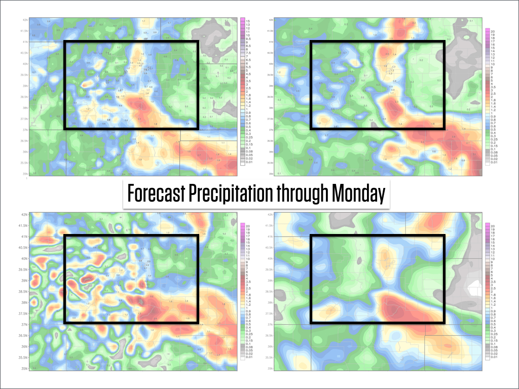
Source: weatherbell.com
Monday looks like the best powder day, and with May quickly approaching, it will likely be one of the last powder days of the season. Yes, we might see another cool storm during the month of May, but with temperatures warming quite a bit next week, I'd say Monday is a good bet if you want to ski powder before November 2015. The only resorts open on Monday will be Abasin and Loveland, and they should both offer about 6-10 inches of fresh snow if everything goes according to plan.
Speaking of the snow forecast, I reverted the Colorado forecast page (http://opsw.co/CO1-5) back to an automated forecast because I wanted to see how our automated system handles this storm.
The automated system presents a combination of numbers from the National Weather Service and the European forecasting model (ECMWF), and the numbers I see on the Colorado forecast page look pretty good to me.
Ten years ago, when I started forecasting snow in Colorado, the computer models and many of us local forecasters had some rather large biases in our forecasts. Hence, learning the weather patterns that favor each mountain was a big deal, and I think the accuracy of my forecasts reflected this local knowledge.
However, the forecasting models have improved quite a bit in the last decade, and all of us local snow forecasters in Colorado have helped each other improve our forecasts, so I am now seeing that many snow forecasts look reasonable when accounting for the local affects of the mountains. Not all snow forecasts are the same, but many of them are now more reasonable.
This is a long way of saying that as snow forecasts are improving, I see a time very soon when I am not adding much value to the actual forecast numbers, but rather can bring the most value in interpreting the data and lending confidence to your decision making by saying "Yup, Monday looks like the day to me!" and/or "here are the uncertainties with the storm, and how they might impact your plans".
Anywho, that's it for now. Have a great day on Saturday, and I'll write another update on Sunday morning.
JOEL GRATZ
End of Season Survey - 5 to 10 minutes could win you $100 (stole that from GEICO). Thanks for your help!
http://opsw.co/season-survey
Geography Key:
Northern Mountains
Steamboat, Granby, Beaver Creek, Vail, Ski Cooper, Copper, Breckenridge, Keystone, Loveland, Abasin, Winter Park, Berthoud Pass, Eldora, Rocky Mountain National Park, Cameron Pass
Along the Divide
Loveland, Abasin, Winter Park, Berthoud Pass
East of the Divide
Eldora, Rocky Mountain National Park, Cameron Pass
Central Mountains
Aspen, Sunlight, Monarch, Crested Butte, Irwin, Powderhorn
Southern Mountains
Telluride, Silverton, Durango, Wolf Creek (Telluride and Silverton are on the northern side of the southern mountains)
About Our Forecaster
Joel Gratz
Founding Meteorologist
Joel Gratz is the Founding Meteorologist of OpenSnow and has lived in Boulder, Colorado since 2003. Before moving to Colorado, he spent his childhood as a (not very fast) ski racer in eastern Pennsylvania.
Free OpenSnow App


