Colorado Daily Snow

By Joel Gratz, Founding Meteorologist Posted 8 years ago April 26, 2015
Periods of heavy snow Sunday afternoon through Monday morning
Summary:
- Sunday morning: snow showers ongoing east of divide & San Juans
- Sunday midday and afternoon: snow becomes steadier, heavier
- Sunday night into Monday morning: heaviest snow east of divide
- Monday: snow lingers east of the divide
- Best total accumulations over 10,000 feet
- East of the divide could see 10+ inches, 20+ east of the Sangre de Cristos
- You'll find powder both Sunday and Monday morning - enjoy!
- Warmer Tuesday and beyond...
Details:
Saturday worked out as planned. Showers fell in the morning for the western half of the mountains, then showers filled in for most other mountains during the afternoon.
The surprise (to me, at least) came on Saturday evening and Saturday night as showers not only continued but increased in strength and coverage. This led to multiple waves of heavier snow that moved over many mountains, and resulted in 4-7 inches falling at the three remaining ski areas: 4 inches at Abasin and Winter Park, 7 inches at Loveland. Looking at the timelapse webcams, most of this snowfall came in just two, ~1hr bursts of snow. It is difficult to forecast the location and intensity of these bursts of snow. Even though it is a surprise, it's great to see these higher totals this morning.
Now on Sunday morning, our storm is spinning over east-central Arizona, and it is slowly moving to the east, toward New Mexico.
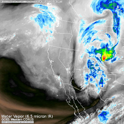
Under the clouds shown above on the satellite image, there are two areas of heavier precipitation affecting Colorado. One is near and north of Denver where convection (thunderstorms) are ongoing this morning. The other area is near Grand Junction and extending south into the San Juans. The image below shows a 1hr 15min radar animation.
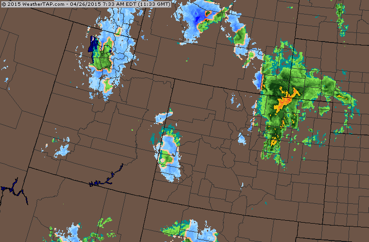
Image sources: weathertap.com
For the rest of Sunday, look for somewhat calm conditions this morning. Yes, there are showers falling on the areas I mentioned above, but many mountains will see drier weather in the AM.
Then showers will increase quite a bit after noon, and from noon through Sunday evening, showers will fill in over most mountains in Colorado. Look for the heaviest snow to fall over 10,000 feet, though flakes could briefly flirt with 8,000-9,000 feet during heavier showers.
From late Sunday evening into Monday morning, snow showers will decrease west of the divide, but these showers will be steady or increase along and east of the divide. The heaviest snow east of the divide will likely fall in southern Colorado, along the east slopes of the Sangre de Cristo mountains and into the Wet mountains.
On Monday, snow showers will linger along and east of the divide while most of the western mountains will be drier in the morning with a few showers popping up during the afternoon. Total snowfall from Sunday morning through Monday morning will likely be 6 inches or less west of the divide with closer to 10-15 inches along and east of the divide. Totals could be more than 20 inches east of the divide, along and east of the Sangre de Cristo mountains.
The best powder will likely be Sunday morning (based on the surprise snow that fell on Saturday night), then Sunday late afternoon, and Monday first chair. Enjoy!
Next Tuesday through Friday looks warmer. Wednesday and Thursday should stay dry all day, with afternoon showers perhaps returning to the forecast on Friday or Saturday.
JOEL GRATZ
End of Season Survey - 5 to 10 minutes could win you $100 (stole that from GEICO). Thanks for your help!
http://opsw.co/season-survey
Geography Key:
Northern Mountains
Steamboat, Granby, Beaver Creek, Vail, Ski Cooper, Copper, Breckenridge, Keystone, Loveland, Abasin, Winter Park, Berthoud Pass, Eldora, Rocky Mountain National Park, Cameron Pass
Along the Divide
Loveland, Abasin, Winter Park, Berthoud Pass
East of the Divide
Eldora, Rocky Mountain National Park, Cameron Pass
Central Mountains
Aspen, Sunlight, Monarch, Crested Butte, Irwin, Powderhorn
Southern Mountains
Telluride, Silverton, Durango, Wolf Creek (Telluride and Silverton are on the northern side of the southern mountains)
About Our Forecaster
Joel Gratz
Founding Meteorologist
Joel Gratz is the Founding Meteorologist of OpenSnow and has lived in Boulder, Colorado since 2003. Before moving to Colorado, he spent his childhood as a (not very fast) ski racer in eastern Pennsylvania.
Free OpenSnow App


