Colorado Daily Snow

By Joel Gratz, Founding Meteorologist Posted 8 years ago November 25, 2015
Southern Powder
Summary
A stalled storm will push light snow over Colorado from Wednesday night through the weekend, but the only deep powder will be in the southern mountains around Wolf Creek. The long-range forecast looks to be on the dry side.
The Colorado Daily snow is brought to you by…
… your recently opened Arc’teryx Equipment Denver Store. For a pinnacle brand experience and a full selection of Arc’teryx gear, visit us in the Cherry Creek North Shopping District. Enter in-store for your chance to win an Arc’teryx Cerium LT Hoody, the perfect down jacket for Colorado. Contest ends December 31st, 2015. For more information about the Arc’teryx Denver Store, visit http://opsw.co/1OC65OF
Details
Our next storm is spinning over Lake Tahoe as of Wednesday morning and it dropped anywhere from 6 to 16 inches of snow on the mountains of California.
In a more normal weather situation, this storm would move east toward Colorado during the next day, bring a healthy 5-10 inches to many areas, and most of us would enjoy fresh powder.
Unfortunately, this storm is not going to behave in a normal way. Instead, it is going to stall and spin between California and Colorado for the next 5-6 days.
Since the brunt of the storm’s energy will NOT reach Colorado and rather will stay to our west, I am NOT forecasting a lot of snow for most areas of the state.
Our first chance for seeing flakes will be late Wednesday night into Thursday morning. The winner of the Wednesday night forecast will likely be the American GFS model which has consistently predicted very little snow for most mountains. The often more accurate European model was predicting a few inches of snow, but has since trended its forecast downward.
So, for Wednesday night into Thursday morning, most locations will see little snow. The exceptions will be east of the divide in the foothills west of the Denver metro area (1-3 inches, also getting very cold in this area!), in the western mountains as a band of snow may get just far enough into Colorado for 1-3 inches at Powderhorn, Sunlight, and Steamboat, and perhaps a few inches around Wolf Creek which does well with a southwest wind.
For Thursday and Thursday night, the heaviest snow will be east of the divide to around the Denver metro area where another 1-3 or 2-4 inches could fall. Wolf Creek should also see about the same amount, while other areas see just scattered showers and light accumulations.
On Friday, again most mountains will see light accumulations, if any. Monarch has a better chance to get 2-4+ inches with a wind from the east, and Wolf Creek is the wildcard as the models are oscillating between forecasting just 1-2 inches on Friday or 6+ inches. Of anywhere in Colorado, Wolf Creek has the best chance for heavier snow on Friday, but I only have moderate confidence in this.
From Friday night through Saturday, I have higher confidence of heavier snow at Wolf Creek with 6-12+ inches. Once again, Monarch could see decent totals (2-4 or 3-6 inches), while most other mountains see light accumulations.
The final part of the storm will be from Saturday night through Tuesday morning. This is when the brunt of the storm’s energy should finally move over and to the east of Colorado, and the winds will switch to blow from the west and northwest. A wind from the west and northwest favors the central and northern mountains, so I put a couple extra inches in the forecast for these areas from Sunday afternoon through Monday.
If you’re looking for powder, Wolf Creek has the highest odds of a deep powder day on Saturday with some potential for Friday. Monarch is next in line with medium odds of a moderate powder day on Friday or Saturday. Most other mountains will see just 1-3 inches through the weekend, with a slightly better chance for higher totals from Sunday afternoon through early next week.
Here is the precipitation forecast from Wednesday through Saturday from the Canadian model. I like parts of the forecast from the Canadian, American, and European model, and averaging all of the models is roughly how I create the snow forecast for each ski area in Colorado. I am showing the Canadian model here because it’s closest to my averaged forecast. Multiply by about 15 to estimate snowfall as the map is given in liquid equivalent precipitation. You can see the highest totals around Wolf Creek.
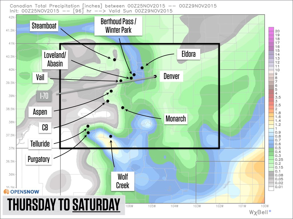
Source: Weatherbell.com
Below is the same precipitation forecast as I just showed, but now extending through early next week. Notice the additional snowfall in the central and northern areas. It’s not a ton, but something at least.
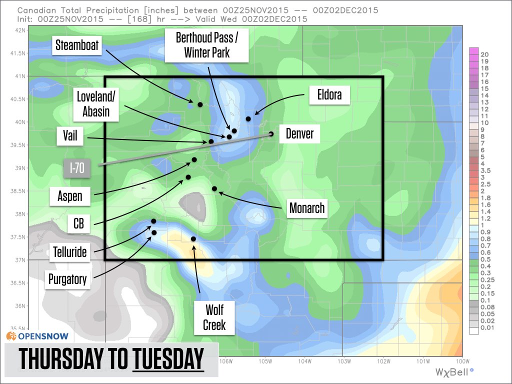
Source: Weatherbell.com
After this storm passes, we will transition to a more El Nino-like pattern with a ridge of high pressure to our north and a stormy trough of low pressure out over the north-central Pacific Ocean. This will likely mean a trend toward drier weather over the next two weeks (boo), but I can’t rule out the possibility of a storm or two sneaking under the ridge and bringing snow to Colorado.
This is the forecast pattern for late next week:
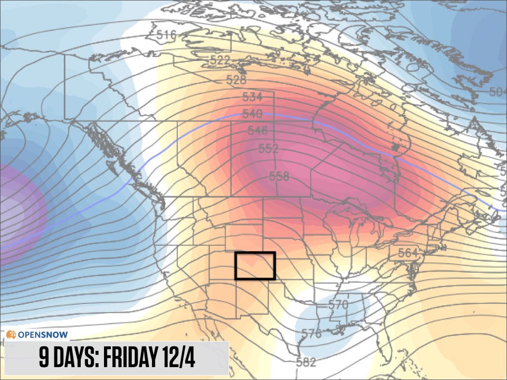
Source: Weatherbell.com
And then for the following week, toward the middle of December:
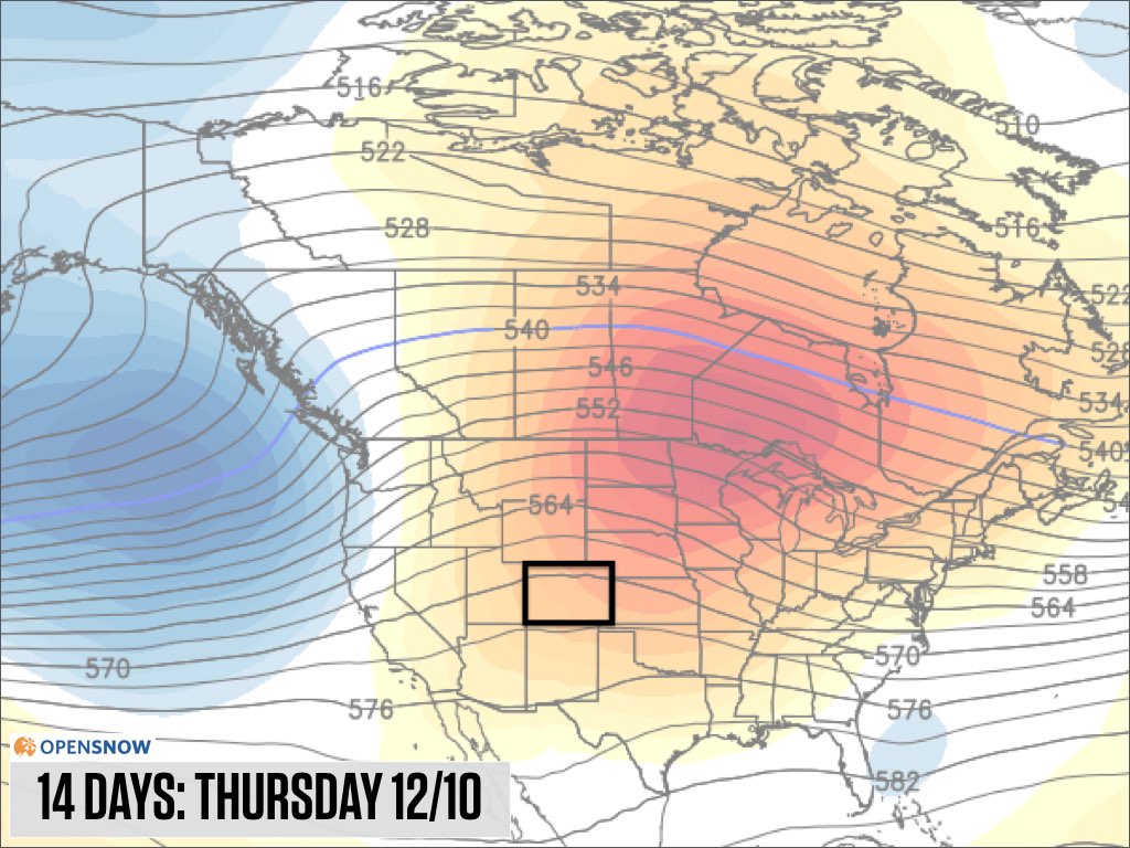
Source: Weatherbell.com
Past strong El Ninos have generated average to above average snowfall in Colorado during October and November, only to lead to drier weather in December.
Based on the current long-range models, it looks like this El Nino season is so far following the trend of the past seasons.
That’s a bummer for the December outlook, BUT, like I said, having a ridge to our north only decreases the chances for storms and does NOT rule out the possibility that storms do sneak under the ridge. So while I have low expectations for powder days in the first two weeks of December, I am not losing hope that we can get lucky once or twice.
Stay tuned…next update on Thursday morning. Thanks for reading!
JOEL GRATZ
About Our Forecaster
Joel Gratz
Founding Meteorologist
Joel Gratz is the Founding Meteorologist of OpenSnow and has lived in Boulder, Colorado since 2003. Before moving to Colorado, he spent his childhood as a (not very fast) ski racer in eastern Pennsylvania.
Free OpenSnow App


