Colorado Daily Snow

By Joel Gratz, Founding Meteorologist Posted 8 years ago November 27, 2015
A better handle on things…
Summary
So far, Wolf Creek is the winner and they will again likely see the most snow on Friday night into Saturday. Other mountains should see two rounds of steadier snow, first on Friday night into Saturday then again on Sunday afternoon through Monday. After this storm, most of next week looks dry.
The Colorado Daily snow is brought to you by…
… your recently opened Arc’teryx Equipment Denver Store. For a pinnacle brand experience and a full selection of Arc’teryx gear, visit us in the Cherry Creek North Shopping District. Enter in-store for your chance to win an Arc’teryx Cerium LT Hoody, the perfect down jacket for Colorado. Contest ends December 31st, 2015. For more information about the Arc’teryx Denver Store, visit http://opsw.co/1OC65OF
Details
From Wednesday morning through Friday morning, the most snow from this system has fallen over the southern and south-eastern mountains. Some areas west of Pueblo received 10-12 inches, and Wolf Creek has also received about this much snow, with their snow report totaling 11 inches and nearby SNOTEL sites saying about the same thing. Here is the 48-hour SWE (snow-water equivalent) accumulation across the state. Multiply by about 12 to estimate snowfall.
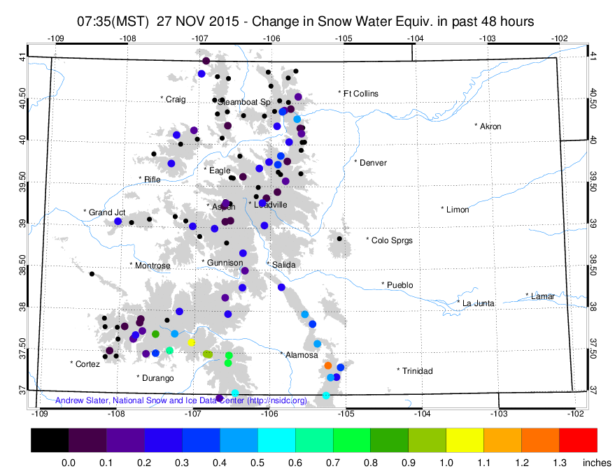
Source: Dr. Andrew Slater
The center of the storm is west of Colorado, and as we’ve talked about for days, this storm has stalled and is not in any hurry to move to the east. Instead, it is wobbling around, with pieces of energy circling the center of the storm.
As of Friday morning, we’re in a lull, between these pieces of energy, but that will change as another piece of energy creates a round of snowfall between Friday afternoon and Saturday morning. During this time, look for the heaviest snow to fall around Wolf Creek (6-12 inches) with lighter amounts for most other mountains (in the 1-3 inch range). I have the highest confidence in the totals around Wolf Creek and the southern mountains, with moderate confidence for all other central and northern mountains. While Friday night’s snow will cover a broader area than we’ve seen during the last few days when precipitation has been dominated by narrow bands of snow, there will still be banding in the snowfall on Friday night, so some mountains may get missed and receive little snow while other mountains could get lucky, sit under a band for many hours, and get more than 3 inches. In any case, Saturday morning should offer soft turns for most mountains, with powder ranging from a few inches in the north and central areas to double digits around Wolf Creek.
We should see a break in the snow from Saturday midday through Sunday midday, then another round of moderate to heavier snow should fall from Sunday evening through Monday, this time favoring the central and northern mountains. As winds switch to blow from the west and northwest, Monday could be a moderate powder day with 3-6 inches for most mountains. I have low-to-medium confidence in this time frame. The models are slowly beginning to agree on the details, though, so I’m hoping to increase my confidence by Saturday morning’s update.
To recap, look for a round of snow Friday night into Saturday morning favoring the southern mountains, then another round of snow Sunday evening through Monday favoring the northern and central mountains.
From Tuesday through most of next week, I think most of the state will stay dry. A storm could bring snow to southern Colorado late next week or next weekend (December 4-6th), but this storm could also track too far to the south and miss Colorado completely.
Beyond next week, most models agree that dry weather will continue through about December 10th, with our next storm possible around that weekend (December 11-13th). Yes, this is a 15 day forecast, and yes, the details of 15 day forecasts should not be trusted. But when all three major computer models (European, Canadian, American) are in agreement on the general weather pattern, we can be more confident in their forecasts. In short, next week and the following week will be on the drier side, with perhaps more active weather during the second half of December according to the 30-day European ensemble.
I’ll check back in on Saturday morning, hopefully with an update on some snow that fell on Friday night, and with a more confident forecast for the Sunday to Monday time frame.
Also, don't forget that you can see detailed forecasts (and more snow data) on each mountain's page, such as Wolf Creek, and see a comparison of all mountains in Colorado on the state page, which has tabs for 1-5 day forecasts, 6-10 day forecasts, snow reports, snow history, and webcams.
Thanks for reading!
JOEL GRATZ
About Our Forecaster
Joel Gratz
Founding Meteorologist
Joel Gratz is the Founding Meteorologist of OpenSnow and has lived in Boulder, Colorado since 2003. Before moving to Colorado, he spent his childhood as a (not very fast) ski racer in eastern Pennsylvania.
Free OpenSnow App


