Colorado Daily Snow

By Joel Gratz, Founding Meteorologist Posted 8 years ago November 29, 2015
More snow Sunday through Monday Night
Summary
Another round of snow will fall from Sunday midday through Monday night, initially favoring the southern mountains then transitioning to focus on the central and northern mountains. The best powder day of the next 7-10 days should be on Monday for many places, so get after it:-)
The Colorado Daily snow is brought to you by…
… your recently opened Arc’teryx Equipment Denver Store. For a pinnacle brand experience and a full selection of Arc’teryx gear, visit us in the Cherry Creek North Shopping District. Enter in-store for your chance to win an Arc’teryx Cerium LT Hoody, the perfect down jacket for Colorado. Contest ends December 31st, 2015. For more information about the Arc’teryx Denver Store, visit http://opsw.co/1OC65OF
Details
I hope you had a nice Saturday enjoying the snow across Colorado. The winners on Saturday morning were Wolf Creek with another 8 inches (storm total of 19 inches), as well as Snowmass, Beaver Creek, Vail, and Winter Park, which saw a narrow band of moderate snow that accumulated around 4-6 inches in the hours around sunrise on Saturday.
On Saturday, I was up in Rocky Mountain National Park enjoying a few low-angle backcountry turns. We found snow depths ranging from 6 inches to 30 inches, which meant we were either skiing on grass or in knee-deep powder. Such is the early season!
Speaking of Rocky Mountain National Park, here is a webcam view of the sunrise from the Alpine Visitor’s Center at 11,800 feet on Sunday morning. I look at all webcams across Colorado each morning, and if I see something beautiful, like this shot, I’ll be sure to post it. Webcams at each mountain are free to view, and if you’d like to view all webcams on one page, that’s a benefit of signing up for our All-Access Pass.
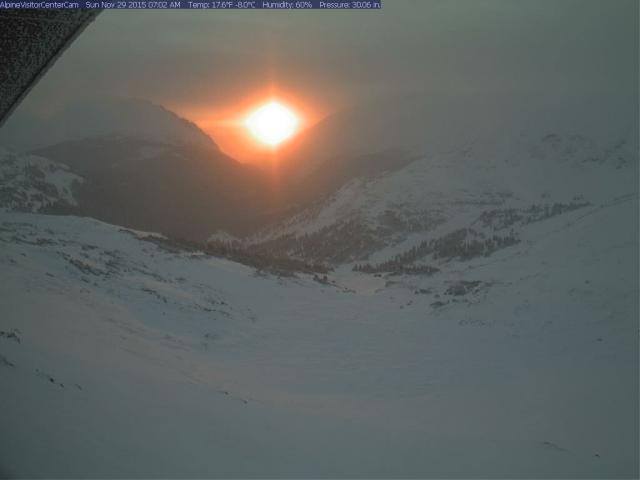
Source: NPS / OpenSnow.com
From Saturday mid-morning through about sunrise on Sunday, most mountains have been dry. There is an exception, though. One narrow band of snow brought 1-3 inches of fresh snow to Powderhorn, Sunlight, Cooper, Beaver Creek, Vail, Copper, and Steamboat around sunrise on Sunday morning. This snow should dissipate early in the day, giving way to partly sunny skies.
The center of our current storm is still to the west of Colorado, swirling over the Utah/Nevada border. You can clearly see this swirl on the Sunday morning water vapor satellite imagery. You can also see a mass of light grey (mid-level moisture) over northern Arizona that is moving toward Colorado. This will bring additional snowfall on Sunday afternoon and evening.
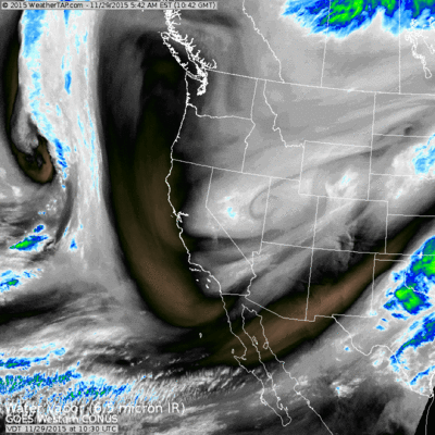
Source: Weathertap.com
For Sunday, look for a dry start to the day, with snow developing around midday in the southern mountains (Telluride, Silverton, Purgatory, Wolf Creek), and then pushing northward to the central mountains (Monarch, Crested Butte, Irwin, Aspen) by late afternoon. This snow should then impact the I-70 corridor from Beaver Creek east to Loveland and Berthoud Pass by early Sunday evening.
On Sunday night, the snowfall will continue. There is a chance that the snow will fall somewhat heavily around the divide (Echo, Eldora, maybe back to Berthoud Pass, Winter Park, Loveland, Abasin, and Keystone), so watch out for a few extra inches at these areas. Other locations will continue to see snow, but as the wave of energy moves to the east, snowfall should decrease in the southern mountains around Purgatory and Wolf Creek. Also, I am not sure how far north the snow will get, so not all areas along I-70 could see significant snow.
For Monday, a moist west to northwest wind should keep the snow going for the northern part of the southern mountains (Telluride, Silverton) as well as the central mountains around Aspen and Monarch, and up through the I-70 corridor. Steamboat should also see good snow.
And on Monday night, I think the snow will continue through about midnight for the I-70 mountains up to Steamboat.
Putting all of this together, I think the best snow will be found on Monday for most mountains, and Tuesday first chair could also offer good powder along and north of I-70. Total snow amounts should be at least 3-6 inches for most mountains, with 6-12 inches for the mountains along and north of I-70 if we can get this northwest flow to produce. Since the forecast is mostly dry from Tuesday through the middle of next week, Monday and Tuesday morning would be a great time to take advantage of the fresh snow.
I know that the combination of geography (southern, central, northern mountains) and time periods can get overwhelming, so if you get confused about the timing and location of my snow forecast, head to each mountain’s page to get detailed information. You can search for any mountain to go directly to their page.
The following forecast is from the high resolution NAM 4km model. It shows the forecast radar, and you can see three distinct snowfall patterns. The first is the narrow band of snow in the northern mountains on Sunday morning, then a break, then snow begins in the southern mountains and moves north on Sunday night, and then snow showers continue for the central and northern mountains on Monday and Monday night.
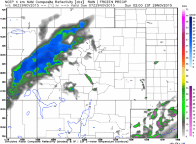
Source: Weatherbell.com
After this storm, Tuesday through Friday should be dry, then we’ll see a chance of light snow on Saturday December 5th. This storm does not look very strong, so I just put a few inches in the forecast.
The early part of next week should go back to dry weather (December 6-9th), then our next chance for a storm will be later next week or the following weekend (December 10-13th).
Have a great Sunday, and thanks for reading!
JOEL GRATZ
About Our Forecaster
Joel Gratz
Founding Meteorologist
Joel Gratz is the Founding Meteorologist of OpenSnow and has lived in Boulder, Colorado since 2003. Before moving to Colorado, he spent his childhood as a (not very fast) ski racer in eastern Pennsylvania.
Free OpenSnow App


