Colorado Daily Snow

By Joel Gratz, Founding Meteorologist Posted 8 years ago December 1, 2015
Dry weather for a few days
Summary
Following our five-day storm, we’ll see dry weather through the rest of the week with slowly warming temperatures. Weak storms could bring a bit of snow on Saturday 12/5 and Tuesday 12/8. A stronger storm is likely between about Thursday 12/10 and Sunday 12/13.
The Colorado Daily snow is brought to you by…
Taos Ski Valley, New Mexico. Located just 50 miles south of the Colorado border, Taos Ski Valley is a mystical haven for 300+ inches of bone-dry powder stashes and some of the most untamed chutes, bowls and glades in North America. And with nearly half of all trails rated for beginners and intermediates, its unpolished charm and cheeky mountain rituals welcome anyone with a spirit of adventure. Learn more at SkiTaos.com/secrets
Details
Our storm wrapped up yesterday (Monday) with a cold, moist flow from the northwest. Sometimes this northwest flow can produce 6-12+ inches for the central and northern mountains, but unfortunately we lacked the moisture necessary to create big totals. Instead, most areas saw just 1-3 inches, with higher amounts in a few places, like Winter Park and Monarch which measured 5 inches, and Steamboat which report 4 inches.
Storm total snowfall since Thanksgiving ranged from just 3-6 inches for some mountains, all the way up to about 32 inches at Wolf Creek. For the most part, this was a storm that brought consistent snow during many days rather than huge one-day totals. Many skiers and riders search for big numbers on a single-day snow report, but consistent light snow amounts during multiple days can actually create better conditions as the base is soft and the turns feel bottomless.
Looking ahead, we will start the day on Tuesday with temperatures near 0F for most mountains, and the air should warm into the teens under mostly sunny skis (still some moisture and clouds hanging around the northern mountains).
The rest of the week will be dry, and temperatures will warm each day, reaching into the 30s and maybe low 40s for highs on Thursday and Friday.
Looking ahead to the next 10 days, I see three chances for snowfall.
First, for comparison, here is the weather pattern today, on Tuesday. You can see our past storm (blue colors) exiting to the east of Colorado.

Source: Weatherbell.com / OpenSnow.com
On Saturday, a weak system will move across Colorado. I am confident that our temperatures will cool by 5-10 degrees, but I am not confident in snowfall amounts. At this point, I put 1-2 inches in the forecast, and that might be overdone.
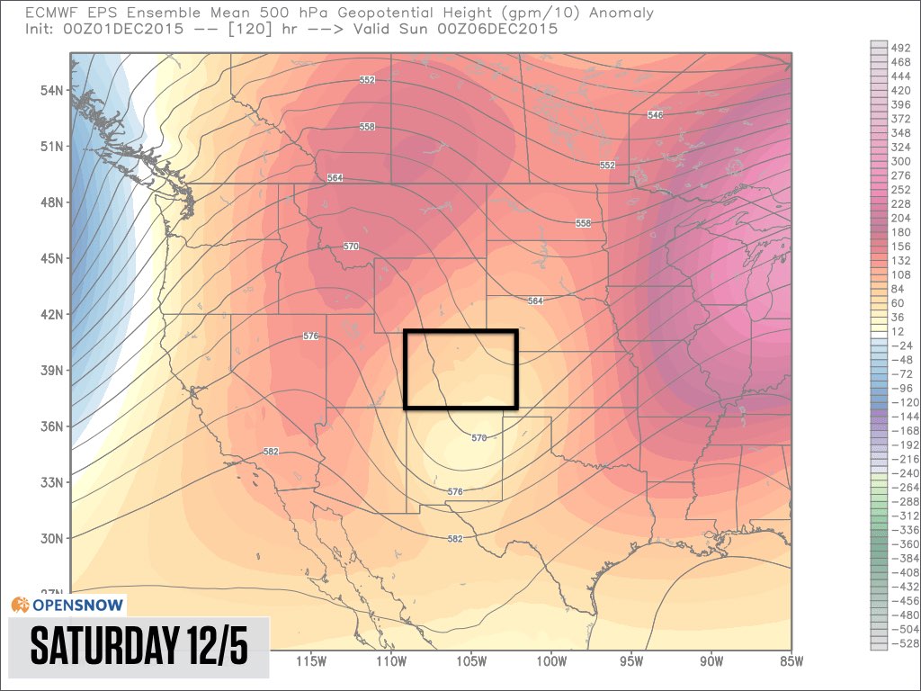
Source: Weatherbell.com / OpenSnow.com
Sunday and Monday should be dry, then we could see another weak storm around Tuesday, December 8th. The black lines that dip to the south, along with more neutral coloring, show this potential storm.
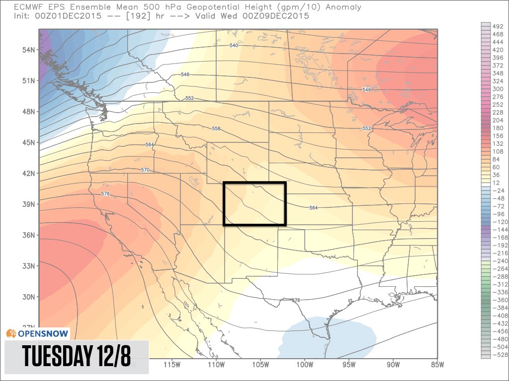
Source: Weatherbell.com / OpenSnow.com
We could see drier weather return on Wednesday, December 9th, then all models are showing a strong storm sinking into the Rockies between about Thursday December 10th and Sunday December 13th. It’s too soon to confidently predict this storm’s track and snowfall, but I am confident that we’ll have something fun to talk about later next week.
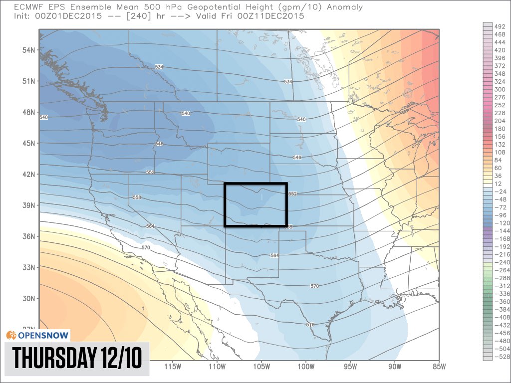
Source: Weatherbell.com / OpenSnow.com
Have a great Tuesday and stay warm out there:-)
JOEL GRATZ
About Our Forecaster
Joel Gratz
Founding Meteorologist
Joel Gratz is the Founding Meteorologist of OpenSnow and has lived in Boulder, Colorado since 2003. Before moving to Colorado, he spent his childhood as a (not very fast) ski racer in eastern Pennsylvania.
Free OpenSnow App


