Colorado Daily Snow

By Joel Gratz, Founding Meteorologist Posted 8 years ago January 11, 2016
We’re doing OK in split flow!
Summary
While the overall weather pattern is not conducive to consistent cold air and snow in Colorado, we will likely eek out as much snow as we can from the pattern, and I’m thrilled about that. Monday through Wednesday will be dry, then most of Colorado will see snow from Thursday through Saturday with the heaviest amounts in the central and northern mountains. Friday or Saturday could be a low-to-moderate powder days.
A Special Thanks to Our Sponsor
Powder7 Ski Shop in Golden, Colorado is your local, family-owned, internet ski and ride superstore. With thousands of new and used skis, as well as boots, bindings, helmets, and clothing, Powder7 has all the gear you need to conquer winter. They’ll also deliver within Colorado in one business day. Shop the entire inventory online or stop by the Golden storefront. Shop Powder7: http://opsw.co/1SjYxxK
Details
Sunday was a partly to mostly sunny day across Colorado. The snowfall from Friday through Sunday morning favored the northern mountains, and Steamboat in particular as they had a four-day total of about 15 inches. The snow was quite fluffy and I heard conditions were good! This is yet another demonstration of how consistent light snow over three or four days can lead to really fun conditions, even if no single day’s snow report shows a big number.
I bring up this consistent snowfall during the last few days to foreshadow the forecast for the next 7-10 days. I do not see any big-time storms that will impact Colorado, but I do see chances for snow during many days from late this week, through the weekend, and perhaps into early next week.
The weather pattern during the upcoming week will look like this. The northern Pacific Ocean will see consistent storminess. Most of the energy from the northern Pacific will ride north and northeast into Alaska and parts of the northwest, but some energy will sneak through the ridge along the west coast (where the black lines bulge northward) and move into the central Rockies, around Colorado. Also, notice on the map that the northeast will finally get five days of consistent cold weather. They need it!
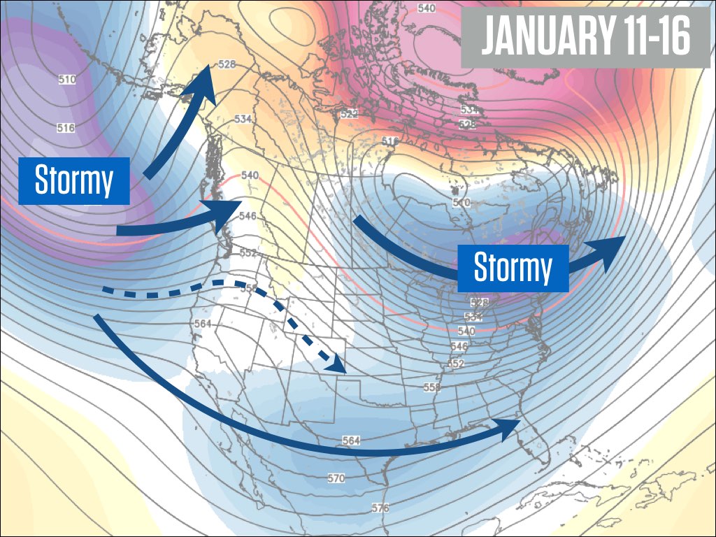
Source: Weatherbell.com
The weather pattern shown on the map above is typical of what we normally see during January of an El Nino winter. And it will likely stick around for the next few weeks. Here is the same map as above, but for January 16-21. Looks similar to this week, eh?
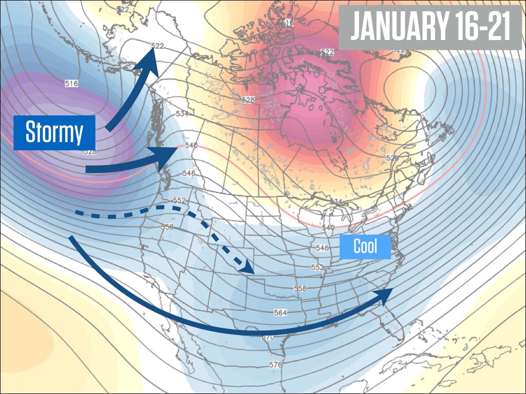
Source: Weatherbell.com
And looking ahead to January 21-26, the pattern should hold.
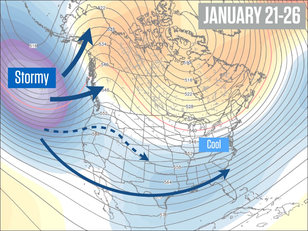
Source: Weatherbell.com
Just because the general weather pattern will be similar for the next 15 days, it doesn’t guarantee that we’ll see the same type of storms for the next two weeks. As I mentioned, the storms that we’ll get in Colorado during this pattern are largely the leftovers from the storminess in the northern Pacific. Sometimes these leftovers can track near Colorado and bring us significant snow, and sometimes the leftovers will miss Colorado and we would see dry weather or just light snow. And sometimes one part of the state will see snow while most other parts remain snowless.
I have moderate to low confidence in forecasting the track of each of these leftover storms during the next two weeks, but I have enough confidence to say that we’ll likely see three chances for snowfall from these systems: Thursday 1/14 to Saturday 1/16, Sunday 1/17 through Monday 1/18, and then later the following week from about Wednesday 1/20 through Friday 1/22.
I have too little confidence to provide any details around the second and third, storm, so I’ll focus on the first storm.
After dry weather on Monday, Tuesday, and Wednesday, snow should move into the state sometime on Thursday, and it will likely continue, through Saturday. This 48-hour period of snowfall will be brought to us by two pieces of energy, so it may not snow consistently for the entire time. All mountains should see some accumulation, though it looks like the heaviest snow will be in the central and northern mountains. Right now, I’d target I-70 and north up to Steamboat as having the deepest totals by Saturday midday, which could be in the 6-12 inch range, with the highest amounts potentially at Steamboat. Friday morning could offer nice turns, with likely the deepest and softest turns on Saturday morning.
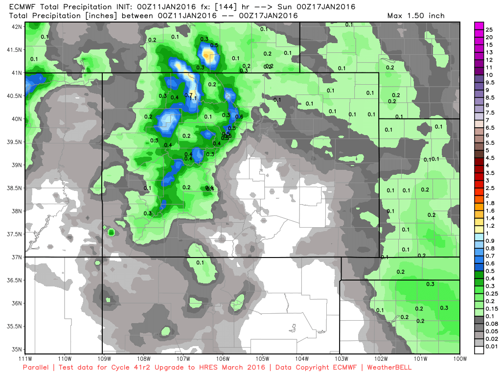
Due to licensing agreements, I cannot show detailed forecasts from the European model. However, I am going to take a liberty today because this model is being upgraded in early March and I want to show you the difference between the current model and the upgraded model.
The current model has a horizontal resolution of about 16km (9.6mi). This means that it can only recognize terrain and make forecasts for square grid boxes that are about 10mi x 10mi. This resolution is great for a model that covers the entire globe, but obviously it isn’t ideal where there are large changes in topography over short distances, such as the large mountains here in Colorado.
The newer version of the European model, which will become operational in March, is currently being tested and therefore we have some data to look at. This new version will increase the horizontal resolution to 9km (5.4mi). This improvement by itself may not make the model more accurate when predicting snowfall, but it will help it better understand the location and height of our big mountains, which potentially could help the model become more accurate.
Here are images from the current model and the upgraded model, showing total precipitation for the upcoming storm from Thursday through Saturday. This is liquid-equivalent precipitation, remember, so multiply by about 15 to estimate snowfall in inches.
The current version of the European:
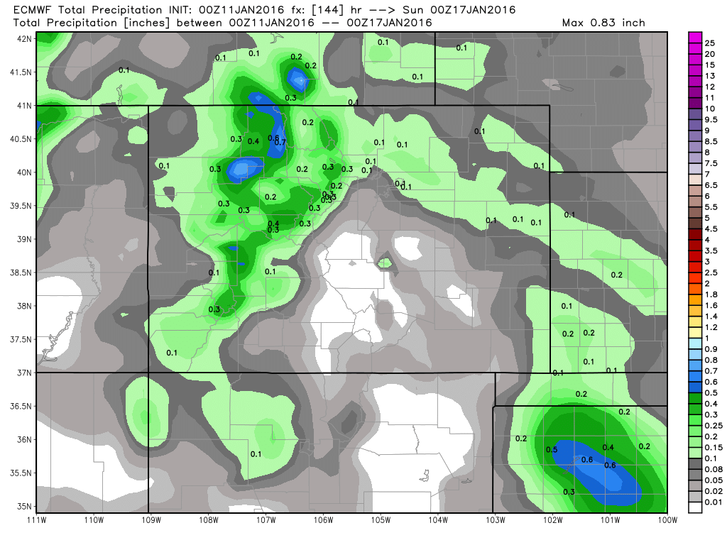
Source: Weatherbell.com
The new version of the European:
Source: Weatherbell.com
Notice that, in general, the new version is forecasting higher precipitation totals in areas that are favored by west and northwest winds (the central and northern mountains). I tend to agree with the potential for higher totals from this upcoming system, though of course we won’t be able to verify the model’s forecast until this storm is over and the snow is measured.
I am excited to keep looking at this new model data, and in March we should be able to make use of it for our forecasts on OpenSnow outside of Tahoe and Colorado, locations where we use adjusted data from the model rather than the hand-made forecasts by myself and Bryan.
For reference, the high-resolution WRF model from CAIC is 4km resolution, so the upgraded European model at 9km resolution is still roughly 2x less detailed, but it also covers the entire globe and is often the most accurate models when averaged over many storms, so it will be great to have this top-notch model at a higher resolution.
Ok, back to our weather here in Colorado…
I’ve said this during the last few days, but it’s worth repeating … the pattern we’re in right now could have easily left Colorado dry for two weeks, so the fact the we have chances for snow every few days is really about as good as this pattern can get. January is typically a dry month for Colorado during El Nino. If we can get through the month with near-average snow, that would be a huge bonus and could set us up nicely as we head into a likely snowier second half of the season.
Lastly, here is the link to a great video series created by Backcountry Access. The series includes short safety videos covering Avalanche Avoidance, Avalanche Rescue, and learnings from Avalanche Accidents. This is an awesome resource, and I think it’s well worth our time, whether as a review or as new information: http://backcountryaccess.com/learn-avalanche-safety/
Have an awesome Monday and I’ll be back with another update on Tuesday morning.
JOEL GRATZ
PS - New contest! Win a jacket/pant setup from Strafe Outwear. See a picture of the gear and enter the contest here: http://opensnow.com/contest
Geography Key
Northern Mountains
Steamboat, Granby, Beaver Creek, Vail, Ski Cooper, Copper, Breckenridge, Keystone, Loveland, Abasin, Winter Park, Berthoud Pass, Eldora, Rocky Mountain National Park, Cameron Pass
Along the Divide
Loveland, Abasin, Winter Park, Berthoud Pass
East of the Divide
Eldora, Rocky Mountain National Park, Cameron Pass
Central Mountains
Aspen, Sunlight, Monarch, Crested Butte, Irwin, Powderhorn
Southern Mountains
Telluride, Silverton, Durango, Wolf Creek (Telluride and Silverton are on the northern side of the southern mountains)
About Our Forecaster
Joel Gratz
Founding Meteorologist
Joel Gratz is the Founding Meteorologist of OpenSnow and has lived in Boulder, Colorado since 2003. Before moving to Colorado, he spent his childhood as a (not very fast) ski racer in eastern Pennsylvania.
Free OpenSnow App


