Mid-Atlantic Daily Snow

By Justin Berk, Posted 10 years ago January 24, 2014
Summary:
The cold will hold and more clippers bring more snow!
The Mid Atlantic is locked in an EPIC pattern. It’s colder her than out west and even much of Alaska as the coldest air is lopsided this season. This is the strongest and longest duration of cold we’ve seen since 1982. To give you an example, my home base of Baltimore just recorded the 8th day this month when temps reached the single digits. The record is 10 days set in January of 1982 and we are poised to break that mark in this final week of the month.
What does this mean for the ski areas? Champagne Powder! That is often the bragging rights from the Rockies, but we have it here. There will be great snow making conditions, but a few natural hits on the way.
Details:
Saturday: Clipper #1
This appears to be a broad base for snow region wide. It will arrive in the morning and last much of the day. With snow reaching the I-95 corridor that will only get more people in the mood for the slopes. So I expect it will be crowded, but worth it!
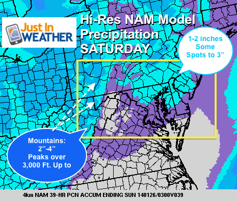
This is a precipitation forecast from the Hi Resolution NAM model. This does a decent job in the short term. It can be expected that based on how cold the air is, this will enhance the flakes in the high terrain of WV, western MD’s Wisp, and western PA where I expect 3-6 inches of new powder. Slightly lower amounts farther east, but southern PA and the Poconos should be stoked over a weekend, daylight snowfall of 1-3 inches. This breaks the warm weekend streak we had early this month and back in December for sure.
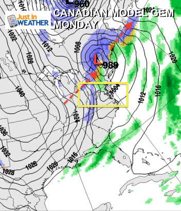
Sunday Night/Monday: Clipper #2
This will actually be a futile attempt for a slight warm up only to be followed by another arctic surge next week. The track is farther north, which does not favor the eastern sections of the Mid Atlantic. However, a solid burst of snow in the mountains will be the precursor for more arctic air.
Long Range:
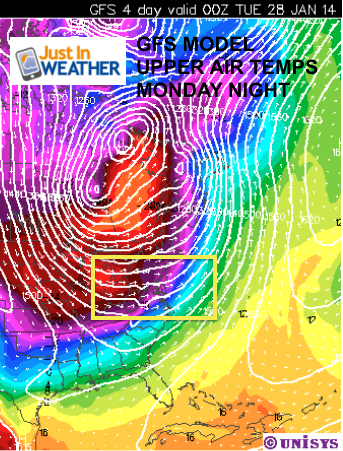
Trying to keep a handle on the arctic air and any disturbances around it can be tough. Once thing for sure, much of next week will remain in the deep freeze. The reinforcing block of the polar airmass will spill in Monday and Tuesday. Temperatures beyond that into the end of next week will range from afternoons in the teens (single digits farther west), and lows near or below zero.
Another storm? There are a few difference solutions for generating a system between next Friday and the following Tuesday. This all depends on how the arctic air behaves and dare I say, the precise location of the Polar Vortex. That should remain in eastern Canada, but it will drive the storm pattern into early February.
Faith-in-the-Flakes*
Also keep up to date via
Facebook: Justin Berk, Meteorologist
Twitter @JustinWeather
Instagram: justinweather
Kid Weather App
If you have a kid who loves the weather, check out my Kid Weather App that I made with my oldest son. It’s won a Parents Choice Award, been featured many times by iTunes, and even on Mashable’s Top 10 Apps to get kids interested in science. We are available for Apple and Android devices.
About Our Forecaster
Justin Berk
Free OpenSnow App


