Colorado Daily Snow

By Joel Gratz, Founding Meteorologist Posted 10 years ago January 30, 2014
Summary:
Heavy snow continues Thursday through Friday. Lots of details, so read below. Best powder days:
Northern and central mountains:
Thursday (storm skiing)
Friday (still snowing, less wind)
Saturday morning (maybe leftovers?)
Southern mountains:
Friday (storm skiing)
Saturday morning
Two storms are possible next week, one on Monday/Tuesday and another on Thursday/Friday.
Details:
The heaviest snow fell Thursday night along and north of I-70 with about 8-12 inches while the central mountains saw 3-6 inches. This was about 2-3 times the amount of snow I expected for the northern mountains along I-70. It looks like the moisture and storm energy overpowered a sub-standard wind direction, and voila.
The snow that fell last night was right around a 10:1 ratio, meaning 1 inch of liquid equals 10 inches of snow. This will feel much thicker than normal, and the lower ratio likely has to do with warmer temperatures, high moisture values, and the wind. Please post updates to our mobile app's LiveSnow feature so those of us that can't ski today know what's going on (download: iPhone and Android).
As I write this, cams are showing 2 inch / hour snowfall rates Thursday morning along I-70, and this might continue for sometime. This heavy snowfall should also expand to the central mountains throughout the day. You can see that the plune of rain and snow extends from Colorado all the way back to California and the Pacific Ocean, so this storm is a long way from over.
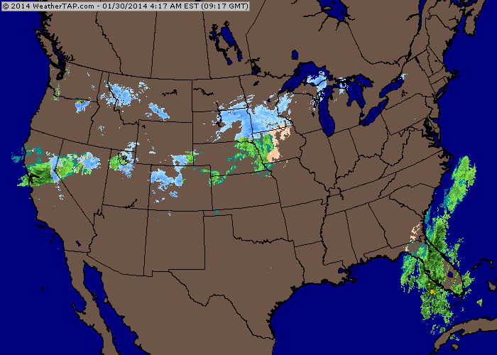
Thursday morning radar showing tons of precipitation extending 1,000 miles to the west of Colorado. Source: Weathertap.com
The models are throwing out an additional 1-2 inches of liquid over the next two days, which equates to 10-20+ inches of additional snow. After seeing what happened last night and what is happening this morning, these amounts look very reasonable, and perhaps even low. My snow forecast for each mountain is here (and based on 2"/hr snowfall this morning at some areas, today's forecast might be very low:-)
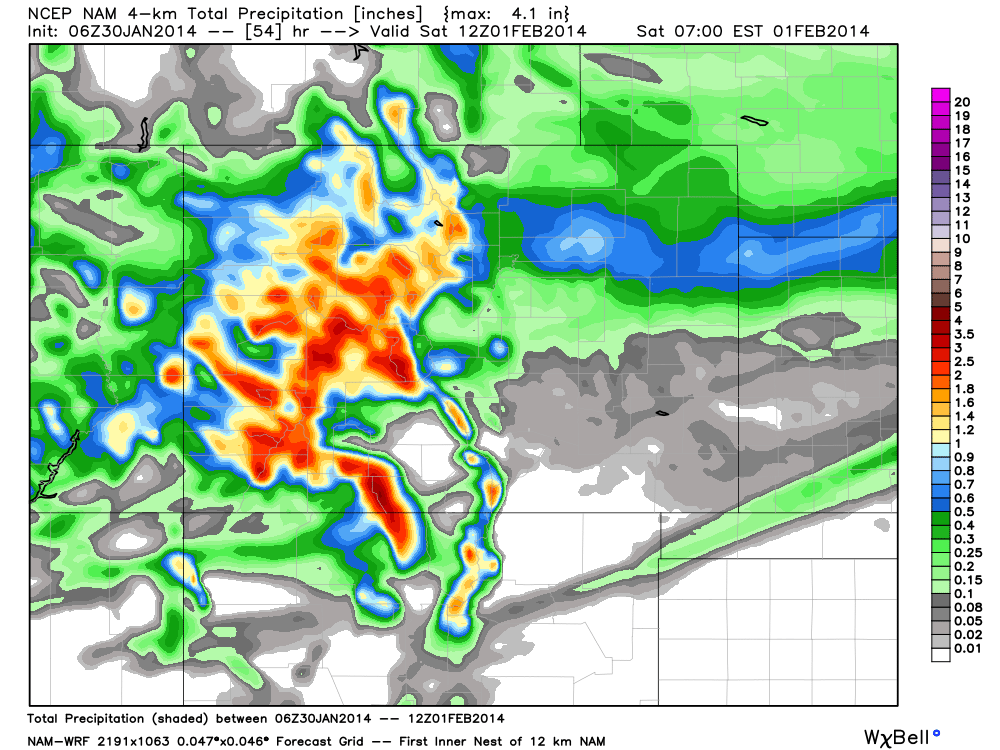
Precipitation forecast from Thursday morning through Saturday morning from the NAM 4km model. Multiply these amounts by 10 or 12 to estimate snowfall.
The heaviest snow will shift south of the I-70 corridor by late Thursday night or Friday morning, but heavy snow will continue for the central mountains through Friday. The southern mountains will see snow increase in intensity Thursday night and continue heavily through Friday. For the northern mountains along I-70, there should be a lull on Friday morning, but then light to moderate snow should return on Friday afternoon and Friday night with fluffy accumulations possible.
The roads in northern Colorado are already a mess in many areas as of Thursday morning, so check CDOT before you head out and expect a tough drive if you're not already where you want to be.
Long Range:
The weekend will be much more calm with snow showers on Saturday and dry conditions on Sunday.
The next storm will hit southern Colorado on Monday and Tuesday. I'm keeping my expectations low and expecting moderate accumulations for the San Juans and light amounts further north. The track of the storm could change a lot, and so too will the forecast so stay tuned for updates.
Another storm looks likely for Thursday and Friday. This one could again bring the most snow to the San Juans with less further north. It's too far out for any confidence, but keep an eye on it.
JOEL GRATZ
PS - our mobile apps are available for FREE! Download now: iPhone and Android. Also, since many of us ski "professionals" will be at the SIA Ski Conference in Denver today and won't be on the hill, please use the LiveSnow feature to post pictures and text updates about the current conditions so we can be jealous.
PPS - Don't let your kiddos miss out on all the snow! Kids in 5th grade can get a FREE 5th Grade Passport thanks to Colorado Ski Country USA. The Passport gets 5th graders three days of riding each at 20 different Colorado Ski Country partner resorts. For 6th graders the same deal is $99. Cool program, and the deadline to sign up is tomorrow, January 31, 2014! ColoradoSki.com/Passport
About Our Forecaster
Joel Gratz
Founding Meteorologist
Joel Gratz is the Founding Meteorologist of OpenSnow and has lived in Boulder, Colorado since 2003. Before moving to Colorado, he spent his childhood as a (not very fast) ski racer in eastern Pennsylvania.
Free OpenSnow App


