Tahoe Daily Snow

By Bryan Allegretto, Forecaster Posted 10 years ago February 5, 2014
Summary:
One last quiet day today before a very active period of storms over the next 4 days. The first system moves in tomorrow and could bring several inches of snow to all elevations. Then on Friday an atmospheric river sets up from Hawaii to Tahoe and sits there for 2 days. Snow levels start low with up to a foot at lake level before they rise Saturday night and fall again Sunday night. Several feet of snow possible on the mountain tops where it stays all snow. Quieter weather returns the first half of next week.
Details:
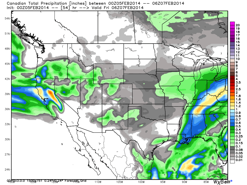
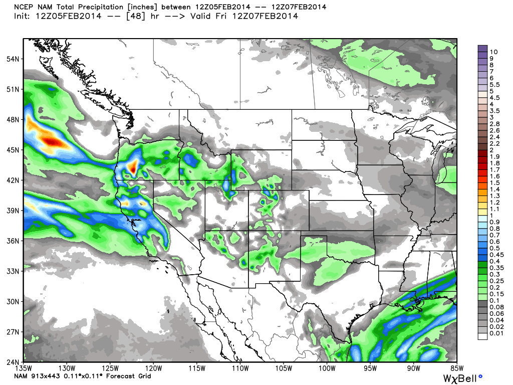
A very interesting and complex trend on the forecast models over the past 24 hours. The Canadian and European models were further South with the system for Thursday yesterday morning, and the GFS was aimed right at us. They completely flipped now with the GFS going South of the us and the more reliable Canadian, European and now the NAM models bringing the system straight into the area. Let's look at some of the model outputs for precip through Thursday night.
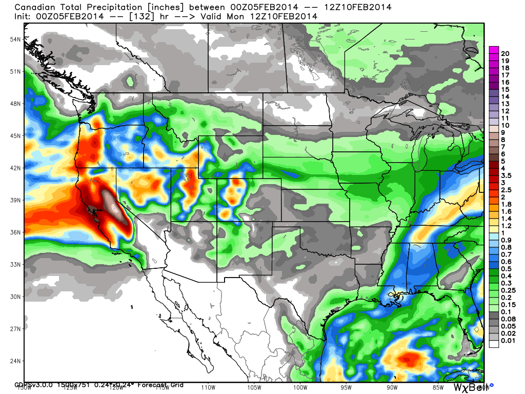
Canadian
NAM
GFS
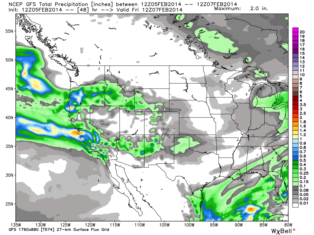
Kind of strange to see the disagreement on the GFS within 24 hours of a storm. It is the outlier with the other 3 models bringing the precip further North so we will throw it out but not forget the storm going further South is a slight possibility.
The snow should start falling during Thursday morning and then tapering off Thursday night. Looking at the liquid outputs it looks like we could pick up 3-6 inches at lake level, 6-9 inches above 7000 ft., and up to 12 inches along the crest. If the GFS is right it's 1-3 inches across the basin. I may update tonight if we get more clarity on snowfall amounts.
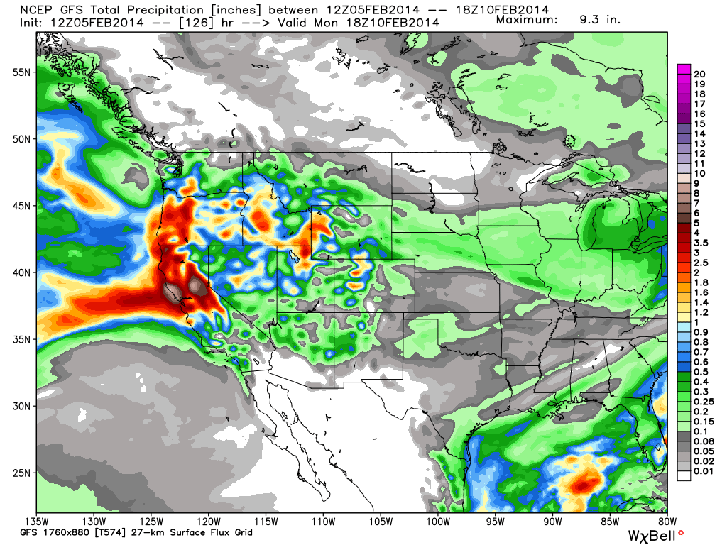
Not much of a break in precip Friday morning and light snow showers may continue especially along the crest before the next wave of moisture moves in. The GFS has come in line with the other models today in pointing the hose right at us as a moisture plume extends from Hawaii to Northern CA and sits there all weekend. That increases liquid amounts aimed right at Tahoe. The heaviest pushes of precip are expected Friday night into Saturday and again Sunday, with the precip finally tapering off by Monday morning.
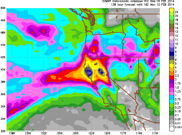
There is fairly good agreement in the model liquid outputs for the weekend in 2-3 inches of liquid for the East side of the basin, 3-4 inches for the West side, and up to 5 inches along the crest. Some locations in the foothills could see more than that. Some locations, like Tahoe City that has already picked up over 2 inches of liquid in 2014, could have picked up more precip in 2014 by Monday than all of 2013. This storm is going to be a blessing for the Northern CA drought. Let's take a look at the most recent model runs for total liquid through Sunday night.
GFS
Canadian
European
NAM
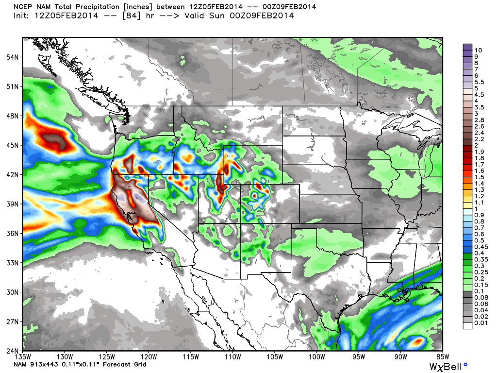
The interesting thing about the NAM is that it only goes through Saturday and has as much precip as the other models do through Sunday night.
So the complicated part of this storm will be the snow levels. The forecast models are in pretty good agreement that the snow levels will be down to lake level through Saturday morning. The European Control run looks the coldest through the weekend barely bringing snow levels above lake level Saturday night through Sunday. The European deterministic and GFS runs only bring them up to 6500-7000 ft. Saturday night and then back down to lake level Sunday night. The Canadian is the warmest right now bringing snow levels up to 7500 ft. by Saturday night before bringing them back down Sunday night.
With these pineapple express type events sometimes the models are colder than what actually happens and sometimes warmer. The last storm snow levels dropped faster than expected to lake level. They will start below lake level with the cold air in place this time and the question is when and how high they rise and when they fall in timing with the precip. The forecast above 7500 ft. where it is all snow is much easier. 20-30 inches East side of the lake, 30-40 inches West side of the lake, and up to 50 inches on the highest peaks along the crest by Monday morning. Below that is tricky. At lake level we could see 4-8+ inches Friday night into Saturday before snow levels come up, and then several inches at the end Sunday night. Between 6500-7500 feet anywhere from 1-3 feet depending on the snow levels.
Things clear out next Monday as the ridge builds off the coast with clear weather through Wednesday.
Long-Range:
The forecast models are trying to setup another series of storms the end of next week into the weekend. This time the storm track is further North. We may just be on the Southern edge of some systems with high snow levels. The European is the coldest and furthest South with a system the end of the week.
It looks like the storm track may shift North of us through about the 18th of the month before the ensembles hint at a deepening trough along the West Coast the last week of the month.
Stay tuned....BA
About Our Forecaster
Bryan Allegretto
Forecaster
Bryan Allegretto has been writing insightful posts about snow storms for over the last 15 years and is known as Tahoe's go-to snow forecaster. BA grew up in south Jersey, surfing, snowboarding, and chasing down the storms creating the epic conditions for both.
Free OpenSnow App


