Tahoe Daily Snow

By Bryan Allegretto, Forecaster Posted 10 years ago February 19, 2014
Summary:
Some light snow this morning has brought a coating of snow for most locations and possibly an inch or two to some of the mountains. A high pressure ridge will build in along the West Coast starting today through the beginning of next week. The ridge is forecast to shift North by the middle of next week as a large area of low pressure approaches the West Coast. The models are still in agreement that the jet stream breaks into the West Coast with a train of storms beginning next Wednesday continue into the extended forecast range.
Details:
Some readers are reporting an inch or two this morning as the weak cold front sweeps across the Tahoe Basin. There is limited moisture and the sun is already coming out here on Donner Summit. We only picked up a coating here at the office.
Now we are in the waiting period for a week. It is a good thing that the forecast is becoming like a broken record as the forecast models continue day after day to show the jet stream slamming CA next week. Consistency in the forecast builds confidence. It's all we really have to talk about between now and next Wednesday. The beginning of what may be a series of storms is entering the 7 day window as the GFS has sped up and now most model runs show precip arriving by late in the day next Wednesday.
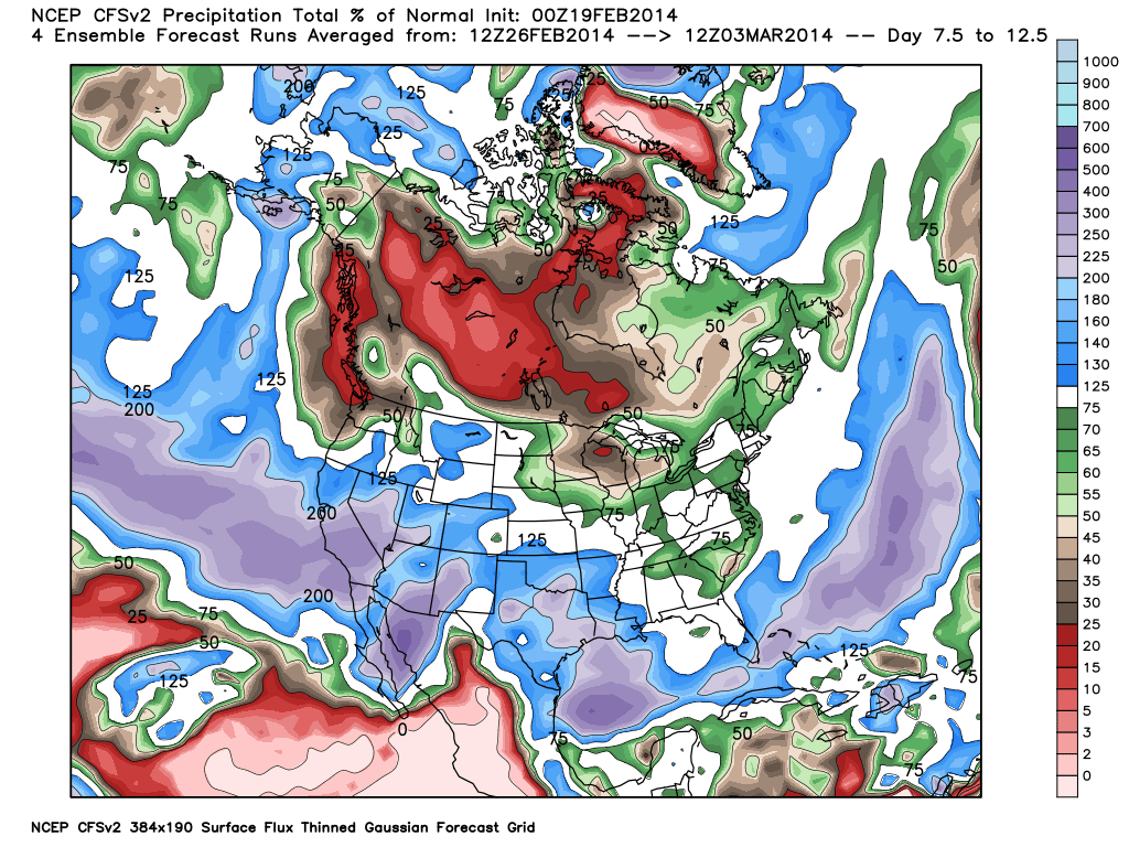
The ridge is going to shift North towards Alaska and Western Canada and the jet stream looks like it could finally break underneath into all of CA, not just Nortern CA. Here is the CFS % of average forecast for precip from 2/28-3/3.
We do have support from the MJO (Madden Julian Oscillation) forecast for the pattern the models are forecasting as it has become active in phase 6 and forecasted to move through phases 7,8,. If you go to the top of the page and click the "About" tab, on the left hand side of that page is the "Tahoe Info" link that will bring you to a page full of forecast maps including the MJO, PNA, and precip forecasts. I have not paid much attention to the MJO for forecasts this Winter because it has been forecasted to move through these phases before and we never saw any undercutting of the ridge, or the forecast was a bust as it would fizzle. This time the operational runs of the forecast models are showing an undercutting jet and the MJO is just agreeing it could help be responsible for the extension of the East Asian jet and a possible break through of the jet stream into CA next week.
Long-Range:
I don't want to over analyze any of this. I think we should just sit and wait a few days and then this weekend maybe start talking about some potential snowfall amounts if the forecast holds. The way the pattern looks to setup these storms should be just cold enough for mostly all snow with each system. Not looking like high elevation events but it's still far out.
The active pattern looks to continue into the first week of March. Beyond that the models are split between continuing an active pattern or ridging up again.
Stay tuned....BA
About Our Forecaster
Bryan Allegretto
Forecaster
Bryan Allegretto has been writing insightful posts about snow storms for over the last 15 years and is known as Tahoe's go-to snow forecaster. BA grew up in south Jersey, surfing, snowboarding, and chasing down the storms creating the epic conditions for both.
Free OpenSnow App


