Colorado Daily Snow

By Joel Gratz, Founding Meteorologist Posted 10 years ago March 2, 2014
Summary:
Steady snow for the southern mountains on Sunday morning, otherwise just brief snow showers for the rest of the state on Sunday. A few inches of snow is possible for the northern mountains on Monday evening, then a stronger wave will bring 3-6 inches to most mountains Tuesday night. An even stronger storm will bring 4-8" inches to many mountains on Thursday night into Friday. The best powder days this week will be Sunday morning (a few inches of fresh on Saturday's leftovers), Wednesday morning, and Friday morning/day (perhaps the best day). Next weekend will be dry.
Details:
Snow tapered off on Saturday night for most areas, but some bursts of steadier snow fell here and there on Saturday night adding a few fluffy inches. Most mountains will see a few snow showers on Sunday, and the southern mountains will see another 3-6 inches this morning, especially around Wolf Creek.
The next significant storm will bring 3-6 inches of snow to the central and northern mountains on Tuesday night, with snow potentially hitting the northern San Juans as well (Telluride, Silverton). It's possible that the mountains north of I-70 will see snow showers on Monday, Monday evening, and Tuesday in advance of the Tuesday night storm, but I have low confidence in this.
Wednesday and Thursday will be dry, then the strongest storm of the week will bring snow Thursday night through Friday will significant accumulations likely. Snow will favor the same areas as the Tuesday night storm (northern and central mountains, and north side of the San Juans). This storm will be colder that the past few storms, so the snow will likely be lighter and fluffier. Friday should be a nice powder day with 4-8+ inches for many areas. That said, there is still a lot of uncertainty with the track of this storm. The dipping lines over Colorado show the forecast for the storm on Friday morning. Notice the range of possible storm tracks, with the red line showing the average. In short, we know a good storm is coming, but the details are still up in the air.
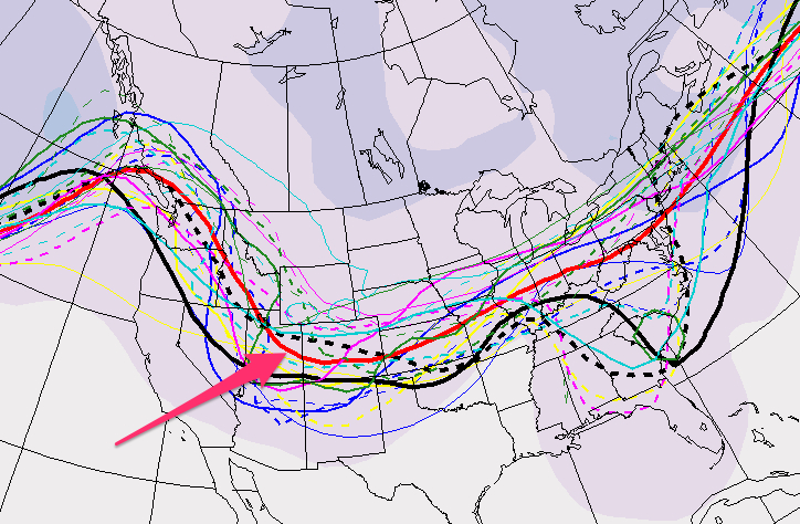
The Canadian model's spaghetti map of possible storm tracks for the Friday event. Source: Environment Canada
Friday will likely be chilly and snowy, and Saturday morning could be cold with leftovers. Then it will warm up and the sun will be out for most of Saturday and Sunday.
Long Range:
I have low confidence in the forecast for next week. It doesn't look like the entire week will be dry, and it doesn't look like we'll see multiple strong storms. Probably something in between, with three or four dry days and perhaps snow on one or two days. When the models gain a shred of consistency, I'll let you know.
JOEL GRATZ
> Checkout Liftopia for Discount Lift Tickets
PS - I had a great day out at Irwin Cat Skiing yesterday ... fun terrain and an absolutely first-rate staff and facilities. Looking forward to skiing Crested Butte today ... yellow jacket, blue helmet. Say hi!
About Our Forecaster
Joel Gratz
Founding Meteorologist
Joel Gratz is the Founding Meteorologist of OpenSnow and has lived in Boulder, Colorado since 2003. Before moving to Colorado, he spent his childhood as a (not very fast) ski racer in eastern Pennsylvania.
Free OpenSnow App


