Colorado Daily Snow

By Joel Gratz, Founding Meteorologist Posted 9 years ago August 25, 2014
Summary:
A slow-moving storm will bring clouds, rain, cool temperatures and high-elevation snow to Colorado this week. The wettest / coolest time will be from Tuesday evening through midday Thursday. Light snow accumulations will be possible over 13,000ft. The storm will move away by Friday night, then Saturday, Sunday, and Monday should be dry with average temperatures.
Details:
Late August and early September are usually pretty dry over Colorado. I remember moving to the state on August 15, 2003 and the weather was nearly perfect (blue skies, comfy temps) for the first month I was here.
However, the next week will not be typical as we'll see cool, cloudy, rainy, and perhaps even a bit of snowy weather.
On Monday morning, the water vapor satellite image below shows two interesting features.
First, there is a storm swirling over southern Oregon that is "cut-off" from the main west-to-east flow of weather. These cut-off storms move very slowly because they are removed from the faster winds of the jet stream to the north. The cut-off storm will slowly head toward Colorado on Monday, and then will be close to or over the state from Tuesday afternoon through Friday afternoon.
The second thing of note on the satellite image is the grey and blue colors moving from the Pacific Ocean, over southern California and Arizona, and into Colorado. These colors show medium to high amounts of moisture in the atmosphere, and when this moisture combines with the cut-off storm, Colorado will see lots of clouds and showers during the upcoming week.
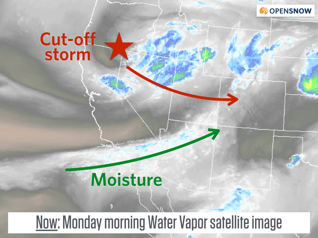
Source: Weathertap.com
As the cut-off storm approaches Colorado, expect showers over the eastern mountains on Monday afternoon, a break on Monday night, then a push of stronger showers and storms from midday Tuesday through Tuesday night. Rain showers will likely stick around for Wednesday and Thursday as well, with the chance for higher accumulations of rain on Wednesday and Thursday because the showers will move more slowly.
As for temperatures, the coldest air will settle over the state from late Tuesday night through Thursday morning, with readings cold enough for snow over about 13,000ft, and perhaps a bit lower. The forecast location of the coldest temperatures on Wednesday illustrate that the center of the cut-off storm will be over western Colorado, with a counter clock-wise flow of wind around the system.
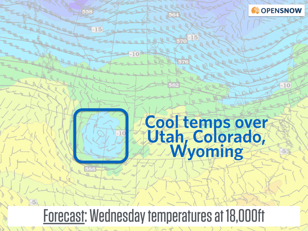
The main point of showing the temperature map is to notice how the circle of cold air (the storm) is cut-off from the main area of cold air to the north over Canada. The map is in Celsius, so -10C equals about 14F, and this is at 18,000ft. Source: Twisterdata.com
What does all of this mean for precipitation amounts?
Most models predict about a half an inch to an inch of rain for many areas. This won't be steady precipitation, so as usual in the summer months, some areas could see 2-3 inches while others see nothing at all.
Many mountains over 13,000ft should see a nice coating of snow with any showers from late Tuesday night through Thursday, so when the clouds give you a view, hopefully you'll see some snow-capped peaks:-)
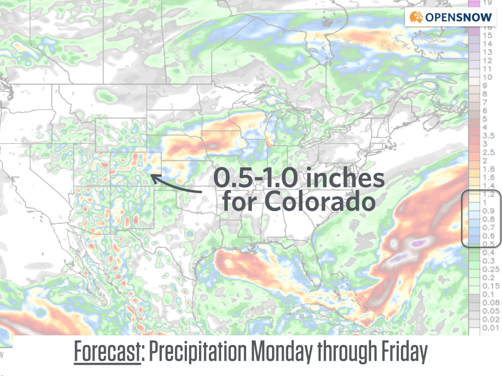
Colorado will be one of the wetter places in the country during the upcoming week. Source: Weatherbell.com
Then after a wet week, the all important Labor Day weekend forecast looks pretty good.
After a few remaining showers on Friday, our cut-off storm will finally move out of the state and we'll be left with perfect weather on Saturday, and most likely dry weather for Sunday and Monday as well.
We could see gusty winds and cooler temperatures on Sunday and Monday, especially for areas north of I-70 and east of the divide, but this all depends on the location of a storm that will cross Wyoming and Montana late in the weekend, so let's first focus on this week's cut-off storm and then I'll try to tighten up the weekend forecast in another few days.
JOEL GRATZ
About Our Forecaster
Joel Gratz
Founding Meteorologist
Joel Gratz is the Founding Meteorologist of OpenSnow and has lived in Boulder, Colorado since 2003. Before moving to Colorado, he spent his childhood as a (not very fast) ski racer in eastern Pennsylvania.
Free OpenSnow App


