Tahoe Daily Snow

By Bryan Allegretto, Forecaster Posted 9 years ago September 4, 2014
Welcome back.. I didn't get a chance to post in August although I have been watching and reading all of the Winter forecasts coming out and signals developing.
Our words of caution here at Opensnow since last Spring about El Nino not looking too strong for the upcoming season are now becoming relevant. The computer models this past Spring and early Summer once again tried to predict a Strong El Nino and many forecasters or media outlets took the bait and started hyping the upcoming season. Back in July I posted about taking caution in reading the early forecasts. Since then the forecast models have continued to weaken the outlook for El Nino this Winter, with the latest update from NOAA yesterday now saying only a 65% chance we even see an El Nino develop.
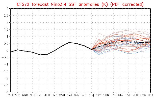
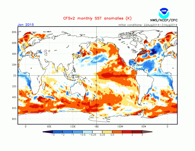
If one does develop it now looks to be weak at best. The good news is that we can now take the moderate El Nino years out of the analogs if the trend continues, and just look at weak events for now. The 4 ENSO regions this week are averaging 0.5c above average, just barely a weak El Nino signal. The ONI which is the 3 month average through July was only at 0.1. Still waiting to see the average through the end of August. The ONI would need to be at least 0.5 for 5 consecutive months in order to have an official El Nino event. Below is the latest CFS forecast for Nino 3.4 through the Winter peaking just barely above 0.5 now.
So now that the El Nino hype is gone let's look at some other factors that could affect the pattern this Winter. None of the things we will look at are for sure, but an entertaining look at possibilities using some things we know and trends from the past.
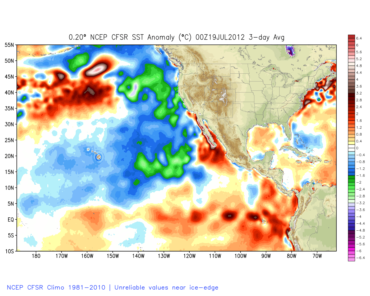
There was a warm pool of water in the Northeast Pacific last Winter and the warm water has now spread down the West Coast. That warm water was blamed for high pressure up in Canada last Winter that helped to send cold into the Central and Eastern U.S. The PDO (Pacific Decadal Oscillation) has flipped to a warm phase this Summer. That will change one of the variables we use in comparing past Winters in our analogs. Take a look at the sea surface temps 2 years ago in the Summer of 2012. Notice all of the cold water off the coast in a classice cold phase of the PDO look.
See the warm pool develop in the Northeast Pacific in 2013
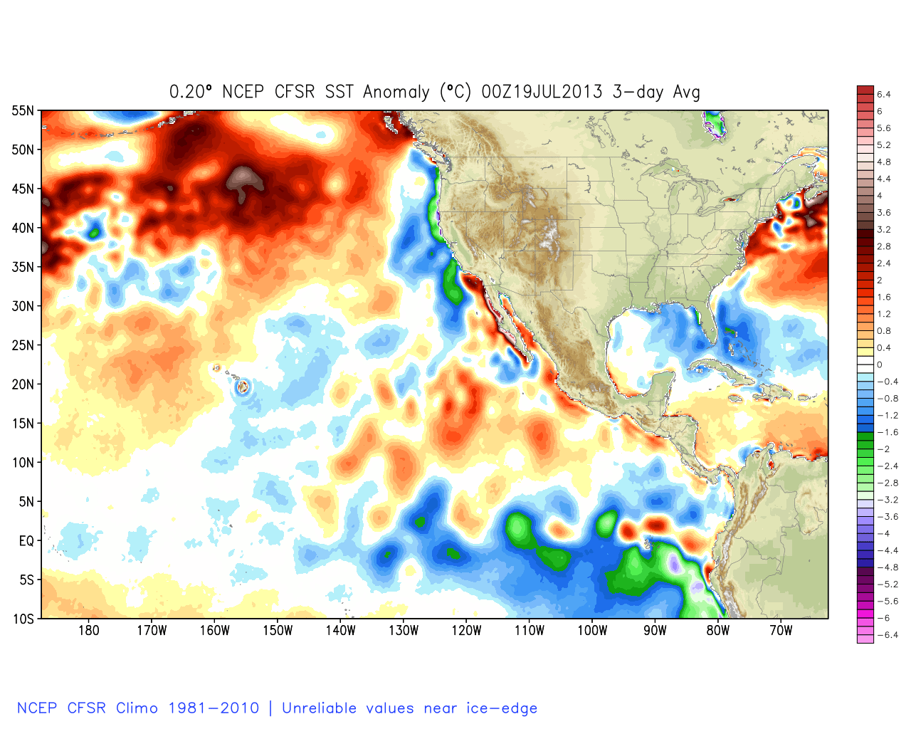
and now look at all of the warm water off the coast... With the look of a warm phase of the PDO.
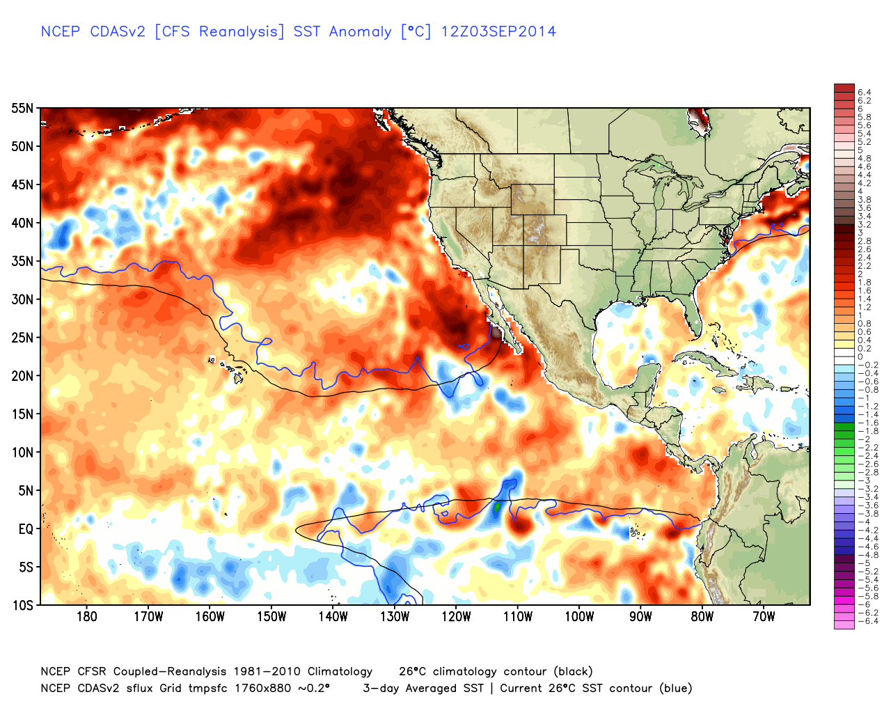
What is interesting is that the water down along the equator still has a lot of negative values which is why there is no clear El Nino signal yet. The forecast is for a Central Pacific modoki El Nino pattern to develop by Winter, if it does develop.
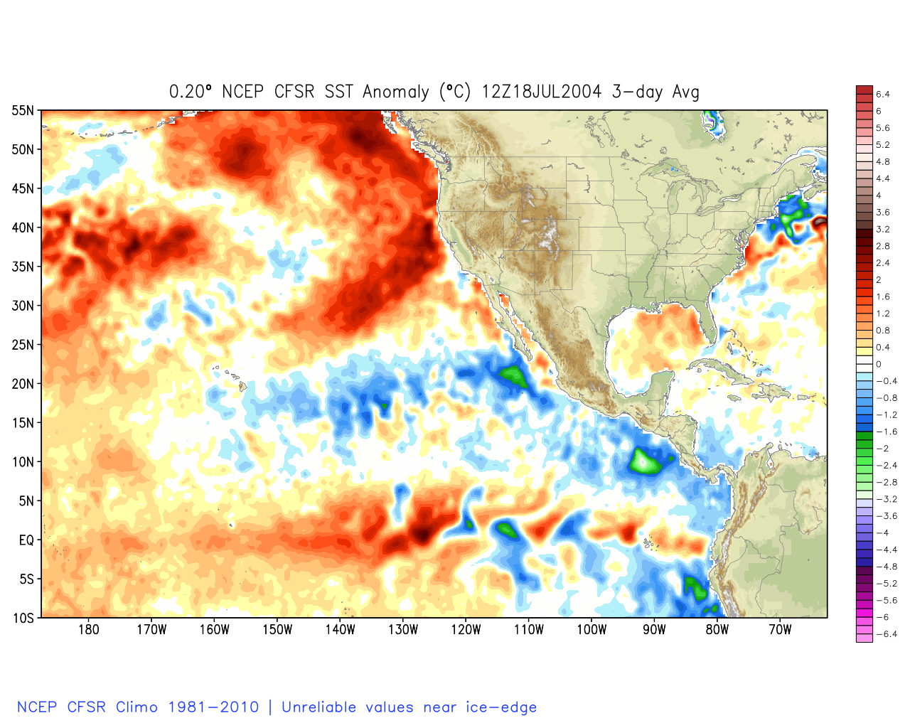
The warm water off the coast is most familiar in recent years to 2004 below. Biggest difference is the colder water off of Mexico. We will take note of that as we look at the analog years later in the post.
Another oscillation we can try to forecast this far out is the QBO (Quasi Biennial Oscillation). Looking at the latest readings it is currently in its Easterly phase and forecast to continue that way into the Winter. This is also the opposite of last season. So is it a good thing we have an opposite PDO and QBO compared to this time last year?. Most of you would probably take anything the opposite of last year as a good sign, but lots of warm water off the coast could mean a Western ridge again this Winter.
Let's take a look at some past weak El Nino seasons Oct-Apr, and the precipitation anomalies for them compared to the long-term averages. First, let's look at all of the weak El Nino seasons.
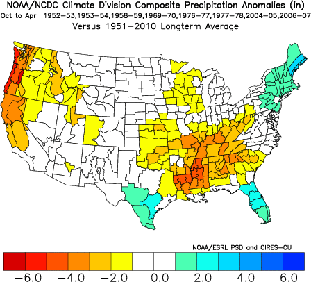
Not looking too good just based on the strength of the El Ninos alone. In comparison let's look at just the moderate El Nino seasons.
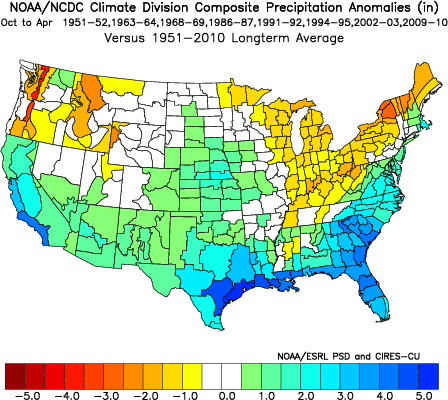
Now while these look much better there may be other factors that can split apart the moderate years as well between dry and wet seasons. Looking at the warm phase of the PDO years like we have now the average snowfall on Donner Summit is only 84% of average, while moderate El Ninos during a cold PDO are averaging 144% of average snowfall. So while a moderate El Nino as was possible when we looked earlier this Summer and may have increased our chance of an average season, with the warm PDO historically it may not have.
Now before I show you I can tell you that looking at the last 60+ years weak El Ninos in a warm phase of the PDO with an Easterly QBO phase like we could have this Winter, the average snowfall is very similar to a weak El Nino in a cold PDO and a moderate El Nino in a warm PDO phase. Below is the analog of the years that weighted the highest score when looking at these 3 factors this far in advance of the upcoming season.
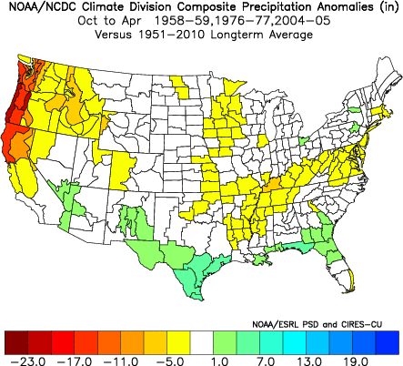
You can see the Southern jet stream is supressed well to our South with average precip for SoCal which is good news, and across the Southern U.S.
The only time Donner Summit runs above average for snowfall on average during weak-moderate El Ninos is during moderate El Ninos in a cold PDO. Maybe due to increased chance for West Coast troughing with the cold water off the coast.
The one thing with an Easterly QBO and the low solar activity continuing the country from the Rockies East could be very cold again this Winter, With above average snowfall in the Southeast.
The exact number for average snowfall at the Donner Summit snow lab is 323 inches or 84% of the 411 inch annual average during a weak El Nino in a warm PDO with an East QBO. The outlier is 2004-2005 which I mentioned above with when look at the sea surface temp comparison to this summer. The 04-05 season was a weak El Nino in a warm phase PDO with an Easterly QBO, but it had 482 inches of snowfall on Donner Summit at 117% of average. So yes, that year busts the analog average and is a possibility this year. (Thanks to Randall at the Snow Lab for all the data on Donner Summit snowfall)
These of course are only 3 factors and there are more that we will be able to look at as we get closer to Winter. Let's hope that we start to see some positive signs for the Winter. As I said this is just an entertaining way to look at the past and try to guess the future using it. It's not an exact science. Just like the forecast models change on a dime anything could happen this Winter. As of right now however, I am not seeing anything yet that is pointing towards a good chance of an above average snowfall this Winter.
Tis the season for looking at the forecast models more closely moving forward. We could see our first dusting on the mountains in September, it's not unusual here. Looking at the Fall for weak El Nino seasons they average 13 inches of snow in October, 26 inches in November, and 60 inches in December on Donner Summit. We do tend to start the season a little earlier. Despite being below average years they do have snow through the Winter. Let's hope we see it early and throughout this Winter!!!
Stay tuned.....more updates on Winter and the lookout for the first flakes coming soon.....BA
About Our Forecaster
Bryan Allegretto
Forecaster
Bryan Allegretto has been writing insightful posts about snow storms for over the last 15 years and is known as Tahoe's go-to snow forecaster. BA grew up in south Jersey, surfing, snowboarding, and chasing down the storms creating the epic conditions for both.
Free OpenSnow App


