Colorado Daily Snow

By Joel Gratz, Founding Meteorologist Posted 9 years ago September 16, 2014
Summary:
Mostly dry on Tuesday, Wednesday, and Thursday with a few afternoon showers over the San Juan mountains. The best chance of rain showers will occur between Thursday night and Friday night. Next weekend's weather is still tough to call, but I think it'll be on the drier side for most mountain areas in central and northern Colorado.
Details:
A few afternoon showers popped up over many of the mountains on Monday, but on Tuesday, Wednesday, and Thursday the majority of these showers should be confined to the southern mountains, generally south of US50 over the San Juans and Sangre de Cristo ranges.
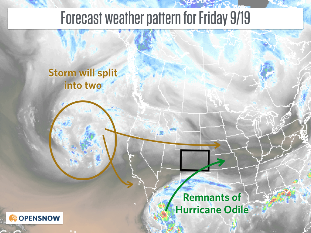
Our tranquil weather pattern will break down on Thursday night as the remnants of Hurricane Odile move toward Colorado from the south while another storm splits into two parts to our west, with one part heading for Colorado.
Between Thursday night and Friday night, look for cloudier weather with a good chance of rain showers and a few Thunderstorms.
During this time, the remnants of Odile will bring heavy rain to northern New Mexico and *maybe* to southern and southeastern Colorado, roughly from US160 south. There will be a limited path of heavier rain, and right now I'm not sure if this stays south in New Mexico or reaches up to southern Colorado.
Also on Thursday night through Friday night, part of the splitting storm to our west will move across northern and central Colorado, bringing an increase in showers and storms for most mountain and valley areas. This won't be an all-day soaking rain, but it will be a wetter day than Tuesday, Wednesday, and Thursday.
Basemap shows the Tuesday morning Water Vapor satellite image. Source: Weathertap.com
The big question is what will happen to the second half of the splitting storm to our west after Friday?
On the map above I show it heading south toward the southern coast of California. Since these splitting storms usually move very slowly, I'll side with the European model's prediction that it will stay over southern California through the weekend and won't move toward Colorado until Tuesday of next week. This is about 1-2 days slower than the American GFS model's forecast.
Siding with the European makes our weekend look mostly dry over the northern 2/3rds of the mountains, with just a few showers over the San Juans and some cooler, perhaps cloudier weather over the eastern plains. In short, the European model says it'll be a nice weekend to look at the early fall color in the northern half of Colorado, while the American GFS model says it'll be wet for a lot of the weekend. Again, I'll side with the Euro since splitting storms usually move very slowly.
Lastly ... a quick look at the long-range forecast shows the possibility of a cooler system affecting northern Colorado and areas east of the divide during the last 3-5 days of September. I'll keep ya posted ... don't put too much confidence in 10 day forecasts:-)
JOEL GRATZ
About Our Forecaster
Joel Gratz
Founding Meteorologist
Joel Gratz is the Founding Meteorologist of OpenSnow and has lived in Boulder, Colorado since 2003. Before moving to Colorado, he spent his childhood as a (not very fast) ski racer in eastern Pennsylvania.
Free OpenSnow App


