Colorado Daily Snow

By Joel Gratz, Founding Meteorologist Posted 9 years ago October 25, 2014
Bit of snow Sunday night, then cooler Mon & Tue
Summary:
Sunny and dry on Saturday, more clouds and breezy on Sunday, a few inches of snow for northern Colorado on Sunday night, then dry and cooler on Monday and Tuesday with warmer weather for later next week.
Details:
Saturday will be much like Friday with sunny skies and temperatures 10-20 degrees above normal.
On Sunday there will be a few more clouds and the wind will kick up in the afternoon, especially for areas along and north of I-70. This is in advance of a cold front that will push through on Sunday night.
The storm on Sunday night into Monday morning will be weak and moisture-starved, so the best we can hope for is a few inches of snow along a heavier band for areas around Aspen and north to I-70 and Steamboat. The snow level will start around 11,000ft before the band and then lower to 7,000-8,000ft on the tail end of the event.
Monday and Tuesday will be much cooler than the weekend, so snowmaking teams will be able to crank the guns. This cooler air is really just a return to average temperatures for late October.
Temperatures will then warm back to about 10 degrees above average by the middle and end of next week, though it'll still be cool enough overnight for some snowmaking to continue.
Our next chance for a storm will be around November 3-5, but at this point it looks more like a marginal event rather than the big kahuna.
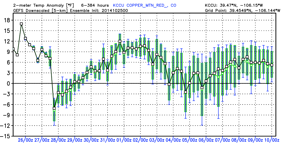
Putting all of this together into one chart, the image below shows the American GFS model's temperature forecast compared to average for Copper Mountain (a good representation of northern Colorado).
The thick horizontal black line in the middle shows average temperatures, with temperatures above that line being above average. You can see Saturday and Sunday's above average temperatures, a return to average or just below on Monday and Tuesday, then a warm up through early November until our next chance for a storm cools things off around November 3-6. The thin black line is the model's best guess while the bars show other possibilities. The further out in time (toward the right), the wider the range of possibilities.
Have a great Saturday folks ... yesterday's comments revealed a lot of folks who shared my Pennsylvania roots which was fun to see!
JOEL GRATZ
About Our Forecaster
Joel Gratz
Founding Meteorologist
Joel Gratz is the Founding Meteorologist of OpenSnow and has lived in Boulder, Colorado since 2003. Before moving to Colorado, he spent his childhood as a (not very fast) ski racer in eastern Pennsylvania.
Free OpenSnow App


