Colorado Daily Snow

By Joel Gratz, Founding Meteorologist Posted 11 years ago October 16, 2012
I'm almost happier than a witch in a broom factory.
I'm almost happier than Eddie Money running a travel agency.
Why, you might ask? Because there's actually storminess to talk above over the next two weeks. Wahoooo! After last season's dismal performance, boy does it feel great to have something interesting to forecast.
There are four things coming up for Colorado over the next 10 days:
1) Windy today through Thursday morning
2) Quick shot of snow tonight, mostly for I-70 and north
3) Possible Monday snow, but it depends on Hurricane Paul
4) Likely storm late next week (October 25-27)
1) First, the wind.
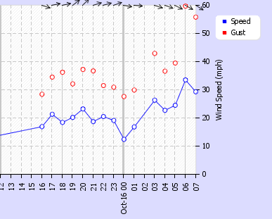
It's already gusty, with a 60mph gust reported at 6am Tuesday morning on Loveland Pass. Look for the red dot at the top of the image at 6am.

The Jet Stream (an area of very strong winds at about 30,000ft in the sky) will cover the northern half of Colorado from Tuesday midday through Thursday morning. Some of these winds will "mix" down to the surface, so Tuesday will be breezy for many areas. The windiest times will be late Tuesday night through Wednesday night along the continental divide north of I-70 (especially Rocky Mountain National Park area) when wind gusts could easily be over 60mph. Some of these winds will also make it breezy on the plains and urban areas on Wednesday.
2) Quick shot of snow Tuesday night
A fast-moving cold front will sweep across Colorado from north to south on Tuesday night. The bummer is that most of the moisture will fall before the colder air arrives, so snow levels are going to be very high (11,000ft) though heavier snow showers could drive snow levels a bit lower. A narrow but intense band of snow could form along the leading edge of the cold front, with snow (lower elevation rain) for the Steamboat area between 6pm-9pm, snow/rain for I-70 areas from 8pm-midnight, and a few lighter showers making it down to the northern San Juans around Telluride and Silverton by about 3am. All snow/rain will be gone by sunrise and temperatures will be much chillier on Wednesday...about 15 degrees cooler than Tuesday, actually. The deepest snow should fall along the continental divide north of I-70 (also the area of strongest wind), but "deepest" is relative as it will likely stay below 4 inches.
3) Possible Monday storm?
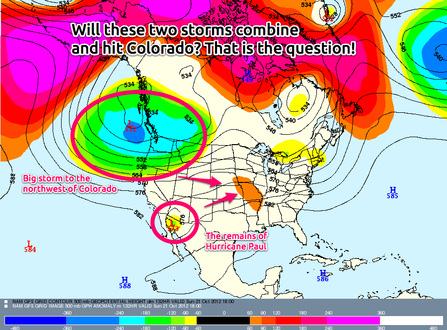
The models are all over the place concerning our storm potential on Monday. Why can't they get their act together? It's because of hurricane Paul, churning near the Baja Penisula with winds over 100mph. The eventual path of Paul will determine if we get a storm dropping south into Colorado on Monday or if the storm stays to our north and we get nothing. Here's the storm and Paul's position on Sunday night:

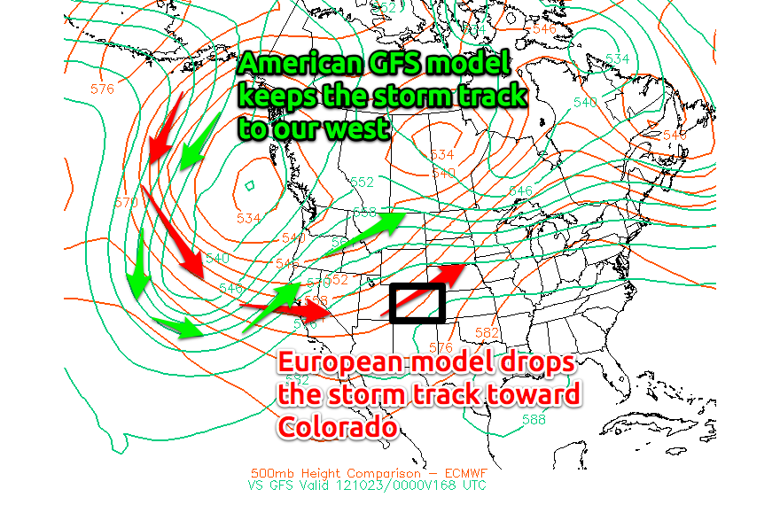
Check this out. The American GFS model thinks that Paul won't help us at all and the storm will stay to our north and west. The European model (and a few others) think the storm will drop further south into Colorado will Paul pulling it down. Hopefully we will know more in a few days...this uncertainty is killing me, but it's part of the weather game.

4) Likely storm late next week (Oct 25-27)
Even though the models are having issues with their six day forecast for next Monday's storm, they have a lot of agreement about the 9 day forecast with a colder storm hitting Colorado sometime next Thursday, Friday, or Saturday. The details will of course be filled in later, and I hate long range forecasts, but this one looks pretty good. And last storm we had (Friday & Saturday, October 12-13), the models predicted about 7-9 days out, so sometimes there is an ability to predict the long range. Sometimes:-)
I'm off to tour DIA's Operations Center with the weather team from Channel 7 News. We're hoping to team up with Channel 7 to help DIA with some snow forecasting this winter! And as a huge aviation nerd, I'm pretty excited:-)
JOEL GRATZ
PS - what do you think will happen with the Monday storm? Will it hit or not? Discuss below!
About Our Forecaster


