Colorado Daily Snow

By Joel Gratz, Founding Meteorologist Posted 11 years ago December 15, 2012
- Update 845pm -
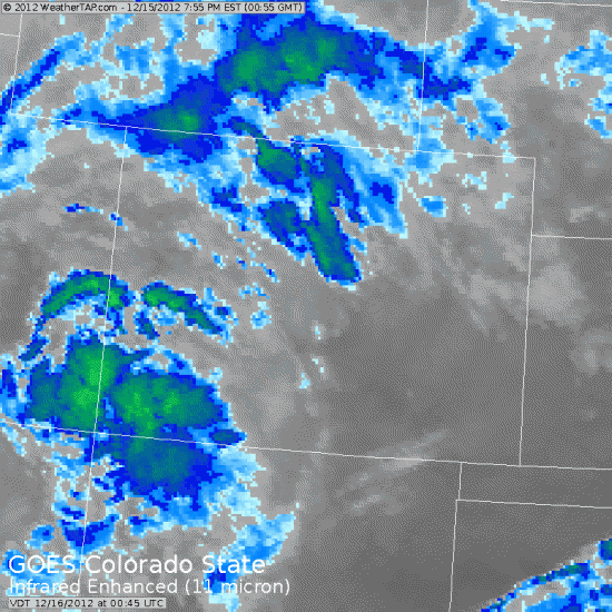
A piece of storm energy (vorticity) is moving from west to east across southern Colorado right now. You can see the batch of clouds on the satellite image below. This is cranking out a bunch of snow right now over southern Colorado and I think Wolf Creek will have another sensational powder day tomorrow (the third in a row).

- Previous discussion from 800am -
We're back to winter and it feels great. Yesterday's storm nailed the San Juans, we'll see snow off-and-on through the weekend, and next Wednesday will be a powder day for the entire state! Let's get to the details...
Yesterday's storm (Friday) hammered the southern San Juans as advertised with Wolf Creek reporting 21" storm total and 13" at Durango. As the wind switched to the west other mountains saw better snowfall late in the afternoon and in the evening, but I'm disappointed that this only squeaked out a general 2-4". I was hoping for an inch or two more than this, but as I said earlier the series of storms this weekend is tricky as the energy is spread out over a few different weak storm centers.
Snow will continue Saturday, Saturday night, and Sunday as moisture hangs out over the state and the weak storm centers move through every 12 hours or so. Once again the southern San Juans will be favored today (Saturday), though the rest of the state should see a few more inches, especially this afternoon and Saturday night. Snow will stick around on Sunday and Sunday night for the northern half of the state as the last in the series of storms crosses this area. I wish I could provide a more detailed forecast of snow amounts and timing instead of broad brushing the forecast with a general 1-2" here and there, but this is the difficultly with a pattern where there is NOT one strong storm center but instead a bunch of weak ones.
The next storm will be a big one and it'll make Wednesday a powder day for the entire state. A strong cold front will push in from the west Wednesday morning (ish). Before the cold front snow will hit the southern San Juans hard, and then once the cold front passes, the entire state will see heavy snow. Wednesday will be a snowy and powdery day for almost all locations. I'm going out on a limb here and marked Wednesday (the fifth day in the forecast) as a powder day at every resort (see the blue box on the forecast grid). While the amounts will change as the day gets closer, all models agree that Wednesday is the deepest day of the next week. Hopefully your boss will understand that you just can't make it in that day. You've got a fever, and the only prescription is more cowbell...
The site was very slow (or perhaps you couldn't even load it) yesterday morning. The reason is that we saw way more traffic than we ever had. Growing pains! Here are more details about the issue and what we're doing to ensure the site loads for everyone, every time.
Enjoy the powda, present and future!
JOEL
About Our Forecaster


