Tahoe Daily Snow

By Bryan Allegretto, Forecaster Posted 10 years ago February 24, 2014
Summary:
Sunny and mild weather today and Tuesday with highs in the 50's. The pattern changes on Wednesday as the first storm begins to push in precip by afternoon. The heaviest snowfall pushes in Wednesday night as snow levels drop from 7000 ft. to below lake level. Snow showers last into Thursday. Expecting 3-6 inches at lake level, 6-9 inches above 7000 ft. on the East side of the basin and 9-12 inches on the West side. A foot or more possible West of the lake along the crest.
The next storm pushes in by Friday morning with snowfall lasting through Saturday night. This system does not have as much forcing for snowfall to push over the crest into the Tahoe basin. Even though it lasts 36-48 hours we may only see the same snowfall amounts as the first system. On Sunday we may see scattered snow showers before a third wave of precip pushes in Sunday night into Monday. The forecast models do not agree on how strong this wave is. Some show light snow showers and others show the potential for another foot of snow.
One last wave will try to push in Wednesday or Thursday of next week as the ridge begins to build along the West Coast. Then we go into a drier pattern. Some models hint at the jet stream breaking into CA after the 10th of March while others keep the dry pattern going.
Details:
Not too many changes in the short-range with the first two systems. Still looking at the same snowfall amounts as the last several days as mentioned above. The second system is more interesting for mountains along and West of the crest. Models show 2-3 inches of total liquid along the crest West of the lake and much less into the basin without good forcing as the main storm track and jet stream are to our South. Just West of the crest on the Western slope and foothills the models show several more inches of liquid. Mountains that stick out further West on the Western side of the passes like Sugar Bowl and Kirkwood may pick up more snow than forecasted.
Right now total snowfall for the 5 day period is not that impressive with 6-12 inches at lake level, 12-18 inches above 7000 ft. on the East side of the lake and 18-24 inches on the West side. Along the crest 24-30 inches but just West of the crest more is possible. 2-3 feet on the mountains in 5 days is not a lot but we'll take it. Snow levels look to start around 7000 ft. Wednesday afternoon but fall below lake level Wednesday night. They may rise just above lake level during the break Thursday night and then fall back below lake level Friday with the second system.
The GFS has another weak wave moving in Sunday as some colder air pushes down from the North. That keeps snow showers going. It then dries things out. The Canadian brings a third wave in Monday with a few more inches of snowfall. The European model is the most agressive with a third wave on Monday that pulls in some moisture off the Pacific. The Euro brings in enough liquid for another foot of snow for the mountains. We'll have to wait for some more agreement in the next few days to get a better idea on the third system.
Here is a look at the European total precip forecast through next Monday. It has enough liquid for 3-4 feet of snow along the crest by next Tuesday with the 4-5 inches of liquid line just West of the crest and 5-6 inches for the foot hills.
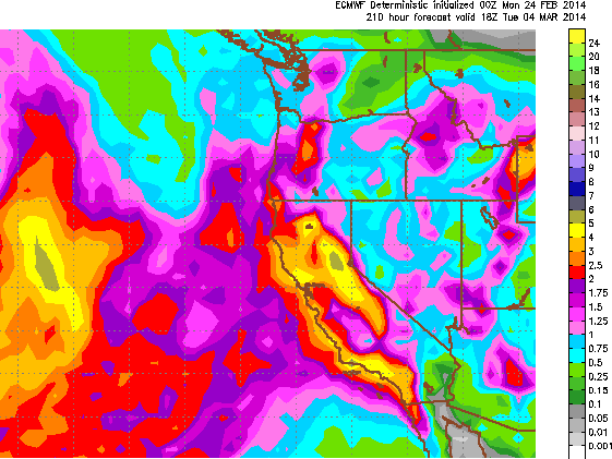
The European is the strongest with the total precip forecast through next Monday. We should expect the lesser amounts but hope to be surprised if the Euro is right.
Long-Range:
The forecast models continue to diverge in the long-range. The GFS keeps the ridge along the coast fairly flat through the extended and tries to push systems through the ridge into Northern CA every couple of days starting next Thursday. The Canadian and GFS ensemble runs hint that the trough in the Pacific moves East towards the West Coast beyond the 10th of March bringing back a stormy pattern. The European model shows the ridge building in up the West Coast next week with dry conditions. The ensemble runs show the trough in the Pacific staying North to Northwest of Hawaii and the ridge along the West Coast with dry conditions through the extended.
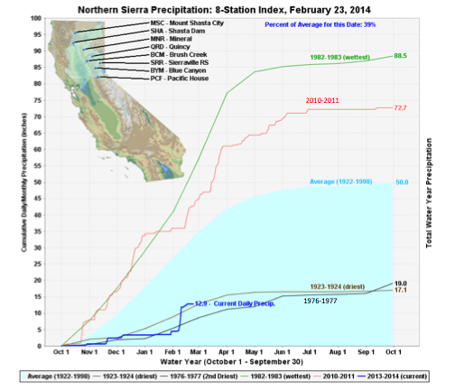
Looking at the precip totals we have been tracking near the driest water years 76-77 & 23-24, as well as with snowfall. The last storm gave us a boost with precip and the ones this week should give us another boost. Still a dry year but possibly not the driest after this week.
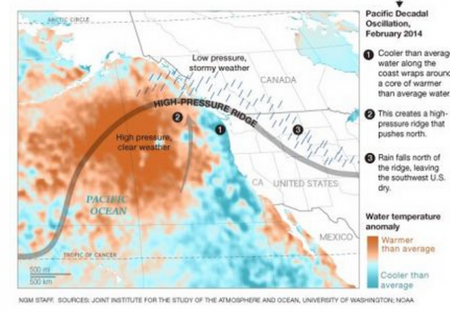
There is no one thing you can point to and blame for the dry Winter. There are several factors keeping storms away from CA. Here is one that has not been helping.
Stay tuned...BA
> Checkout Liftopia for Discount Lift Tickets
About Our Forecaster
Bryan Allegretto
Forecaster
Bryan Allegretto has been writing insightful posts about snow storms for over the last 15 years and is known as Tahoe's go-to snow forecaster. BA grew up in south Jersey, surfing, snowboarding, and chasing down the storms creating the epic conditions for both.
Free OpenSnow App


