Tahoe Daily Snow

By Bryan Allegretto, Forecaster Posted 10 years ago February 26, 2014
Summary:
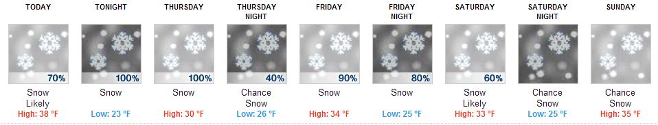
An active weather pattern begins today. Precipitation is currently pushing into CA. We should see snow begin to fall West of the lake up along the crest by afternoon. As precip pushes into the Tahoe Basin later this afternoon and evening the snow levels will start around 7000 ft. Snow levels should fall to lake level around midnight. The heaviest snow will fall overnight with snow showers lingering through most of the day on Thursday. By Thursday evening we should see 3-6 inches at lake level, 6-9 inches above 7000 ft. East of the lake, 9-12 inches West of the lake, and up to 15 inches above 8000 ft. West of the lake along the crest. The best chance for the highest totals will be on the South side of the lake.
The next storm moves in Friday morning. The strongest part of this storm will be moving into Southern CA, but we will still see some decent snowfall. The snow should begin to taper off Saturday morning. This storm will have snow for all elevations. We could see another 5-10 inches on the East side of the lake, 10-15 inches on the West side, and 15-20 inches West of the lake up along the Sierra crest.
We should see a break on Sunday. The forecast models diverge on the strength of subsequent systems next Mon-Tue and again Wed-Thu. We could see any thing from a few more inches to a few more feet. We will watch that closely. Then a dry pattern by the end of next week into the following weekend. Models hint at another wet pattern beginning around the 11th.
Details:
The snowfall forecast over the past week has been like a broken record, as well as the forecast for this storm series over the last 2 weeks. The forecast models did really well forecasting this pattern change a couple of weeks ago, and have been in very good agreement and consistency in snowfall amounts the last several days. Lots of positive things to talk about today in the short and long range. You have to love the 5 day forecast image for 8k ft. Olympic Valley.
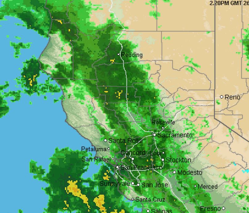
Looking at the current radar you can see that the precip associated with the first system is already pushing into CA.
We could see light snowfall on the crest as early as later this morning. The precip stays light until this evening when the cold front begins to approach the coast and heavier precip pushes in. Snow levels will start around 7000 ft. today and may stay there until later this evening when the front approaches. Looking at the latest model runs it looks like the snow levels fall below lake level around or just after midnight. The heaviest snow looks to fall between 10 p.m. and early Thursday morning. The snow showers behind the front look like they could last most of the day on Thursday before tapering off by Thursday evening. Highest winds look to only be gusts up to 50 mph on the highest peaks Thursday before waning.
Total snowfall still looks to be around 3-6 inches at lake level, 6-9 inches above 7000 ft. East side of the lake, 9-12 inches West side, and up to 15 inches West of the lake up along the crest by Thursday evening. With the jet stream to our South the potential for the higher end of the snowfall forecasts for this storm and the next will be on the South side and South of the lake.
We should see a break in the precip Thursday night as the next system pushes into Southern CA. The storm has a large area of precip that looks to push far enough North to bring another round of snowfall Friday into Friday night. Southern CA will take the brunt of this system. The snow levels will start low with this second system with snow for all elevations. The snow showers may linger into Saturday morning but look light and should taper off by afternoon. Winds may gust 30-40mph but they don't look that strong with the jet stream well to our South.
If the jet stream was aimed furthern North at Central CA we would most likely see triple the amount of snow. Snowfall amounts look similar to the first system, maybe a few inches higher especially South of the lake where we should see the higher end of the snowfall forecast. Total snowfall by Saturday morning looks to be around 5-10 inches on the East side of the lake, 10-15 inches on the West side, and up to 20 inches West of the lake up along the Sierra crest. 3 day totals by Saturday could be around 8-16 inches at lake level, 11-19 inches above 7000 ft. on the East side of the lake, 19-27 inches West side, and 27-35 inches West of the lake above 8000 ft. along the Sierra crest. Again, best chance for the higher totals on the South side of the lake.
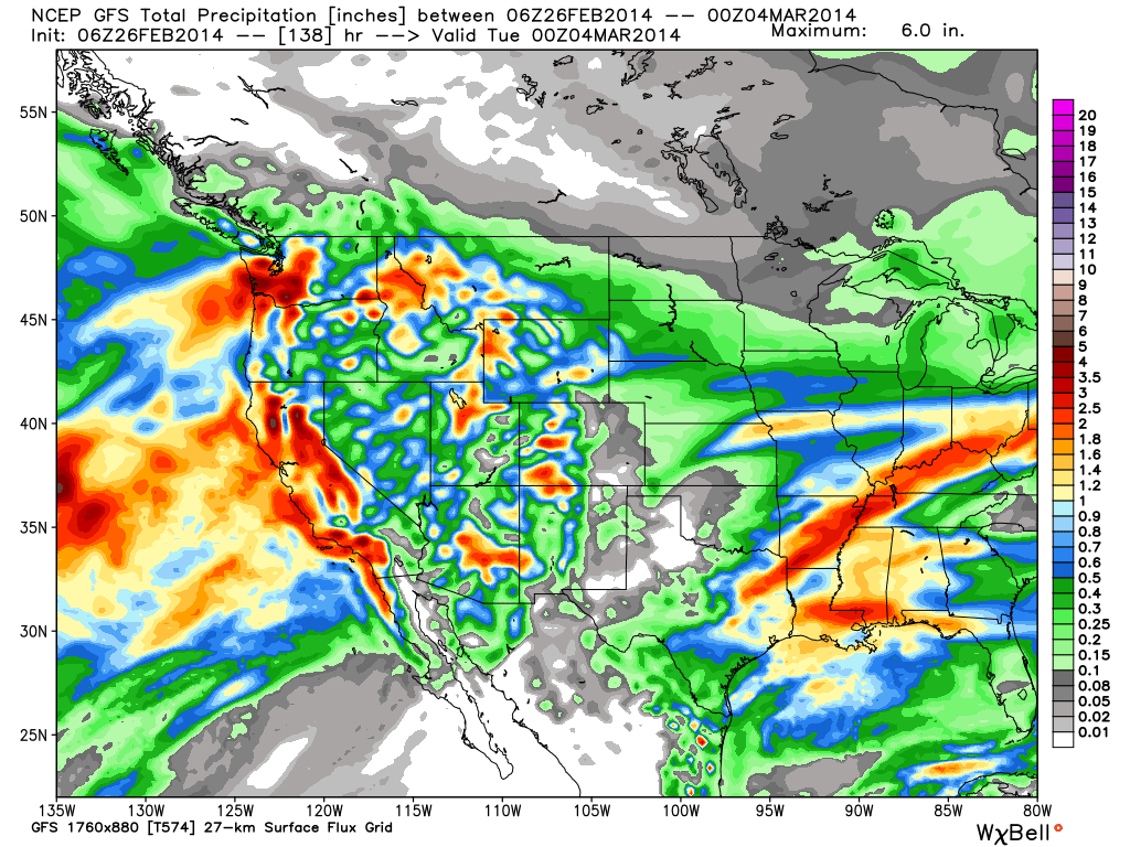
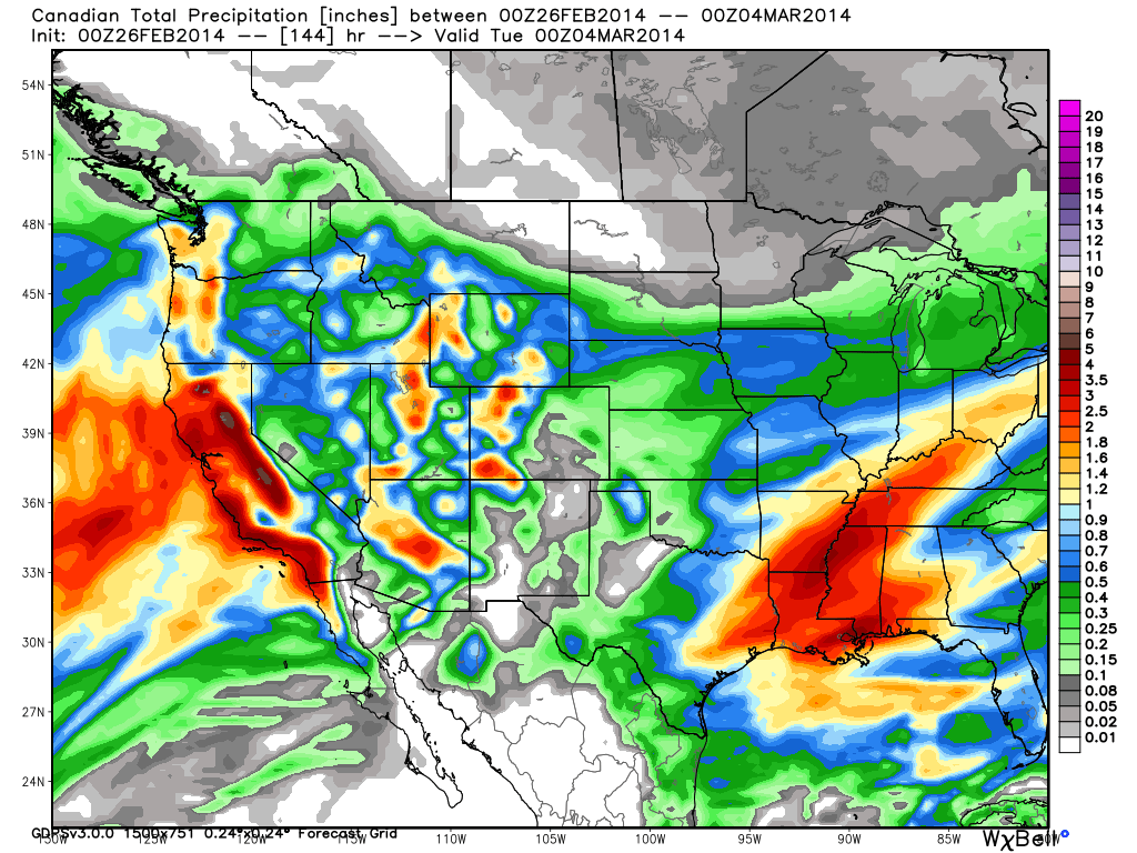
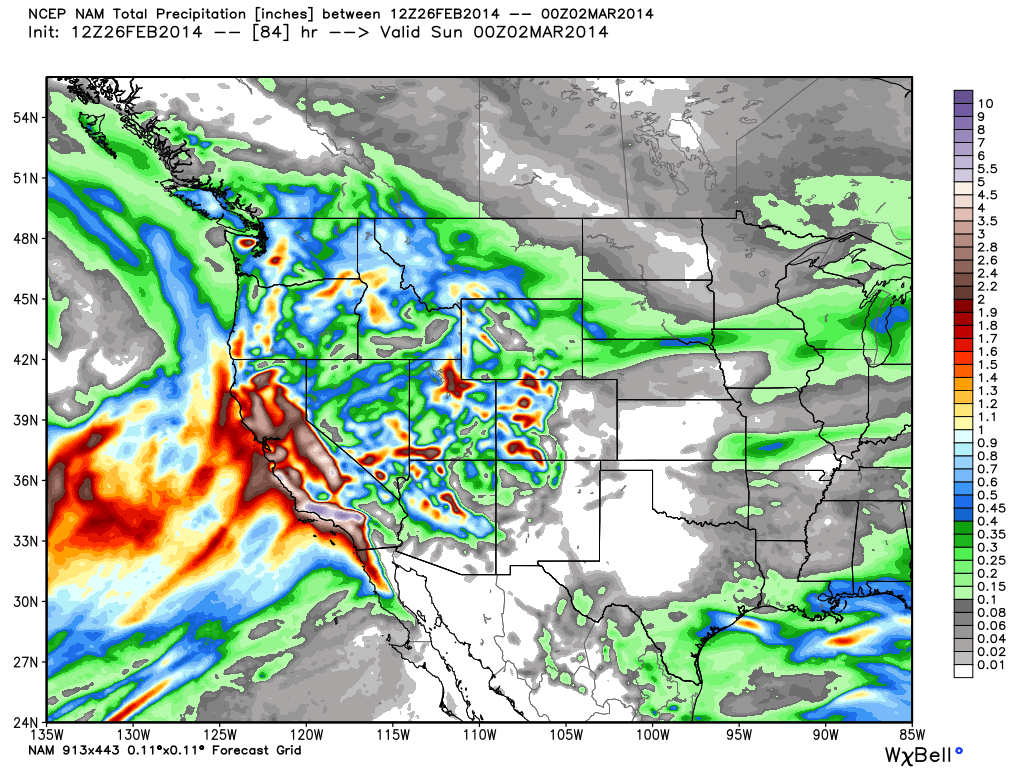
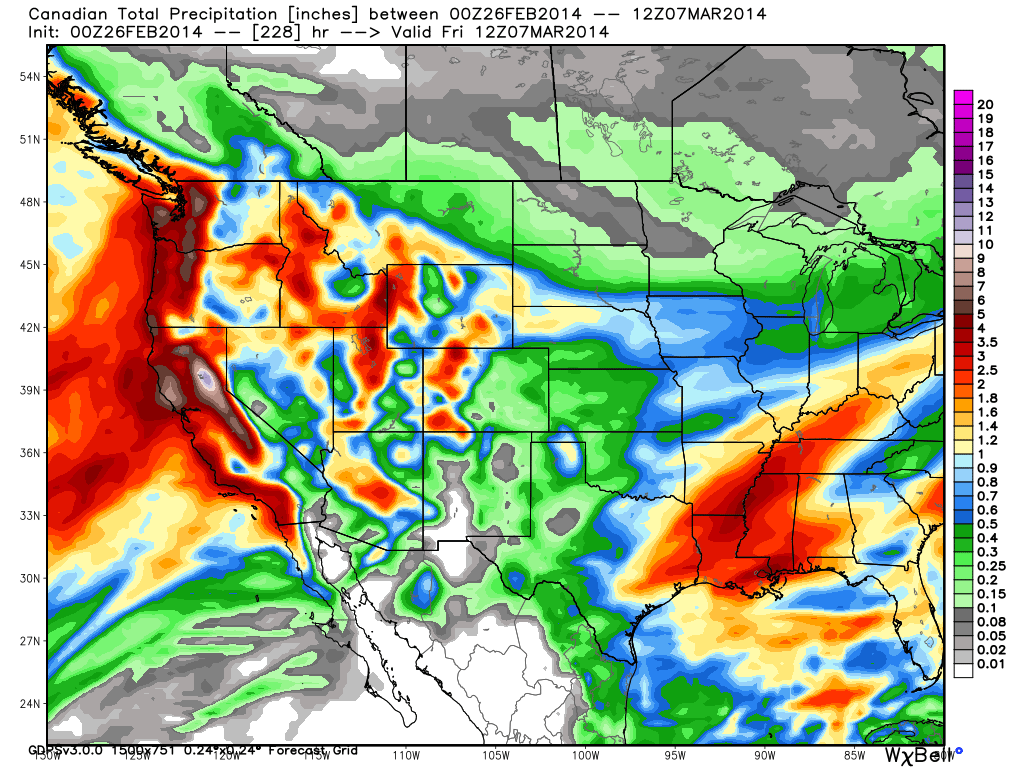
Looking at the total precip forecasts they are all very similar.
GFS
Canadian
NAM
It looks like we will see a break in the action later Saturday through Sunday. The next system pushes into the West Coast Monday into Tuesday with another one on its heels for Wednesday into Thursday. The forecast models have been trending in a positive directions the past 24 hours. The GFS that had the ridge building in with dry conditions next week now has a flatter ridge with the storm track just to our North, and light amounts of precip trying to make it into the Tahoe basin with each system. The Canadian model now shows both systems bringing in a decent shot of snowfall, especially the Thursday system. The European model continues to show both systems bringing in decent amounts of snowfall.
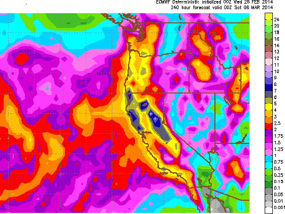
Being that these systems are in the 5-7 day window and the forecast models are trending in the right direction, confidence is increasing that we will at least see a little snow each day Monday through Thursday. If the European and Canadian models are right we could see another 1-3 feet over the Tahoe basin and 2-4 feet along the crest. So we will definitely be watching the trend over the next few days. Here are the total precip maps from both through the end of next week.
Canadian
European
Long-Range:
The models are in agreement that we go into a dry pattern by the end of next week from the 7th - 10th of March. The trough shifts West from the East Pacific to North Northwest of Hawaii and South of the Aleutian Islands. The ridge then builds along the West coast pushing the storm track up into Canada. A pattern we are familiar with this season. The GFS has been showing the trough shifting back into the Eastern Pacific by the 11th for several days, with storms returning to CA. The Canadian ensemble runs started to support that idea yesterday, and today the European ensemble runs show it as well. As we know anything 2 weeks out is not very accurate, but the models are starting to agree and trend in the right direction. That is increasing the odds we do see a shift back to a wet pattern from the 11th and into mid-March.
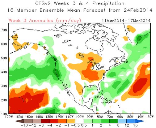
The CFSv2 climate model is seeing something positive as well for the 11th-17th of March.
So fingers crossed as we may see snow off and on for the next 8 days, a short dry pattern, and back to a snowy pattern if everything works out. It would be nice to see Winter finally show up in March. It wouldn't take much to make March the snowiest month of the season.
Stay tuned....BA
> Checkout Liftopia for Discount Lift Tickets
About Our Forecaster
Bryan Allegretto
Forecaster
Bryan Allegretto has been writing insightful posts about snow storms for over the last 15 years and is known as Tahoe's go-to snow forecaster. BA grew up in south Jersey, surfing, snowboarding, and chasing down the storms creating the epic conditions for both.
Free OpenSnow App


