Tahoe Daily Snow

By Bryan Allegretto, Forecaster Posted 9 years ago March 2, 2015
One Hit Wonder....
Summary:
Cold temperatures today through Tuesday as a cold splitting system drops a piece of energy down to our West and East today into tonight. We could should see snow showers today on the mountains West of the lake along the crest. Tonight we could see showers along the East side into Reno. By Wednesday high pressure builds in with dry weather for a week. It looks like a storm stalled off the coast this weekend will eject inland to our North by next Tuesday. Behind that a cold trough could push a storm through the area the 2nd half of next week. After that there are a lot of questions as to what the pattern will hold for us.
Details:
There is a low quickly spinning down the West coast today from a splitting system. Snow showers have started to form this morning West of the lake along the crest. This is the area that could pick up 1-3 inches of snow today on the mountains. The snow could fall in quick bursts of heavier snow showers.
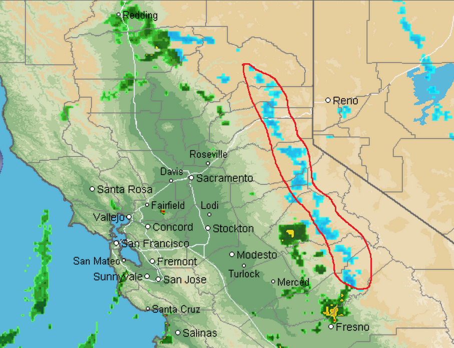
Across the basin sun and light scattered showers could bring a dusting to some areas. We already picked up a quick dusting of snow this morning in South lake from a passing shower, and reports in King Beach of a couple of inches this morning from a heavier band. Tonight the other piece of the splitting system drops down to our East through Nevada. That could bring a dusting of snow to the mountains on the East side of the basin.
High pressure builds in by Wednesday as temperatures begin to warm. By this weekend highs will be into the 40's on the mountains and 50's at lake level with lots of sun, continuing into the beginning of next week.
Long-Range:
As I cautioned yesterday the European was showing the ridge holding the beginning of next week and the GFS tends to be too quick to push troughs in. This morning the GFS has changed in line with the Euro showing the system stuck off the coast ejecting inland next Tuesday to our North with nothing for us. The trough dropping down from Alaska helping to push the system inland may push into the West Coast the 2nd half of next week. That may be our next chance of snow, 9-10 days away....
What continues to be interesting this season is that the climate models continue to show the next 30 days above average for precip... Some conflicting signals emerging in the long-range so a lot of uncertainty with where the pattern is going in March.
Feb Recap:
Speaking about above average precip forecasts, February actually ended up being above average for precip for the Tahoe and Truckee river basins, as well as much of the Northern Sierra thanks to the big rain storm a couple of weeks ago. The Tahoe basin ended up with 162% of average precip for the month of February bringing us up to 62% of average for the water year.
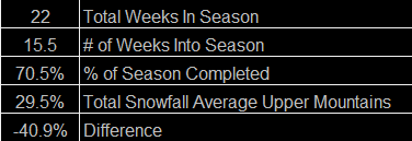
Looking at the snowpack there is a big discrepancy as the big storms this season have been high elevation until this week. The snowpack after this latest storm is sitting at only 20% of average for the Central Sierra.
There is a discrepancy on the resort totals up top for the season as well even with the higher elevation. Here is my chart of reported snowfall at the summits vs. where we are in the season.
About Our Forecaster
Bryan Allegretto
Forecaster
Bryan Allegretto has been writing insightful posts about snow storms for over the last 15 years and is known as Tahoe's go-to snow forecaster. BA grew up in south Jersey, surfing, snowboarding, and chasing down the storms creating the epic conditions for both.
Free OpenSnow App


