Tahoe Daily Snow

By Bryan Allegretto, Forecaster Posted 9 years ago March 4, 2015
Something's Trying to Brew...
Summary:
Still some cold air hanging on today with high's in the 30's on the mountain and 40's at lake level. Overnight lows were cold last night in the valleys. High pressure building in will warm high temps another 10 degrees or more going into the weekend with lots of sun.
Still watching what could happen by the middle of next week. It will be a complicated forecast but our chances of seeing at least some precip looks to increase by next Wednesday and beyond.
Details:
I wanted to wait and look at the 12z runs this morning before posting. Each run of the models is interesting right now as they are struggling with the pattern for next week. The European model is still showing low pressure pushing into the West Coast next Wednesday followed by a trough dropping down from Alaska.
The GFS on some runs is keeping the low off the coast Northeast of Hawaii helping to draw moisture towards the West Coast by Wednesday, as the trough is dropping down the West Coast. It hints at the two merging over CA, but the GFS weakens the possible AR (which stands for "Atmospheric River", and describes a situation where tropical moisture is pushed toward us and we see heavy precipitation, rain or snow) a bit by the time it reaches us. The GFS then brings the low into the coast by the weekend of the 13th with a possible AR coming underneath into the West Coast.
Last night the GFS didn't want to let go of the ridge off the coast and was sending everything to our North. Meanwhile the European control run had a big AR event for CA. We will have to keep watching to see how this all comes together next week. Looks like we should at least get some precip and the forecast for right now is not boring beyond 7 days.
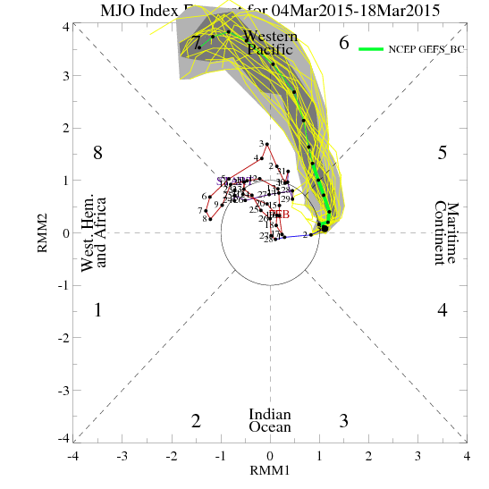
The MJO forecast makes the long-range forecast interesting as well and supports a possible AR event in the long-range. It is not too often that you see the forecast go off the charts... So we will have to see how the MJO activity in the Western Pacific may affect the pattern if the forecast holds.
Stay tuned....BA
About Our Forecaster
Bryan Allegretto
Forecaster
Bryan Allegretto has been writing insightful posts about snow storms for over the last 15 years and is known as Tahoe's go-to snow forecaster. BA grew up in south Jersey, surfing, snowboarding, and chasing down the storms creating the epic conditions for both.
Free OpenSnow App


