Tahoe Daily Snow

By Bryan Allegretto, Forecaster Posted 8 years ago July 15, 2015
The Hype Continues...
Usually during the Summer months I try to decompress from the busy winter season. I will normally begin looking at putting together a seasonal forecast by fall. But this Summer I can't look at the news or Facebook without seeing an article hyping the El Nino. I want a big season as much as anyone, but I am not convinced yet on this season. We are not a media site driving traffic by hyping stories. We are a forecasting site that drives traffic by trying to be the most accurate.
Back in the Fall of 2010 we came out with a seasonal forecast for 125% of average snowfall for Tahoe. We got laughed at and accused of hyping, but after a 150% of average season we gained attention for being accurate(or lucky...). I'm fearful we could see the opposite this Winter where we are one of the few forecasting below average snowfall and get laughed at, and then end up being accurate. Not that we are using different tools than the rest of the forecasters, but I feel like with most of the articles coming out this summer the focus is only on the El Nino forecast and nothing else.
We have been putting together a Winter Season forecast monthly this Summera at Opensnow, but for internal purposes only and we won't release one yet. The screaming message to me seems to be that the analog forecast based on the SST's (Sea Surface Temps) for the entire globe gives us a completely opposite forecast for snowfall than if we just analog based on the forecasted strength of the El Nino.
Just looking at El Nino events by strength since 1970 it is true that the stronger the event the more precip and snowfall CA receives on average. The current conditions for El Nino would put it in a strong category already, with the 3 month running average at moderate. But not all strong El Ninos are the same and we can't ignore everything else going on.
Taking the 97-98 El Nino event for example which was a very strong event, the SOI (Southern Oscillation Index) which is a good indicator of the conditions needed for a strengthening Nino was running around -20 during June that year, and only -10 this June. That may be because the water around Australia is so warm and is normally colder for larger Tahiti-Darwin pressure difference that would favor a strengthening El Nino. The warm SST's along the equator this Summer are also shallower in comparison to that event. The MJO convection moving through the Pacific, tropical activity, and strong westerly wind bursts causing Kelvin waves have all helped to push this current event into strong territory. But with the differences with the conditions vs other strong events I'm not 100% convinced yet that this event will be as strong as the models show it getting by December, or that it doesn't start to weaken when the Westerly wind bursts relax.
Below are the SST anomaly during the Summer of 1997. You can see the colder water around Australia.
.png)
You can also see the colder water in the North Pacific vs the current SST anomaly below, especially off the Pacific NW coast.
.png)
So let's pretend that the strong El Nino conditions persist through the Winter. Ok, does that mean 100% chance of big rains and snows? Going back to 1950 only 4 of the 6 strong El Nino events brought above average snowfall to Tahoe. The other 2 brought well below average snowfall including only 58% of average for the 87-88 event. So I broke each of the 6 down by when the strong conditions came on, peaked, and faded. Then compared that to the forecast for this upcoming season. The closest match from my perspective was 1972-73 which brought 107% of average snowfall.
Here is a graph I put together of the snowfall vs average on Donner Summit at the Central Sierra Snow Lab broken into each season and each strength of El Nino. Fall=Oct-Dec, Winter=Jan-Mar, and Spring=Apr-Jun. That is off by a month from meteorological seasons, but it made more sense for ski resort opening and closings. It shows strong El Ninos bring above average snowfall during each season on average.
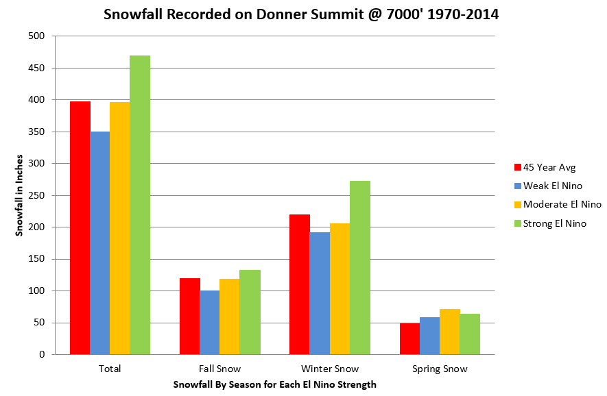
(numbers courtesy of Central Sierra Snow Lab)
If this El Nino does end up in super strong territory and that persists through the Winter that could mean another 97-98 or 82-83 like all of the media articles keep saying. Those 2 winters averaged 147% of average snowfall and we are looking at another 10-11 season.
But as I mentioned above and the last 2 posts the Northern Pacific SST's were different those years and the extremely warm blob of water was not sitting off the Pacific NW coast. El Nino conditions displace the subtropical jet further North but can it overcome a ridge sitting along the West Coast centered over the Pacific NW like the last 2 seasons? Which may be blamed on the warm blob that is still there.
We can't just run analogs to El Nino strength and say there is a 75% chance of 114% of average snowfall during Strong El Ninos. When we look at the forecasted SST's for the entire ocean for the upcoming season and analog against that we can come up with something completely different. Like a ridge over the West Coast and below average precip.
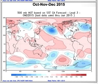
(image from weatherbell.com)
You can see how the precip is below avg. over CA and above avg. from Texas to the Northeast. The jet stream isn't displaced far enough North.
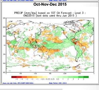
(image from weatherbell.com)
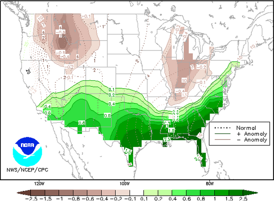
NOAA's seasonal forecast for precipitation departures from average for Dec-Feb doesn't look much different currently.
Probability of Exceedence (POE) Maps
for Dec-Jan-Feb 2015-16
We have been running snowfall forecasts based on analogs for the SST's in the entire Pacific and back to 1979. Including the ENSO region but not only based on the strength of El Nino. Doing that some of the snowfall forecast maps are coming up with forecasts for below average snowfall this season... They show that the jet stream is only displaced far enough North to bring average snowfall to Southern CA and then above average from the Southwest to the Northeast. The ridge sits over the Pacific NW and the cold trough anchors over the East like last Winter. Yikes!
I could show you forecast models that show well above average precip for CA this Winter like I did in previous posts, but that is not the point in this today's post. I thought I would counter all the media hype today and show some of the reasons why we should give pause because there is a chance we could see another dry Winter. I am hoping for a big Winter. I can see how if the super strong El Nino shown by somes models comes to fruition we could see a wet and snowy winter for CA. But I can't deny some of the things discussed above that could mitigate the strength and affect of the El Nino on our weather and snowfall this season.
Off the record for the few of you who read a snow forecast blog in the Summer... I have been telling my friends over the past year that my gut tells me to be excited for a strong La Nina that we could flip to for the 16-17 season, along with the water off the coast cooling by then. But I would take back to back big winters after the last 4 seasons....
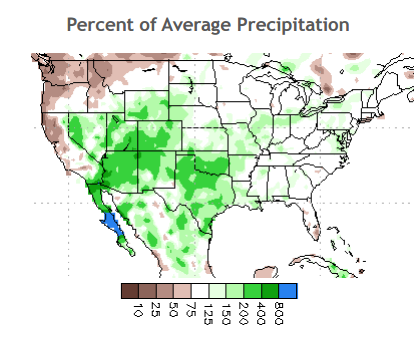
Meanwhile the spring and now into the summer we have seen above average precip. After a brief dry spell the last few days we may see more moisture moving into the area. There were some impressive downpours last week, especially over Reno. Reno is already at 233% of average precip for the month of July, and 200% of average for the last 3 months. That brings the city to 94% for the calendar year.
The last 3 months have been above average in Western NV and for the Eastern Sierra...
(from NOAA El Nino Discussion)
Hopefully this keeps going into the Fall and Winter. Whether we get big snows or not I will be winterizing the lodges on Donner Summit in September and readying the snow cat and measuring sticks. Just in case the snows come early which they tend to do during El Nino events.
I will be updating more on El Nino and seasonal forecasts as we go through the Summer and Fall.
Stay tuned....BA
About Our Forecaster
Bryan Allegretto
Forecaster
Bryan Allegretto has been writing insightful posts about snow storms for over the last 15 years and is known as Tahoe's go-to snow forecaster. BA grew up in south Jersey, surfing, snowboarding, and chasing down the storms creating the epic conditions for both.
Free OpenSnow App


