Tahoe Daily Snow

By Bryan Allegretto, Forecaster Posted 8 years ago October 6, 2015
Watching and Waiting....
Sounds like the title of the last 4 Winter seasons....
We saw some decent rains last week and this past weekend around the area. The snow levels stayed fairly high above 9000 ft. September ended up a dry month after some wetter months earlier in the Summer, and then we started October wet. The temperatures were near normal averaging 0.6 degrees above average.
Short Term:
High pressure is building in and we are heading into a warming trend through the end of the week.
The next chance for any precip looks to be a tropical system possibly moving North into Southern CA later next week that could push precip this far North by the weekend of the 16th.
Longer Range:
The storm activity will pick up over the Pacific NW the next 2 weeks but will stay to our North which is typical in the Fall. The super long-range of the models has hinted at a trough possibly digging further South around the 22nd, but that is really far out.
So for now we will continue to sit and wait for the first real snow of the season. I'm almost ready up here at the lodges on Donner Summit. We stacked 12 cords of wood this past weekend, the snow cat is just about ready, and the yard is winterized. Just need to put the snow breaks over the 1st floor windows. Also, I'm planning to install a live cam here at the office pointing towards my measuring area that we can stream live to the website for you.
El Nino:
We saw some strong Westerly wind bursts the past week which pushed some more warm water into the ENSO regions. We saw warming in most zones over the past week, with some getting close to 3 degrees above average.
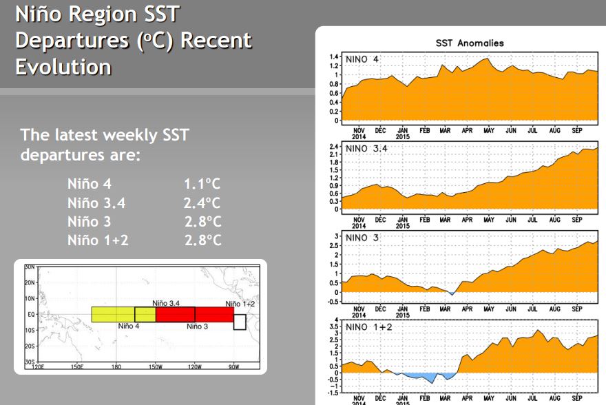
It had looked like the warmest water was shifting West towards a East-Central centered El Nino back in August, but now it is back East into a classic Eastern El Nino. We may see some additional warming the next several weeks before we peak, but we will have to see how that affects the ONI. That is the 3 month average for region 3.4 that is used as the criteria for official El Nino events, and official strength.
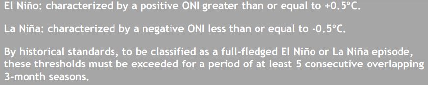
We have had 6 consecutive overlapping 3-month seasons so it is a full fledged El Nino, and it is a strong event as of the end of September at 1.5 degrees above average.
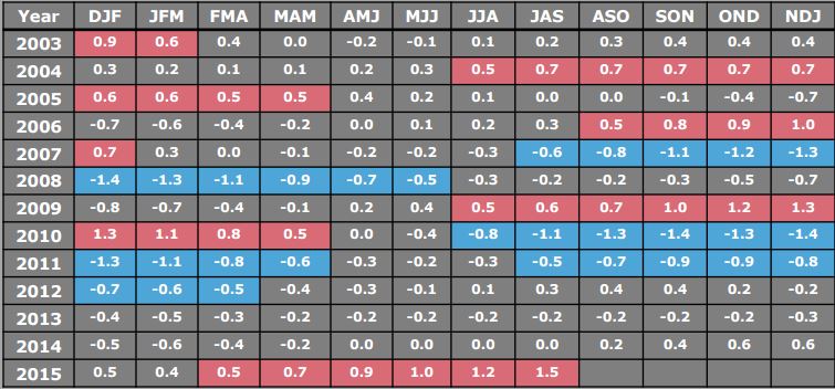
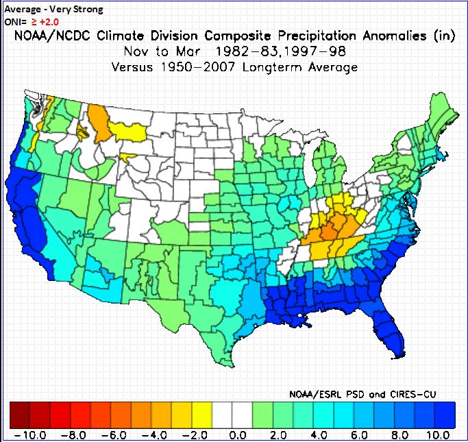
You can also see the last El Nino in 09-10 that was a moderate El Nino peaking at 1.3. This one is expected to peak above 2 degrees with the average of the forecast models currently forecasting it to peak in December near 2.5 degrees. Above 2 degrees puts it into the super strong category with only 82/83 and 97/98 in that category the last 50 years. So where do we sit currently compared to that?
![]()
![]()
We are a half a degree ahead of 82 and .2 degrees behind 97. Both years peaked in December at 2.1 & 2.3, pretty close to where we may peak this year. Only looking at 2 events we don't have a statistically significant amount of examples to come to a conclusion that a wet Winter is guaranteed. But both Winters were very wet for all of CA.
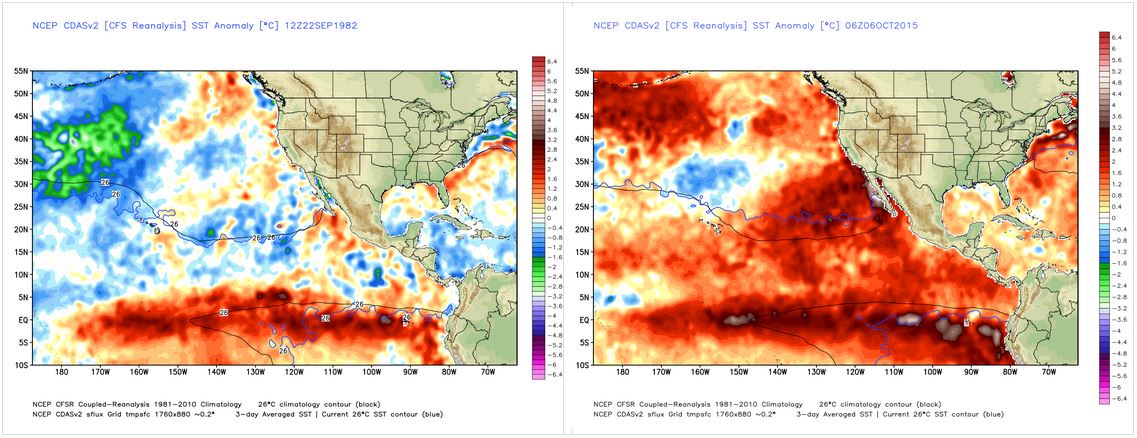
We didn't see a positive a lot of warmth in the Eastern Pacific the last 2 events which some have blamed the persistent high pressure over the Eastern Pacific on. The Eastern Pacific continues to cool week after week so even if that was the cause the water is cooling. Still, it's very warm in the Eastern Pacific compared to the last 2 events, so how will that affect the pattern if at all compared to those 2 seasons?
Sept. 1982 is on the left and Current is on the right.
Sept. 1997 on the left, Current on the right.
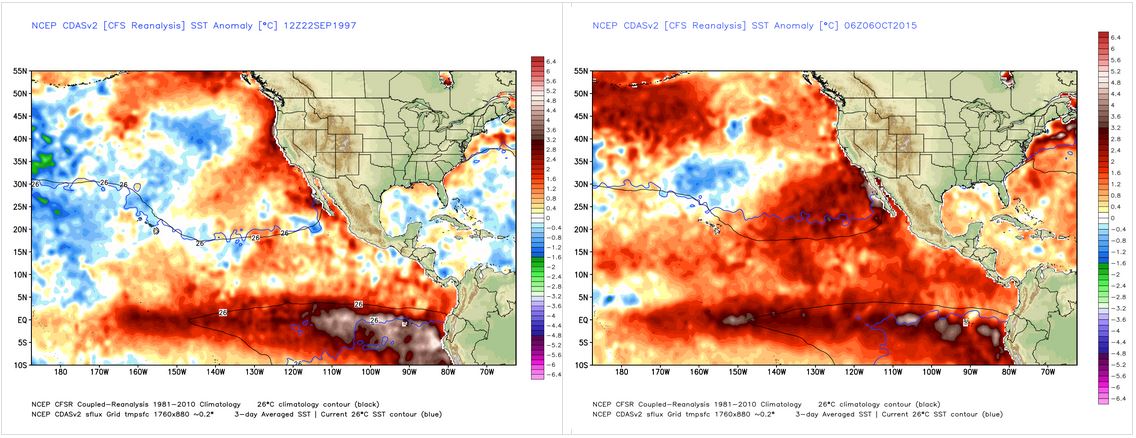
The current SST's and the forecasted Sea Surface Temps have changed our snowfall models over the past few months. Now they show slightly above average snowfall in the Sierra. The climate models are coming into better agreement as well with the trough in the Eastern Pacific hugging the West Coast.
.gif)
With precip forecasts that look like this for CA.
.gif)
Pretty similar to the precip that actualized in 82/83 & 97/98. So as things evolve and we get closer and closer to Winter the chances that we could see above average precip even into Northern CA seem to increase. I'm feeling better about that forecast each week, but what about the snow?
82/83 was colder and we saw more snow than rain and lower snow levels. 97/98 was warmer and we saw rain and snow but enough snow to still come out above average for snowfall. There was also less total precip in 97/98.
You can see that 97/98 was not much higher than 09/10. That season we had above average snowfall above 7000 feet but below average at lake level due to high snow level storms. That is my fear for this upcoming season, and why I am not jumping onto the giant snow year band wagon, even if one foot is in the above average precip wagon.
Another interesting fact for 97/98 that I pulled from Golden Gate weather is that although CA saw double the average amount of precip, the amount of flooding and damage was not nearly as much as in other non-El Nino years. So the doom and gloom hype may also be just that. We could see a lot of precip without extreme flooding events if it spreads out over the season.

Currently the forecasts show the heaviest precip occurring in the heart of Winter from Jan-Mar. That could make this the first season with snow in January in 5 years. Even the 10-11 season we had below average snowfall in January.
No matter what happens this season should not be as boring to forecast as the last 4...
Stay tuned....BA
About Our Forecaster
Bryan Allegretto
Forecaster
Bryan Allegretto has been writing insightful posts about snow storms for over the last 15 years and is known as Tahoe's go-to snow forecaster. BA grew up in south Jersey, surfing, snowboarding, and chasing down the storms creating the epic conditions for both.
Free OpenSnow App


