Tahoe Daily Snow

By Bryan Allegretto, Forecaster Posted 8 years ago November 4, 2015
More Storms on the Way...
Update Thu AM:
No changes to the forecast from yesterday. Everything still looks the same for the storm Sunday night into Monday. Two systems may brush us to the North next Thu-Sat, we'll keep watching those to see how far South they come. Forecast models are now split on the pattern for the week of the 16th with some of them trying to put the ridge back in place off the West Coast, while the others still show a big storm.
Summary:
Cold air is in place through Wednesday with highs only in the 30's at lake level, and 20's on the mountains. High pressure builds in going into the weekend with highs rebounding into the 40's. Then Sunday night into Monday the next cold storm drops down the West Coast. This storm will have snow levels starting at lake level and could bring several more inches of snow to the Tahoe basin.
The pattern looks to continue to be active. We could see another system Friday the 13th, and some bigger storms the week of the 16th.
Details:
We saw some light snow showers last night mainly East over Reno. Lake effect snow bands setup South of Pyramid lake just to the East of Reno, and another band setup off of Tahoe near Tahoma overnight. There is plenty of cold air in the wake of the last two systems that will stay in place. It will warm slightly going into the weekend.
We have been keeping an eye on the next storm dropping down the West Coast. The trend with these storms the last couple of weeks seems to be further South and West down the coast as we get closer, which is great news for us. This storm continues to trend a bit West with the low picking up some moisture off the Pacific before moving inland over Northern CA on Sunday.
We will work on the timing as we get a little closer but it looks like the snow will begin to fall Sunday night lasting into Monday before the low pulls away. This storm won't have an Atmospheric River cutting in underneath of it, so we are expecting modest amounts of precip. But it is a cold storm and snow levels will start below lake level, so we should see some higher snow ratios to help boost totals.
Here is the latest 6z GFS total precip forecast.
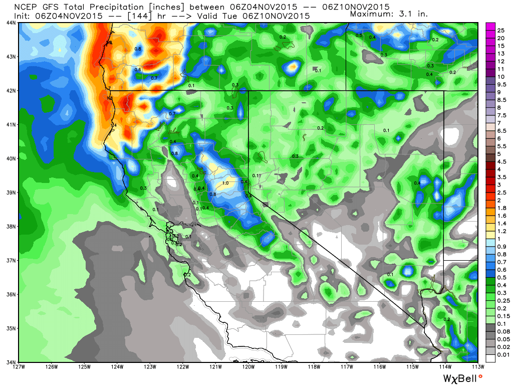
This storm should shadow East of the crest and East of the Sierra front so snow totals will be highest West of the lake along the crest. Looking at the GFS and Canadian runs we could see 2-5 inches on the East side of the basin and 5-8 on the West side at lake level. We could see slightly higher totals on the mountains with higher snow ratios. Initial guestimates of 3-6 inches above 7000 feet, and 4-8 above 8000 feet East side. 6-9 inches above 7000 feet, and 8-12 inches above 8000 feet West side of the basin. Maybe up to 15 inches on a mountain West of the crest.
The interesting thing this morning is that the 0z European model last night had about twice as much total precip forecast as the other models. So we will keep watching the trends as we get closer.
Long-Range:
We are in a great pattern right now with the ridge staying North of Hawaii keeping the storm door open. Another cold storm will drop down the West Coast next Friday the 13th. This storm is also trending further South after looking like it would miss us to the North, so we will keep watching it.
Even more interesting is the ensemble runs of the forecast models all in decent agreement that the pattern holds into the week of the 16th when some stronger storms could drop into the West Coast. This pattern is consistent with a negative PNA pattern which we have flipped to for now.
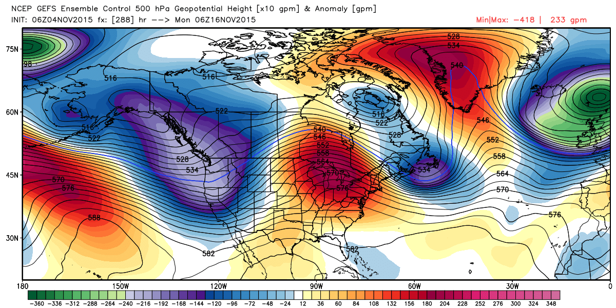
Here is a look at the strong trough being forecast by the GFS the week of the 16th.
So for now we are in a good early season snow pattern. Tahoe kicks off the season today with Mt Rose opening, and Boreal on Friday. Many other ski resorts have announced opening days this week. If this pattern holds for a couple of weeks it could be the best Thanksgiving conditions since 2010.
Stay tuned....BA
About Our Forecaster
Bryan Allegretto
Forecaster
Bryan Allegretto has been writing insightful posts about snow storms for over the last 15 years and is known as Tahoe's go-to snow forecaster. BA grew up in south Jersey, surfing, snowboarding, and chasing down the storms creating the epic conditions for both.
Free OpenSnow App


