Tahoe Daily Snow

By Bryan Allegretto, Forecaster Posted 8 years ago November 25, 2015
Dashing through the Snow...
Summary:
Snow showers will continue today with a light fluffy snow falling. The winds could still be a little gusty on the mountain tops with blowing snow. Expecting 1-3 more inches of snow today around the lake with slightly more possible on the mountains. Scattered snow showers possible through Saturday as the storm is stalled over the region. The weather stays cold as well with highs only in the 20's and lows in the teens.
We should see a break Sunday before another storm pushes in Monday and maybe another for next Thursday. The active weather pattern looks like it could stay for now.
Details:
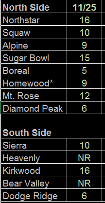
The storm delivered pretty close to the forecast yesterday. If anything we saw some higher than forecast snowfall amounts in some places. We did see better spillover of precip into the Tahoe Basin so we have reports of up to 10 inches of snow at some lake level locations. The forecast was for 3-6 inches on the East side of the lake and 5-8 on the West side, so I think we came in pretty close from the reports I'm getting.
For the ski resorts the forecast was for 5-8 inches on the East side of the lake and 8-11 on the West side, with up to 14 inches on the highest peaks West of the lake along the crest. Below are the snowfall reports as of 7 a.m., still waiting for some resorts to update the numbers from last evening and other to report at all... You can also track the reports for the last 30 days on our resort pages.
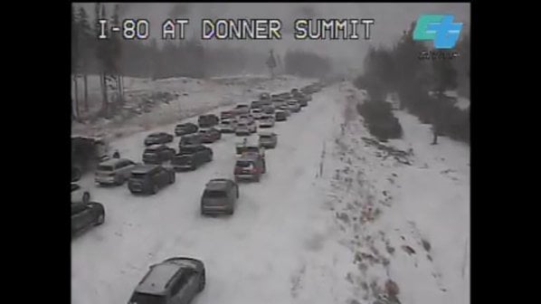
This storm wasn't big by Tahoe standards, but the headlines were the cold and the timing with the busiest travel days of the year yesterday and today. The roads were a mess yesterday with accidents. I got to work just before the snow started falling and stayed until late last night to drive home so I could avoid the mess. Didn't work... a snow band setup along I-80 from 7:30-8:30 that followed me home... We had a wedding at the lodge yesterday and it was beautiful with all the snow, but 20 guests didn't make it from the storm. It was definitely cold though standing outside directing cars. The snow coming out of the snow blowers looked like steam it was so light.
The low is stalled and spinning over Nevada today just to our East. A wave of moisture is wrapping in from the North which will kick off an increase in snow showers today. The forecast models have bumped up precip amounts for today slightly and I have bumped up the snowfall forecasts a bit as well. We could see 1-3 inches of new snow today with some mountains picking up 2-4 inches. It is impossible to forecast where the heavier snow bands will setup.
We did see a lake-effect snow band setup overnight coming off of Lake Tahoe over Spooner Summit right where we thought it might setup.
Bands like that create several more inches of snow outside of the forecast...
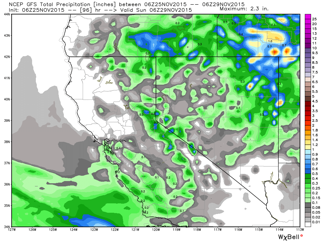
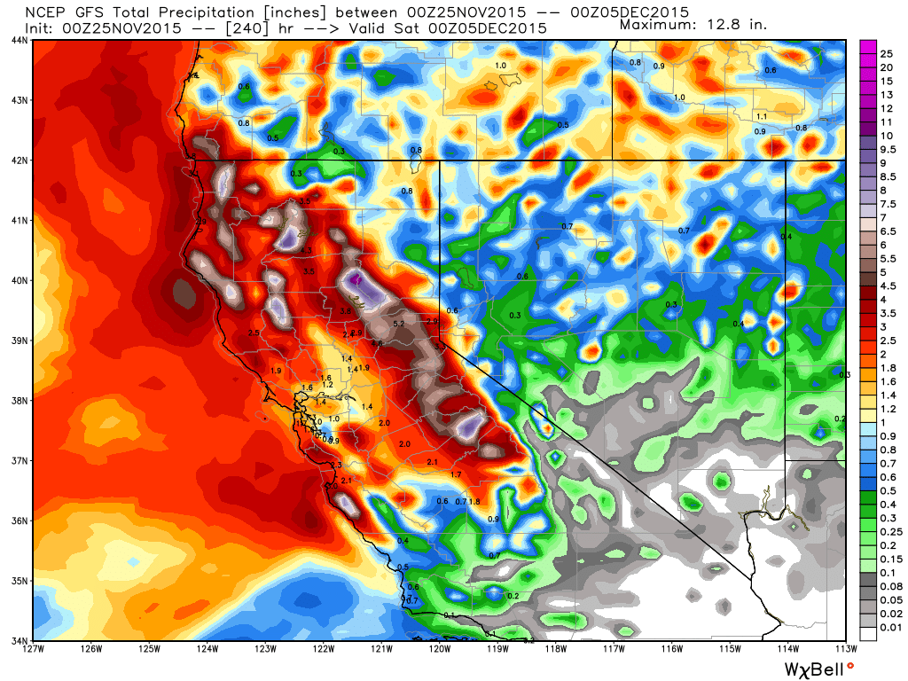
The low will spin over the region through Saturday. As it backs up a little towards CA Friday into Saturday we could see increased snow showers. That could bring 1-3 more inches over the 2 days with 2-4 inches for the mountains. We will have to see how much moisture is still around. Looking at the latest GFS total precip forecast it shows the heaviest precip over the next 4 days falling mostly over the mountains with the increased lift. You can see the higher amounts NW of the lake near Sugar Bowl, NE of the lake over Mt. Rose, and Southwest of the lake near Sierra and Kirkwood.
The temperatures stay cold through Saturday with highs in the 20's and lows in the teens. The cloud cover will keep temps from bottoming out, but if we see clearing at night I would expect the lowest valleys to hit single digits.
We run into much disagreement on the forecast models starting next week. The ridge will be over Canada so the storm door will be open underneath into CA. A large trough will push into the Eastern Pacific and the GFS and Canadian models push the first storm into CA by Monday. The European mdoel however keeps the forecast dry with the storm staying off the coast. For now will go with the 2/3rds majority and will be looking for more snow to move in Monday. The GFS has backed off on precip amounts this morning but on previous runs it was pretty wet like the Canadian. So we will keep tracking this one down.
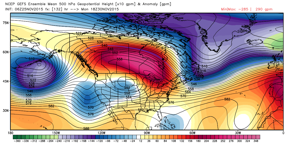
Here is the GFS height forecast showing the next area of low pressure moving towards CA Monday while the current one is departing to the East.
Long-Range:
The forecast models are in better agreement that the next storm could move in next Thursday. So we may finally get a week with 2 storms. These storms won't be as cold as the ones we have seen so far this season, but they could be wetter with higher snowfall totals for the mountains. It's too early to tell snow levels as we don't know the exact track of the storms.
Here was the GFS 10 day total precip forecast from the 0z run
and the latest 6z run
.png)
Either way the pattern looks to remain active for now. The ensemble runs show that we could see a break the weekend of the 5th as the Eastern Pacific trough retrogrades, and then increased storminess again the following week as it pushes towards the West Coast again. The long-range during the change of the seasons is always difficult for the forecast models. But it looks like we are getting closer to an El Nino influenced pattern in December. Not expecting as much sleep this year...
Well, I am off to the in-laws house up North today for Thanksgiving. Safe travels everyone. I am not going this route, taking the back roads...
Stay tuned....BA
About Our Forecaster
Bryan Allegretto
Forecaster
Bryan Allegretto has been writing insightful posts about snow storms for over the last 15 years and is known as Tahoe's go-to snow forecaster. BA grew up in south Jersey, surfing, snowboarding, and chasing down the storms creating the epic conditions for both.
Free OpenSnow App


