Tahoe Daily Snow

By Bryan Allegretto, Forecaster Posted 8 years ago November 28, 2015
The Week Ahead...
Summary:
One more day of really cold air Saturday. Sunday we rebound back into the 30's and then 40's by Wednesday which is average for this time of year. A splitting system will bring just clouds on Monday. Another splitting system Wednesday will bring more clouds and maybe very light snow on the mountains.
Thursday a stronger system will push in with the possibility for heavier snowfall and a cold front bringing in some colder air. We could see a few inches down to lake level and up to a foot on the mountains. We will keep watching the trend on possible totals.
After a break next weekend we could see some more storms the following week.
Details:
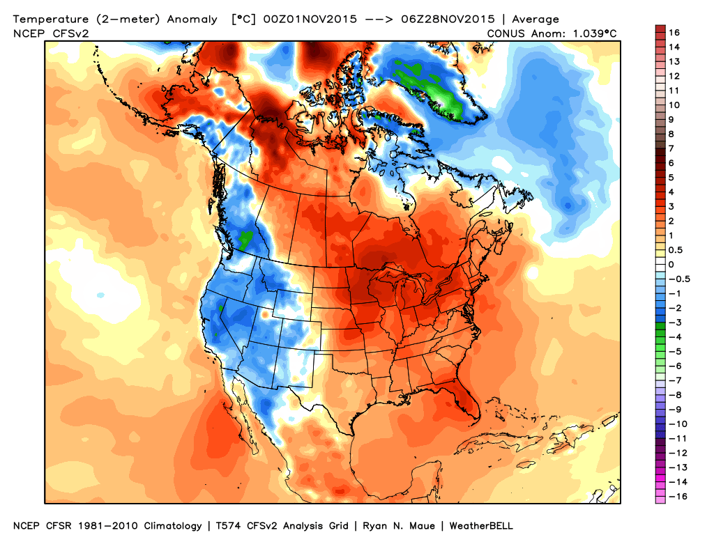
With clear skies and light winds we dipped below zero this morning in Truckee. Not sure the official number but it was 6 below when I got up. We are running 18 degrees below average over the last 3 days and a few degrees below average for the month. Here is a look at the U.S. temperatuere departures for November. Kind of the opposite of what we should see going into the El Nino pattern.
We didn't much in the way of snow showers yesterday as the system now has a lack of moisture. Not expecting much in the way of showers today either.
Here's a snapshot of where we sit with the ski resort snowfall so far. Pacing a little ahead for the season, but this is compared to % of season completed, not the average snowfall by month.
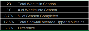
Looking at Donner Summit at the office we would average 49 inches by the end of November. So far we have picked up 30 inches, so we are only at 61% of average for this time of year. We have had 4 cold storms in November 4 weeks in a row, but no significant storms yet. We average 71 inches for December so we will have to pick up at least 90 inches to catch back up to average.
The storm for Monday moves into Western Canada with the trailing front now looking like it will split apart enough for only clouds for us Monday. Taking score the European model had the forecast right a week out.
Another front moving through Wednesday may hold together enough for very light snowfall ahead of the stronger front on Thursday. The European this time is most agressive Wednesday with a few inches of snow along the crest.
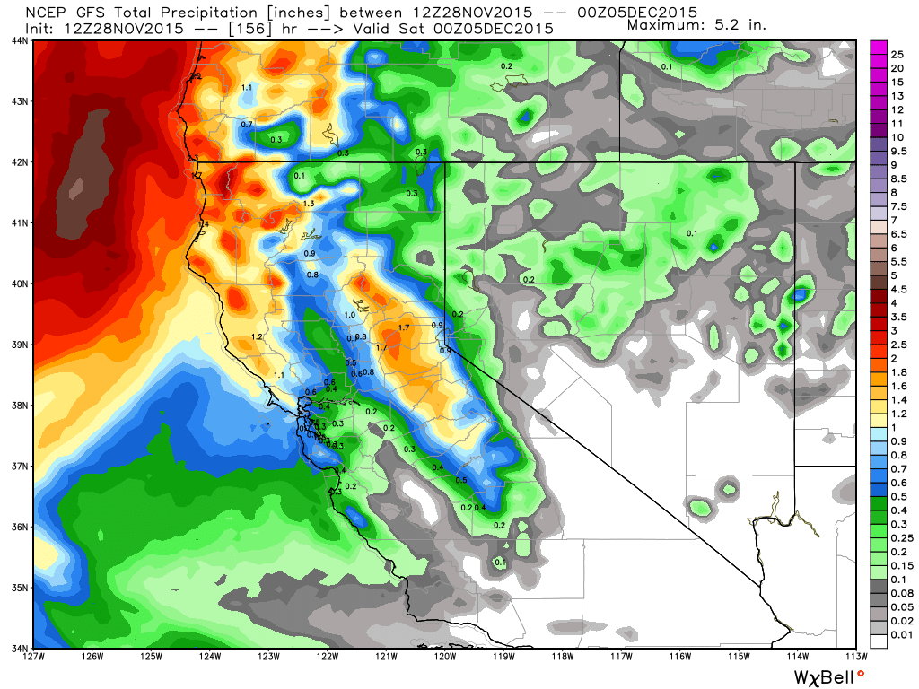
A cold trough pushes into the West Coast on Thursday. The forecast models have it taking on a negative tilt which brings the winds from the South. That would keep the snow stuck along the crest until the front pushes through. Looking at the current precip forecasts we still could pick up a few inches down to lake level, and several inches up to a foot on the mountains. Highest amounts definitely on the West side of the lake up along the Sierra Crest. We will keep fine tuning this forecast the next few days.
Here is the latest GFS forecast for total precip.
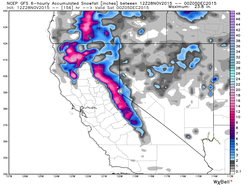
and total snowfall...
It looks like the ridge will briefly build over the West briefly behind this storm next weekend with a break and warming temps.
Long-Range:
The current long-range forecast model runs show the possibility of a similar pattern week 2 with a splitting system to start the week on Monday the 7th, and then the possibility of a stronger storm by Wed-Thu.
Low pressure looks like it will spend most of its time in the Gulf of Alaska the next couple of weeks, and high pressure over Canada and the Eastern U.S. That should keep the pattern active along the West Coast of Canada and the U.S. Still looking for the first big storm of the season. Right now the jet stream is still focused to our North, but it should push further South as we go through December.
Stay tuned....BA
About Our Forecaster
Bryan Allegretto
Forecaster
Bryan Allegretto has been writing insightful posts about snow storms for over the last 15 years and is known as Tahoe's go-to snow forecaster. BA grew up in south Jersey, surfing, snowboarding, and chasing down the storms creating the epic conditions for both.
Free OpenSnow App


