Upper Midwest Daily Snow

By Andrew Murray, Technical Founder & Meteorologist Posted 8 years ago September 22, 2015
El Niño in the Upper Midwest
It’s everywhere you look now: we are headed for an El Niño here in the United States. We’ve heard of the torrential rains headed for California, and the bitter cold on the East Coast. However, what does El Niño mean for winter here in the Upper Midwest?
For us winter lovers, there is some good news and some bad news.
First, lets talk about temperatures. When it comes to El Niño winters, there is definitely a correlation between a strong El Niño and above average temperatures over the course of the winter. You can already feel it now in our warm autumn days here in late September. The seasonal forecasts are very much aligning with this trend, with all the monthly outlooks putting the Upper Midwest with at least a 50% chance of an above average winter.
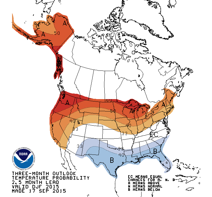
So what does an above average temperature mean? During a strong El Niño year, we average between 4-8º above normal for the winter. No, that doesn’t mean we won’t see any below zero days (or weeks). Nonetheless, 4º above normal means more days in the 30s than the 10s. So look forward to a winter similar to last years in terms or temperatures, with maybe a few more warmer days thrown in.
Now for the important stuff — the precipitation forecasts for this winter.
Last year was a dry winter for southern and central Minnesota and Wisconsin, and barely hit average in the north and UP. When it comes to the average strong El Nino, it’s all over the place. Both the driest and 2nd wettest winters have occurred during a strong El Niño. So there is very little correlation between it simply being an El Niño year and what kind of snow we should see. Mostly because with any place that has a snow dominated winter, the difference between a good and bad winter can be as little as two winter storms. The very strong El Niño in 1982-83 had multiple 1-2 foot storms across the region, leading it to the 2nd wettest ever on record.
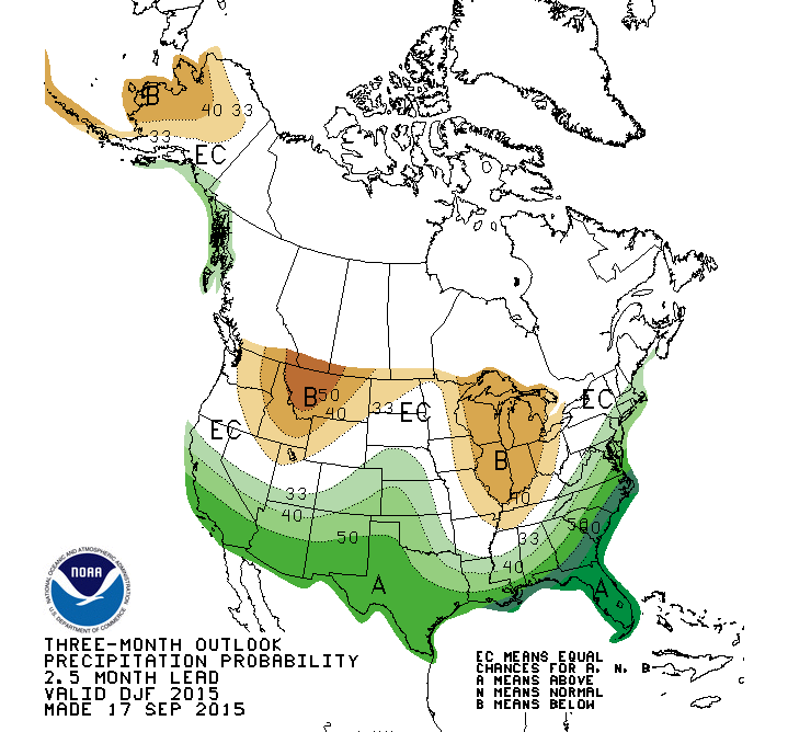
Looking at the monthly climate models draws a more grim picture for us. Over the past couple of model runs, they have trended closer to having a below average amount of precipitation for the heart of the winter months. While it’s still in the 30-40% chance range, I’m not feeling too confident since the models have pushed this number slightly higher month to month. However, with how wet this autumn has started off, we can hope that we at least stick to around normal this year.
Regardless, this is all seasonal forecasting and doesn’t show a storm by storm picture for the region by any means. So fingers and toes crossed that we ended up with a mild winter with piles of snow.
Look for another update in October!
Andrew
About Our Forecaster
Andrew Murray
Technical Founder & Meteorologist
Andrew manages the technology that powers OpenSnow, and he also keeps an eye on the weather for the Upper Midwest from his home base in Minneapolis since 2015.
Free OpenSnow App


