News

By Sam Collentine, Meteorologist Posted 10 years ago February 17, 2014
Weather for the week - Feb 17 to Feb 21, 2014
For this week, the Northwest will continue to dominate the powder reports while an eerily similar weather pattern begins to unfold across Utah and Colorado. The Northwest will see endless snorkle deep powder this week as abundant Pacific moisture continues to stream into the region. The rest of the country will not miss out on all the goods though as every region will see fresh snow sometime during the next 5 days.
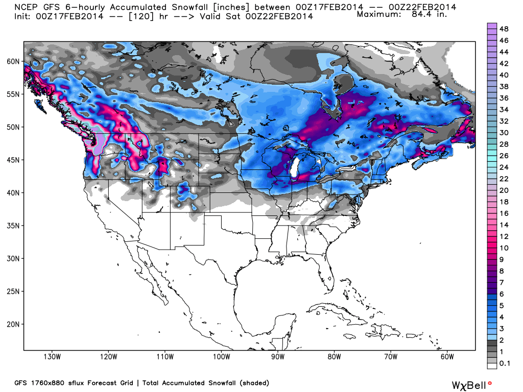
Total accumulated snowfall, according to the American GFS, through Friday night. Source: WeatherBell.com
Northwest
The bullseye this week is centered over the Northwest as storm after storm continues to move across the region. The jet stream, along with abundant Pacific moisture, will stay anchored over the region providing feet of powder throughout the week. What's even better this week is that the snow levels will continue to drop as the systems trend colder. This will lower the moisture content of the snow providing even better conditions. Everyone from Whistler to Mount Hood to Mount Bachelor will share the excellent powder conditions. This week is about as close as you can get to a guaranteed powder forecast so you will not be let down if you call in sick for work. Larry will have all the details in The Northwest Daily Snow.
Colorado and Utah
Colorado and Utah will start the week with mild temperatures and dry conditions before the next storm cycle moves in on Wednesday. This system will be much more typical for Colorado and Utah as it will not have the deep stream of Pacific moisture as we have seen over the previous few weeks. The system will be colder and the threat of rain will be non-existent. Our Utah Forecaster is calling for 6-12 inches on Wednesday night leading to a good powder day on Thursday. Colorado will also have the potential to see 6+ inches on Wednesday night. It will be another in-between day on Thursday before a persistent northwest flow allows for chances for snow Thursday night and into the weekend. Joel and Evan will break it all down in the Colorado and Utah Daily Snow.
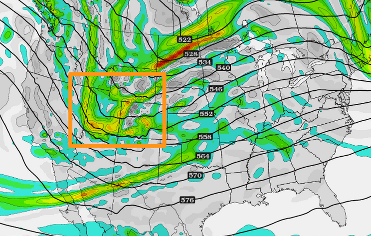
Wednesday night's storm, as shown on the GFS 500mb vorticity model, will bring the next significant snowfall to Utah and Colorado. Source: TwisterData.com, analysis by OpenSnow.
Lake Tahoe
The Lake Tahoe region will see it's next chance for snow on Wednesday but accumulations will not amount to much. Lake Tahoe will be too far south and west of the main storm track to bring any significant snowfall to the region this week. Temperatures will be cooler with Wednesday's system but will become more mild on Thursday and Friday. Head over to The Tahoe Daily Snow for all the details.
Upper Midwest
Fresh snowfall and warmer temperatures headline the Upper Midwest this week. Wisconsin, Minnesota, and Michigan will see anywhere from 2-6 inches on Monday as a quick moving system makes it's way across the region. This will then clear out on Monday night allowing for temperatures to reach the mid to upper 30's on Tuesday. With fresh snow and above average temperatures, Tuesday looks to be a great day of skiing so call out of the office if possible! Big changes then begin to take place Wednesday as another potentially strong system moves into the region. More snow and colder temperatures will accompany this system throughout the rest of the week. Andrew will have the latest details in The Upper Midwest Daily Snow.
New England and Mid-Atlantic
The Northeast's epic season continues this week as another system moves into the region on Tuesday. This will be very similar to this past weekend's storm as it will quickly move across the Mid-Atlantic and then track up the coast into New England. Totals will be best across central Pennsylvania and northern Maryland for the Mid-Atlantic and central Massachusetts and southern and central New Hampshire for New England. A big warm-up will occur during the second half of the week so get out and enjoy the fresh snow and cooler temperatures while you can! Justin and Brian will break it all down in the Mid-Atlantic and New England Daily Snow.
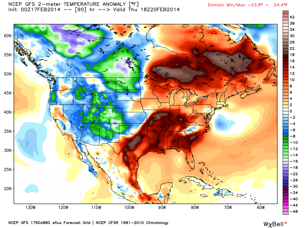
Temperature anomaly, or the departure from the long-term average, as of Thursday. Source: WeatherBell.com
When you're up on the hill this week post pictures and updates using "LiveSnow", one of the features of our FREE iPhone and Android app.
Always check our Powder Finder and the forecasts for each mountain throughout the week for more details.
Sam Collentine | OpenSnow
PS - Want a ruler sticker? Go to your settings page and update your mail address so we can send you one.
About The Author
Sam Collentine
Meteorologist
Sam Collentine is the Chief Operating Officer of OpenSnow and lives in Basalt, Colorado. Before joining OpenSnow, he studied Atmospheric Science at the University of Colorado, spent time at Channel 7 News in Denver, and at the National Weather Service in Boulder.
Free OpenSnow App


