News

By Sam Collentine, Meteorologist Posted 10 years ago January 27, 2014
Weather for the week - Jan 27 to Jan 31, 2014
For this week, snow returns to the West while bone-chilling temperatures remain across the Upper Midwest and Northeast. The high-pressure ridge that left the West under mild and dry conditions throughout the middle of January will finally breakdown on Tuesday allowing for storms to move across the region. The Upper Midwest and Northeast will remain under frigid temperatures throughout the middle of the week as Arctic systems continue to track across the eastern United States.
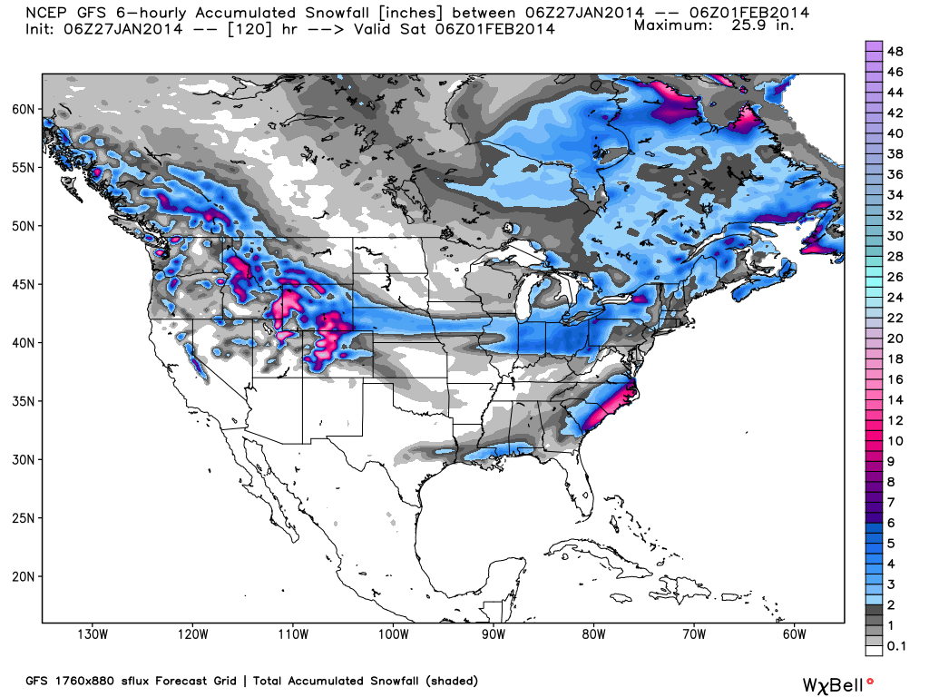
Total accumulated snowfall, according to the American GFS, through Friday night. Source: WeatherBell.com
New England will see another system move through on Monday with light to moderate accumulations expected. The higher elevated resorts in the north will likely come away with the highest totals as the storm track pushes northeast across southern Canada. Jay Peak, Stowe, and Smuggler's Notch in northern Vermont look to have a good powder day on Tuesday as locally heavier amounts can be expected for these areas. Another blast of Arctic air will sweep across the Northeast during the middle of the week before the next system moves through on Friday. Brian Clark will have the latest details in The New England Daily Snow.
The Mid-Atlantic region will be to far south this week to see any snow accumulations. Temperatures will remain well below average for most of the week allowing for around-the-clock snowmaking. Another weak system looks to move through the region at the end of the week so stay tuned. Click over to The Mid-Atlantic Daily Snow for the latest details.
As for the Upper Midwest, this week will again consist of brutally cold and dangerous temperatures. Temperatures will not get out of the negatives until Wednesday ahead of the next system that will move through the region on Thursday. Wind Chill Warnings are in place Monday through Wednesday so take the necessary precautions when headed outdoors. Andrew Murray will have all the details on this blast of Arctic air in The Upper Midwest Daily Snow.
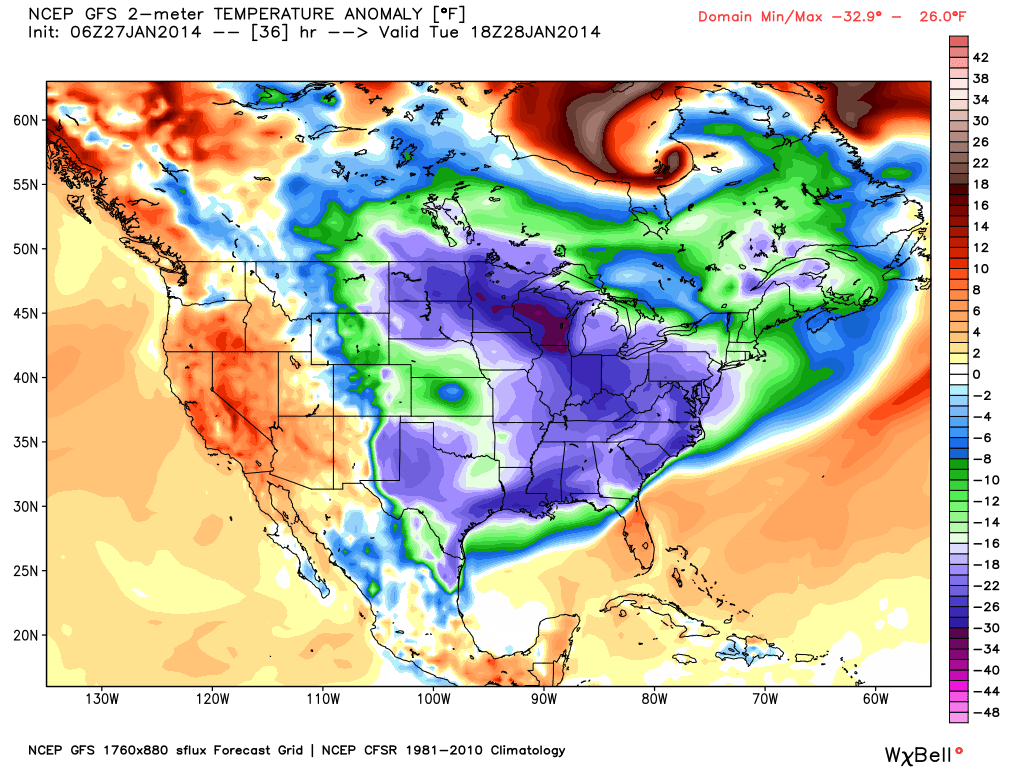
Temperature anomalies, or departure from the long-term average, in degrees Fahrenheit as of Tuesday afternoon. Source: WeatherBell.com
The big story this week will be an abundance of snow across the West beginning on Wednesday and lasting into the weekend. As detailed in the graphic below, the high-pressure ridge that has had a tight grip upon the West throughout the middle of January will finally breakdown allowing for storms to enter the West.
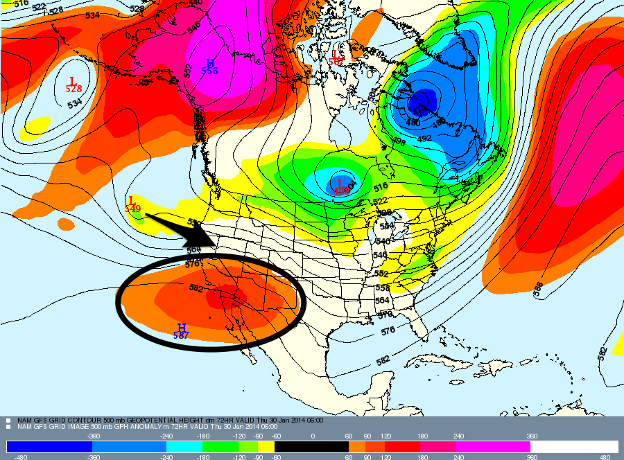
The ridge (circled) will breakdown beginning on Tuesday allowing for storms to move in off the Pacific. Source: Meteostar, analysis by OpenSnow.
This is amazing news for the Lake Tahoe region as their seasonal snow totals remain well below average. They will first see a chance for snow on Tuesday but totals look to be trace at best. They will then see a strong storm move through the region beginning on Thursday with moderate to heavy accumulations expected! Snow will likely stay falling throughout Friday and into Saturday. Brian will break it all down throughout the week in The Tahoe Daily Snow.
As for the rest of the West, double digit snow accumulations can to be expected Wednesday through Saturday. Thursday and Friday will likely be good powder days across the entire West. Even though the temperatures will be warmer than the previous storms, there will be a lot of moisture. This will be the main driver in bringing big totals as a lot of moisture usually means a lot of snow. The Idaho panhandle, western Montana, Wyoming, and Colorado look to have the highest accumulations when it's all said and done. Get all the details for the rest of the West in the Utah and Colorado Daily Snow. Pacific Northwest Daily Snow coming soon!
When you're up on the hill this week post pictures and updates using "LiveSnow", one of the features of our new iPhone and Android app. If you haven't already, download the iPhone version here and the new Android version here.
Always check our Powder Finder and the forecasts for each mountain throughout the week for more details.
Sam Collentine | OpenSnow
About The Author
Sam Collentine
Meteorologist
Sam Collentine is the Chief Operating Officer of OpenSnow and lives in Basalt, Colorado. Before joining OpenSnow, he studied Atmospheric Science at the University of Colorado, spent time at Channel 7 News in Denver, and at the National Weather Service in Boulder.
Free OpenSnow App


