News

By Sam Collentine, Meteorologist Posted 10 years ago March 10, 2014
Weather for the week - March 10 to March 14, 2014
For this week, a quick moving system will bring moderate to heavy accumulations to the northern Rockies and inter-mountain West while the East Coast eyes a potentially strong midweek storm. The heaviest snow will fall throughout Monday and into Monday night for the northern Rockies with Idaho, Western Montana, and the Tetons of Wyoming coming away with the highest totals. The major focus will then turn to the East where a very strong system is projected to develop Wednesday and into Thursday. If you are a powderhound in New England, Thursday could be a great day to call in sick.
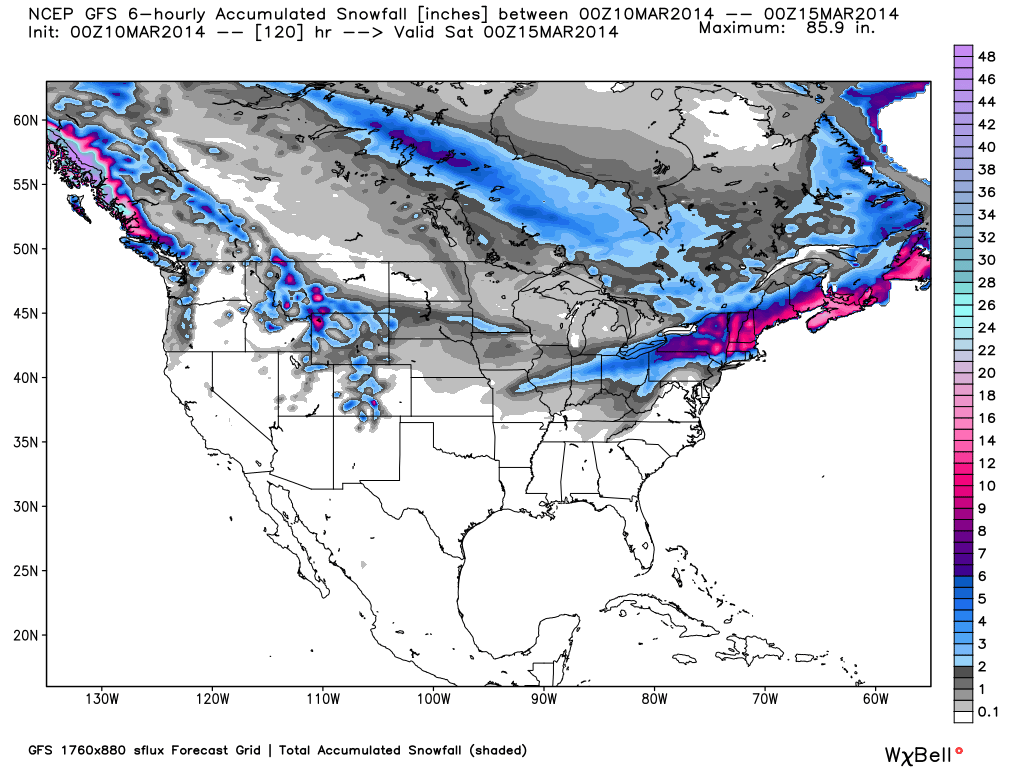
Total accumulated snowfall, according to the American GFS, through Friday night. Source: WeatherBell.com
West Coast
The Northwest will see moderate snowfall throughout the day Monday. The Oregon Cascades and central Idaho will come away with the best powder reports on Tuesday morning. Look to the higher elevated areas to find the best snow. Warm and dry weather will move in for the rest of the week with spring-like skiing. As the system moves farther south on Monday, the Lake Tahoe region will see light snowfall but accumulations will likely be 2-4" at best. Larry and Brian will have all the details, as well as a look at the extended forecast, in the Northwest and Tahoe Daily Snow.
Northern Rockies and Inter-Mountain West
As the system drops southeast out of the Northwest on Monday, western Montana and the Tetons of Wyoming will see moderate to heavy accumulations as the blunt of the moisture is confined to the region. Tuesday will be an excellent powder day for the northern Rockies with clearing skies moving in for the remainder of the week. As for Utah and Colorado, clouds will be on the increase throughout the day Monday as the system approaches. Utah will then begin to see snowfall on Monday night with a powder report of 4-8" come Tuesday morning. Northern Colorado will begin to see snow develop on Monday night with the rest of the state seeing the best accumulations throughout the day Tuesday. This storm has a good amount of energy (vorticity) so Colorado can expect to see a time of heavy snow during the late-morning or early afternoon hours on Tuesday. The rest of the week will be dry with the exception of a cut-off storm that could push light snow into the Southwest and southern Colorado on Thursday. Evan and Joel will have all the details in the Utah and Colorado Daily Snow.
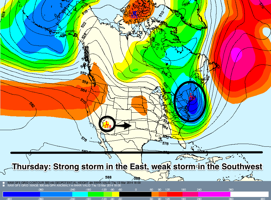
On Thursday, a strong storm is projected to bring heavy snow to many parts of the Northeast while a weaker system moves slowly east across the Desert Southwest. Source: Meteostar, analysis by OpenSnow.
Upper Midwest and Northeast
The Upper Midwest will continue to see mild and dry conditions through Tuesday ahead of system that will drop out of Canada on Wednesday. This will cool the temperatures dramatically and bring a light chance of snow to the region. Andrew Murray will break it all down in the Upper Midwest Daily Snow. The biggest weather story of the week is then projected to move into the Northeast late Wednesday night. The models have come into good agreement over the last 36-48 hours as this storm is likely to track up the East Coast bringing heavy snow to many parts of the Northeast. It's too early to get into exact snow totals but if everything stays the course, northern New England could see over a foot through Thursday. Brian Clark will break down all the details in the New England Daily Snow.
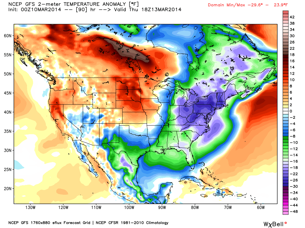
The temperature anomaly, or the departure from the long-term average, as of Thursday. Source: WeatherBell.com
When you're up on the hill this week post pictures and updates using "LiveSnow", one of the features of our FREE iPhone and Android app.
Always check our Powder Finder and the forecasts for each mountain throughout the week for more details.
Sam Collentine | OpenSnow
> Checkout Liftopia for Discount Lift Tickets
About The Author
Sam Collentine
Meteorologist
Sam Collentine is the Chief Operating Officer of OpenSnow and lives in Basalt, Colorado. Before joining OpenSnow, he studied Atmospheric Science at the University of Colorado, spent time at Channel 7 News in Denver, and at the National Weather Service in Boulder.
Free OpenSnow App


