News

By Sam Collentine, Meteorologist Posted 10 years ago March 20, 2014
Weather for the weekend - March 21 to March 23, 2014
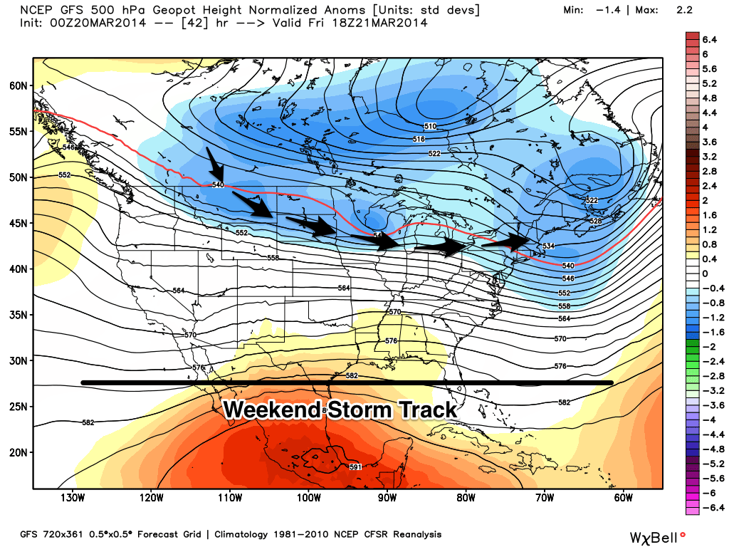
A relatively quiet weekend is in store for the majority of the United States as the main storm track pushes north. A warm area of high pressure will build over the western United States on Friday pushing temperatures above average across the Northwest and Lake Tahoe. This is not before a quick system pushes down the central Rockies on Friday bringing light to moderate snowfall across Colorado. The northern storm track this weekend will make Montana the place to be to find the deepest powder as decent accumulations take aim at the state. Spring may officially be upon us but there is still plenty of great skiing to be had!
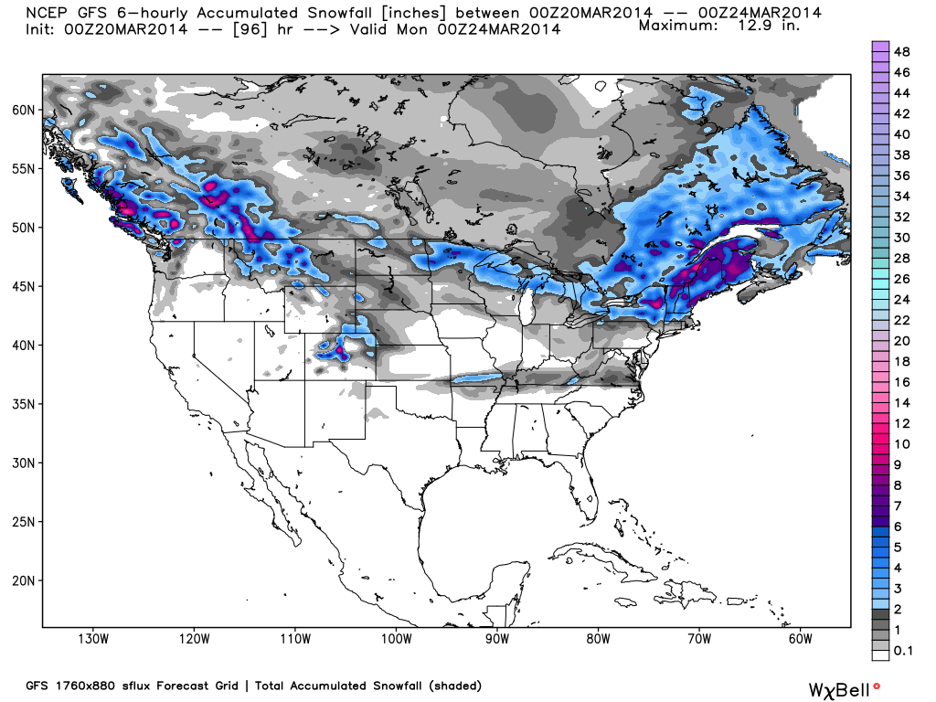
Total accumulated snowfall, according to the American GFS, through Sunday night. Source: WeatherBell.com
Northwest
After a good week of snow across the Northwest, sunny skies and warm temperatures will move into the region beginning on Friday. Spring skiing will be in full effect all weekend so grab the sunscreen and soak in the sun! There is a slight chance for light snow throughout British Columbia and possibly into Washington beginning on Saturday night but it will likely stay north. Enjoy the sun and head over to The Northwest Daily Snow for the latest details.
Inter-mountain West
Montana will be the winner this weekend as the main area of storm energy pushes across the state on Friday night and into Saturday. Totals will range from 4-8 inches through Saturday night. A quick moving system will also take aim at Colorado on Friday night with lighter totals expected. The storm energy will be somewhat weak so I expect 2-4 inches for most areas through Saturday night. This will soften up conditions but expect a lot of crunch underneath, especially on the south-facing slopes. In other news, Colorado is at 104% of peak seasonal snowpack so if it doesn't snow another flake this season, it would still be considered an above average year! If the state continues to see decent accumulations throughout the rest of March and into April, we could be talking about one of the best years on record. Evan and Joel will break down all the details throughout the weekend in the Utah and Colorado Daily Snow.
Besides a quick system that will bring snow to the Colorado Rockies, the main storm track will stay north pushing storms across Montana, the Upper Midwest, and the Northeast. Source: WeatherBell.com, analysis by OpenSnow.
Upper Midwest
The Upper Midwest will stay under an active pattern that will bring a light storm or two throughout the weekend. 1-3 to 2-4 inches can be expected on Friday for parts of Minnesota, Wisconsin, and Michigan. A mixed precipitation will be found the further south we look as temperatures will be on the warmer side. Another storm will begin to push into the region on Sunday night with a VERY cold storm possible during the beginning to middle of next week. Andrew will have the details in The Upper Midwest Daily Snow.
Northeast
Winter is definitely not over in the Northeast as storm after storm continue to take aim at the region. After a break on Friday, another system will push into the region on Saturday mainly affecting New England. 1-4 inches and possibly more will likely accumulate across the New England region but also into parts of the Mid-Atlantic. Just like the Upper Midwest, the further south we go the more likely we will run into a mixed precipitation. Stay north and in the highly elevated areas and you will find great skiing. Brian will have further details in The New England Daily Snow.
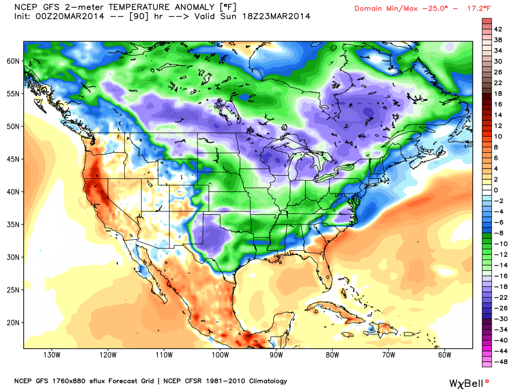
The temperature anomaly, or the departure from the long-term average, as of Sunday. Above average temperatures will be found across the West Coast with below average temperatures across the central and eastern United States. Source: WeatherBell.com
When you're up on the hill this weekend post pictures and updates using "LiveSnow", one of the features of our FREE iPhone and Android app.
Always check our Powder Finder and the forecasts for each mountain throughout the weekend for more details.
Sam Collentine | OpenSnow
> Checkout Liftopia for Discount Lift Tickets
About The Author
Sam Collentine
Meteorologist
Sam Collentine is the Chief Operating Officer of OpenSnow and lives in Basalt, Colorado. Before joining OpenSnow, he studied Atmospheric Science at the University of Colorado, spent time at Channel 7 News in Denver, and at the National Weather Service in Boulder.
Free OpenSnow App


