Chase Powder Daily Snow

By Powderchaser Steve, Forecaster Posted 5 years ago January 20, 2019
Updated Forecast for POW= Both east and west- 1-2 feet
Update
This will be brief as I am on the chase! New England is underway with snow just entering western Vermont. Models show a very consistent 15-20 inches among most areas with a few caveats. The central or southern portions of Vermont and NH will be deepest by daybreak and the north may catch up by your last chair Sunday. Maine will score the deepest snow late tonight through Sunday evening. Northern VT may see some wrap around additional snow Sunday night with NW winds. Temps will be cold for this storm and conditions will be epic Sunday and perhaps Monday in northern Maine? Northern VT is a wildcard for Monday with additional snow?
Below: "YOU CAN'T MESS THIS CHASE UP" Ride Sunday!

The Sierra grabs a wet storm above 7,000 feet Sunday/Monday. Expect 6-11 inches through Sunday and another 4-8 inches for Monday (Better quality) with colder air! Best turns will come late Sunday above 7,000 feet or early Monday above 5,000 feet.
In the Rockies expect moderate to heavy snow with unfortunately warm air over central Idaho (Brundage), Sawtooths (Sun Valley) extending into the Tetons late Saturday/Sunday. All of these areas may see 5-10 inches with warming temps may destroy quality by late AM or early afternoon. It's chaseable but stick to higher elevations. Colder air will exist in northern Montana with better quality (Winter like) over Whitefish Sunday (4-8). In southern Montana, temps are on the warm side with light or moderate snow for Big Sky. I like the totals in the next 24 hours but do not like temps (Exception being northern Montana).
A stronger system moves over the Rockies Sunday night-Tuesday. Current models show 6-12 inches or more for the Tetons (Colder) with your best day to ride on Monday. The Wasatch in Utah has flip-flopped some on the models. Currently, they show higher amounts in the northern ranges of the State extending into Wyoming.
Colorado gets action late Monday midday into Tuesday favoring the north/central mountains (Moderate).
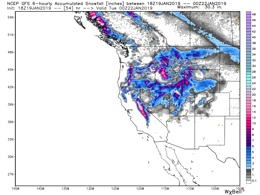
Below: Total snowfall for the west through Monday PM. Highlights in central and southern Idaho, Sierra, and the Tetons. Wasatch is slightly less but orographics and colder temps may overperform?
Powderchaser Steve
About Our Forecaster
Powderchaser Steve
Forecaster
Powderchaser Steve has over 45 years of experience chasing storms based on his weather and local knowledge of resorts on both the East and West Coasts. His snow intel will likely land him at the deepest resort and almost never missing "First Chair" in the process. Follow "The Chase" on OpenSnow to find out where the deepest snow may be falling.
Free OpenSnow App


