Colorado Daily Snow

By Joel Gratz, Founding Meteorologist Posted 4 years ago August 14, 2019
Getting cooler, but cold enough to snow?
Update
Welcome to mid-August!
We are over the hump of summer and descending into the cooler temperatures of late August. Of course, it’s still reasonably warm outside. But the average temperature graph below shows that peak warmth is usually in late July, and we are now solidly on the downswing.

10-Day Forecast for August 14-23
There will not be a lot of exciting weather for the next ten days.
While there will still be occasional afternoon and evening thunderstorms on some days, the overall weather pattern will be for drier-than-average conditions.

And there won’t be much excitement in the temperature department either, with NO cold spells heading toward Colorado for at least the next 10-ish days. The colder-than-average air will generally stay just east of the Rocky Mountains, extending from northern Canada southeastward into the Upper Midwest.
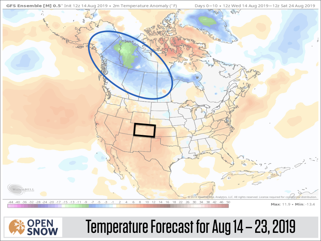
With below-average precipitation and above-average temperatures in the 10-day forecast, there is basically no chance for any widespread pre-season snow here in Colorado. The best chances for at least a few inches of snow will be in Northwest Canada, which is typical for this time of the year.

Forecast for the Upcoming Season
We are about two months from opening day at a few ski areas, about 3 months from opening day for most ski areas, and 4-5 months away from the meat of the season.
But that doesn’t stop the hype, as I have seen a lot of longer-range winter forecasts being published over the last week or two.
Here’s the deal. These long-range forecasts (many months into the future) have little to no accuracy in general and are totally useless when it comes to figuring out which month or which week will offer the best powder.
Now in August, most forecasters are focused on El Nino or La Nina and how this might impact the coming winter. While El Nino or La Nina do correlate in some ways with above-average or below-average snowfall, they are FAR from perfect predictors.
For the 2019-2020 season, the best chance is for NOT an El Nino, NOT a La Nina, but “Neutral” conditions. In other words, the ocean water temperature in the central Pacific Ocean will likely close-ish to average.

In future posts, I will dig into some past seasons that featured Neutral El Nino / La Nina conditions to see if history can be a guide to our upcoming season.
Throwback to June 2019
It was just two months ago when we were skiing on the summer solstice!
The images below compare Arapahoe Basin from June 2018 to June 2019. Whoa, what a difference! Thanks to Arapahoe Basin COO Alan Henceroth for posting this comparison!

Next Post
From now on, I’ll write weekly updates covering the week-ahead forecast, the longer-range outlook for any colder air heading our way, and will also touch on seasonal forecast updates (remember that I do NOT find much value in 6+ month predictions!).
Thanks for reading!
JOEL GRATZ
PS – Our summer service, called OpenSummit, offers hourly forecasts for over 1,000 mountains around Colorado and the United States. Our goal is to help you plan your hiking, biking, and climbing adventures to avoid lightning, precipitation, and strong winds. Check out the OpenSummit website, iOS app, and Android app.
About Our Forecaster
Joel Gratz
Founding Meteorologist
Joel Gratz is the Founding Meteorologist of OpenSnow and has lived in Boulder, Colorado since 2003. Before moving to Colorado, he spent his childhood as a (not very fast) ski racer in eastern Pennsylvania.
Free OpenSnow App


