Tahoe Daily Snow

By Bryan Allegretto, Forecaster Posted 10 years ago February 8, 2014
Update 4:30 PM:
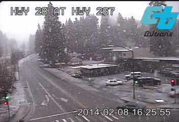
Forecast models are blowing it in a good way today. Snow levels sat between 6700-7000 ft. all day. We picked up 7 inches up here at the office today on Donner Summit bringing the 3 day total to 27 inches. Sinking in past the knees walking in the yard. The temperature reached 32.3 degrees this afternoon but fell to 31.9 in the last hour. Our exact elevation is around 6910'. Reports coming in the last half hour of snow down to lake level on the North side of the lake and mixing with snow on the South side. Looking at the caltrans webcam the ground is turning white at lake level in King's Beach.
The forecast models show that the highest snow levels will occur between about 4 p.m. today and 4 a.m. Sunday. With the snow levels lowering as of 4:30 not sure the snow levels will come up that much above 7000 ft. if they do rise. We'll have to keep watching. The heavy precip is helping to drag the cold air down to the surface. Posting up to the minute updates and pics on the "Tahoe Weather" Facebook page. Still expecting snow levels to lower during the day Sunday.
Stay tuned.....BA
From This Morning:
Summary:
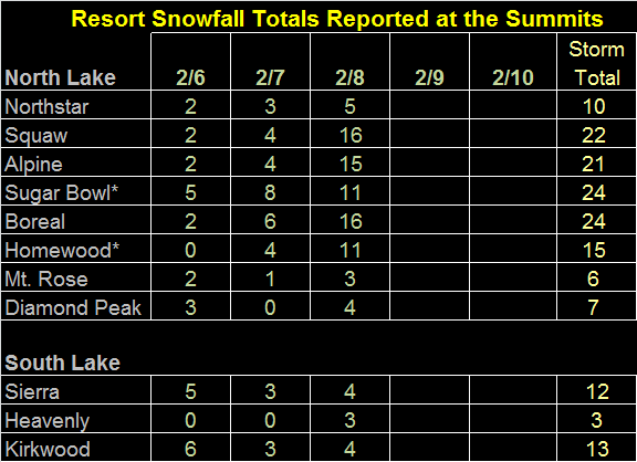
The ski resorts NW of the lake along the crest are reporting 11-16 inches up top in the past 24 hours. The rest are reporting 3-5 inches. Snow levels are running near 7000 ft. this morning. The heaviest precip of the weekend will push in today and Sunday. Snow levels are expected to rise near or just above 8000 ft. this afternoon and tonight before falling back near 7000 ft. during the day Sunday. Expecting several inches of rain below the snow line and several feet of snow above it.
The precip clears out Monday with the next chance for light rain and high elevation snow Wednesday into Thursday. Possibly a colder system for President's weekend.
Details:
The main jet stream was to our North yesterday so there wasn't much to help push the precip into the Tahoe basin. Most of the heavy precip got stuck up along the crest. The temperatures held steady most of the day and then they started to rise last night with snow levels jumping above lake level prior to midnight. About 6 hours faster than expected. A dry slot also moved in overnight bringing a break in the heavy precip even along the crest. Putting all those factors together the snowfall was very limited in the Tahoe Basin the first 24 hours of this storm. The mountains East of the Western crest and South of the lake are only reporting 3-5 inches of snow in the past 24 hours.
Up along the crest NW of the lake heavy precip fell most of the day yesterday. The ski resorts in this area from Sugar Bowl down to Squaw & Alpine down to Homewood are reporting 24 hour snowfall amounts of anywhere from 11-16 inches up top, more in line with the forecast for 1-2 feet. These resorts have all picked up close to 2 feet for 3 day totals. So a big discrepancy in snowfall along vs East of the crest. We picked up 5 inches yesterday up here in front of the office at 7000 ft. on Donner Summit, and another 6 inches overnight bringing out 24 hour total to 11 inches and 3 day total to 20 inches.
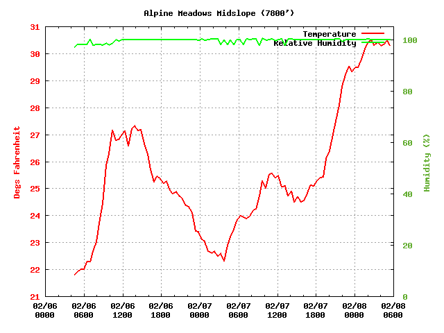
The temperatures rose most of the night but have leveled off in the early morning hours. We have held steady here on Donner Summit 7000 ft. at 31.6 degrees the past couple of hours with the snowfall picking up again. The snow levels look to be near the freezing levels at 7000 ft. which is what we talked about happening with the saturated airmass. The snow has become much heavier and wetter overnight. Here are the temp up through 6 a.m. at 7800 ft. on Alpine. Holding steady around 30.4 degrees.
The heaviest precip yet is pushing onshore into CA. Looking at the forecast modles liquid output through Monday morning there is only about an inch less than yesterday morning. That means the majority of the precip is going to fall today and tomorrow. We could still pick up 2-3 inches of liquid in the basin with 3-4 inches on the mountains, and up to 5 inches along the crest. It's still a wait and see with the snow levels. They shot up above lake level pretty fast last night prior to midnight, but they are holding steady this morning at or just below 7000 ft. They are expected to rise this afternoon with the heavier precip up to 8000 ft. and possibly just above that going into tonight.
Sunday will be interesting as the jet stream pushes from just to our North, Southward across the area. This will help to push the heavier precip into the Tahoe Basin and will start to lower snow levels. This isn't a strong cold front like we see a lot where snow levels crash. They will slowly fall and may not make it to lake level until the early morning hours Monday before the precip ends. They should drop down close to 7000 ft. Sunday with some models showing it happening faster Sunday morning and others not until the afternoon.
It will be hard to say how much snow will fall today from 7000 ft. up to 8000 ft. as we don't know how fast the snow levels will rise. We could see several inches West of the lake before a changeover. Then on Sunday it's hard to say as well. If the snow levels wait until Sunday night to fall to 7000 ft. we may only see several more inches. If they fall faster we could see over a foot of snow. Above 8000 ft. where it stays all snow we still expect another 2-3 feet East of the crest and 3-4 feet along the crest West of the lake by Monday morning. This will be heavy wet base building snow which we need.
The precip tapers off Monday morning and we have a break on Tuesday. The forecast models have trended further North again with the moisture plume Wednesday into Thursday. We are now back to being on the Southern fringe of the precip. This will be a light rain event with snow above 8000 ft. There is also not much forcing with the jet to the North so most of the precip looks to fall along the crest. We will have to keep watching in case the models trend further South with the heavier precip.
Long-Range:
The models continue to hint at a colder system next weekend. The Canadian and European models are currently the most aggressive with this. Something to watch this week. We will be ready for some colder snow after this base building snow on the mountains.
The pattern still looks like it could get colder the last week of the month. We will look at that more after this storm.
Stay tuned, and stay dry....BA
About Our Forecaster
Bryan Allegretto
Forecaster
Bryan Allegretto has been writing insightful posts about snow storms for over the last 15 years and is known as Tahoe's go-to snow forecaster. BA grew up in south Jersey, surfing, snowboarding, and chasing down the storms creating the epic conditions for both.
Free OpenSnow App


