Tahoe Daily Snow

By Bryan Allegretto, Forecaster Posted 9 years ago April 23, 2014
Summary:
Nice weather today. Sunny with increasing winds Thursday. A cold system moves in Friday with snow. Snow showers could linger on the mountains through the weekend. We return to Spring weather next week.
Details:
A few more inches of snow fell yesterday along the crest. We ended up with around 4 inches on the deck on Donner Summit. Squaw and Alpine are reporting a storm total of 7 inches up top and Kirkwood 6 inches. That is at the high end of the forecast
Not much has changed in the past day regarding the details of the system for Friday. The forecast models are in agreement that several inches of snow will fall on the mountains. They are still not in agreement on where the highest amounts will fall. The snow may begin to fall later Thursday night along the crest, but the heaviest snow across the basin is expected on Friday as the cold front pushes through. With the snow falling during the day it will limit the impacts at lake level. Snow showers lingering into Friday night could drop a coating of snow.
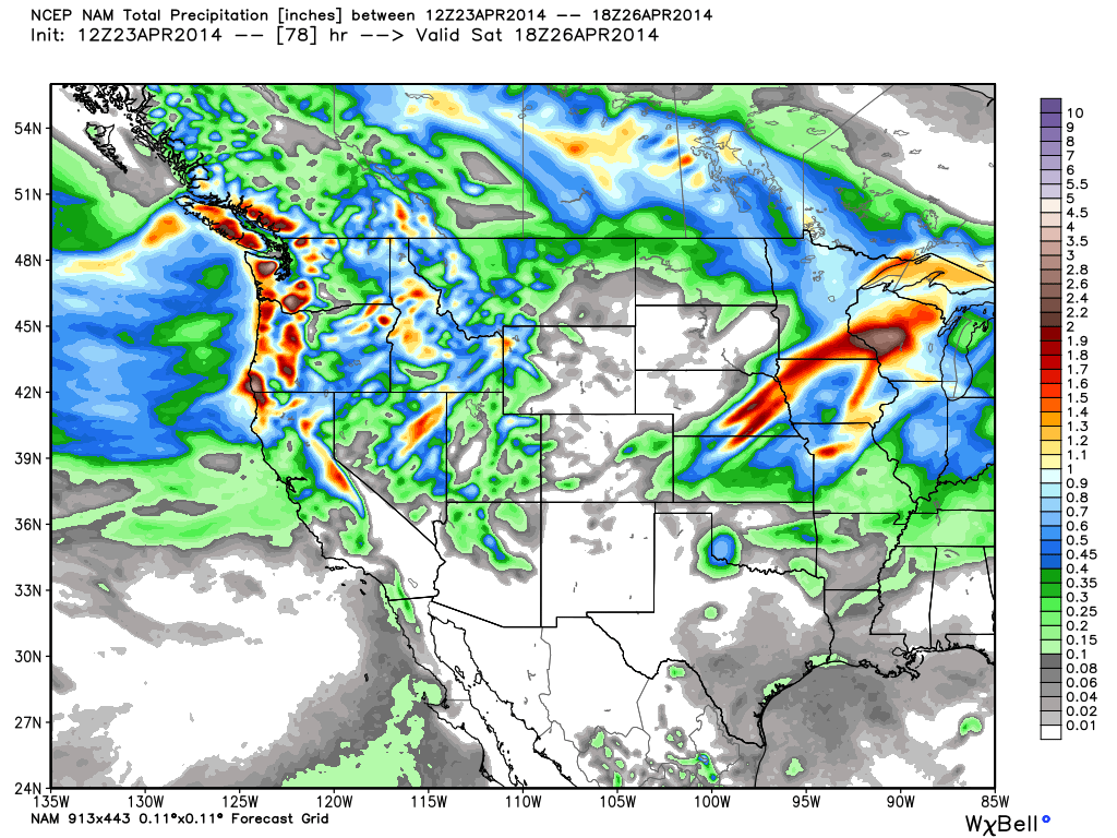
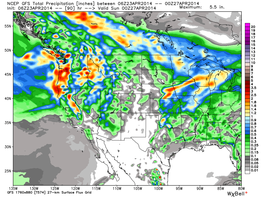
The models are showing differences in where the jet streak comes inland Friday enhancing snowfall. Also where or whether or not the cold front slows and drops higher totals. You can see the differences in the precip forecasts. The European model is the furthest South with the bullseye of heaviest precip, South of Mammoth. The NAM is further North centered near Mammoth.
The GFS which was showing the system splitting and the heavier precip to our South is now holding it together and has the heaviest precip just Southwest of the lake.
Total liquid amounts of up to 2 inches are possible where the heaviest precip falls. With the heaviest precip to our South the models are in agreement that the cold front and post frontal showers could drop 3-6 inches on the mountains on the East side of the lake and 6-9 inches on the West side, with up to a foot along the crest. Amounts could be higher if the jet streak comes inland further North or if the cold front stall for a while across the basin. Right now the best chance for higher amounts looks to be Kirkwood and South towards Mammoth.
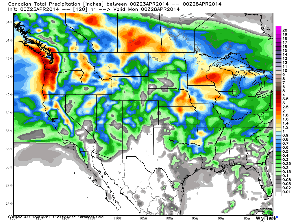
The Canadian model which showed several inches of liquid from the combination of two system this weekend is the weakest now with the first system. It however is the furthest South with the second system for Sunday. The GFS has the ridge building off the coast Saturday and keeps the system to our North. The Euro brings us more light snow Sunday on the mountains. The Canadian is far enough South to bring a few more inches of snow on Sunday. Here is the Canadian precip forecast for both systems showing totals similar to what the other models show with just the first system.
The temperatures will be coldest Friday with highs only in the 30's at lake level and 20's on the mountains. Highs over the weekend will be in the 40's at lake level and 30's on the mountains. Snow showers could linger through the weekend on the mountains if the second system is far enough South.
Long-Range:
The ridge builds in quickly by next Monday with temperatures jumping back into the 60's. After a final weekend of skiing at Squaw or Kirkwood with fresh snow it may be back to T-Shirts and Spring activities next week. There are some signs that we could see some active weather again the week of the 5th, but that is pretty far out right now.
Stay tuned....BA
P.S. some of you have mentioned the big swings in the snowfall forecasts for the ski resorts on the forecasts page. That is because I switched it to automated for the rest of the season. They are now tied to the forecast models which change with each run, like the forecasts on many other weather sites that are automated. I will resume hand typed snowfall forecasts for each resort when they open again next Fall.
About Our Forecaster
Bryan Allegretto
Forecaster
Bryan Allegretto has been writing insightful posts about snow storms for over the last 15 years and is known as Tahoe's go-to snow forecaster. BA grew up in south Jersey, surfing, snowboarding, and chasing down the storms creating the epic conditions for both.
Free OpenSnow App


