Tahoe Daily Snow

By Bryan Allegretto, Forecaster Posted 8 years ago January 5, 2016
Weeks of Weak...
Summary:
Snow will push into the Tahoe basin today bringing several inches of snow to lake level and up to a foot of snow on the mountains. We should see a break tonight before the next storm moves in Wednesday. This storm could bring us similar amounts of snow. Then on Thursday the last weak wave moves through and could bring a few more inches of snow. Friday we should have a break before another weak storm could bring several inches of snow over the weekend.
Temperatures will remain in the low 30's at lake level through the period and in the 20's on the mountains. The winds will be gusty with the storms and will relax in between storms on Thursday and Friday. Next week we could continue to see weak storms bring more snow.
Details:
A few adjustments to needed to be made this morning. The forecast models are a little wetter with the Wednesday storm so I have increase the snowfall forecast for Wednesday. The storms look a little colder so I have adjusted snow ratios up slightly. The winds look a little weaker but still pretty strong on the ridges near 80 mph gusts possible. The wave for Thursday looks to bring a bit more snow as well.
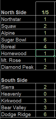
We saw light snow yesterday and overnight from the weak storm that moved through. The snow had a hard time pushing over the crest into the basin as expected. Resorts East of the crest picked up 1-2 inches as of this morning, and West of the crest 3-6 inches.
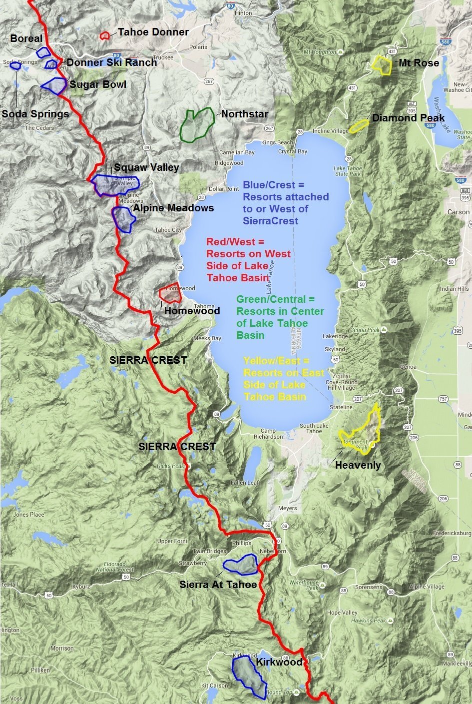
As a reminder here is a map of Tahoe, but you can also lake at the Tahoe page and correlate the resorts to the forecast.
The next storm is moving in this morning. It has begun snowing but the heaviest precip is still struggling to push over the crest into the basin. We should see it push in during the day today. The GFS continues to much wetter than the other models with both storms. The Canadian is still the driest, and the NAM model is showing similar amounts with both storms as the European model.
Taking the GFS/Euro average here is the final snowfall forecast for today's storm.
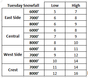
The snow should taper off tonight with a brief break between storms. Then on Wednesday the next storm moves in bringing snow into Wednesday night. The forecast models have trended wetter with this storm over the past 24 hours. Here is a look at the snowfall forecast for the 2nd storm through Wednesday night.
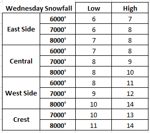
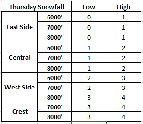
The amounts are similar to the first storm. Then on Thursday into Thursday night the center of circulation with the low that pushes in the Wednesday storm dives Southeast into CA. The forecast models were driving it further South and mostly missing us the last couple of days, but this morning they have the precip far enough North to bring us some additional snowfall. We will have to keep watching the track of this for Thursday, but here is the potential snowfall as of this morning.
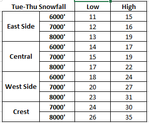
And the grand total snowfall forecast for the 3 waves by Friday morning, drum roll please......
When you plug in just the GFS the amounts are higher and just the European and the amounts are lower. Like I mentioned above the Canadian is drier than the European model, and the NAM is close to it. Here is a look at the difference in total precip by Friday between the GFS and European models.
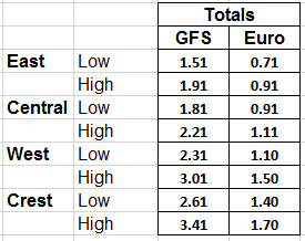
So I would lean towards the lower end of the snowfall forecast of 1-2 feet on the mountains by Friday. If the GFS is somehow right even though it's the outlier than we could be in for a nice surprise of 3+ feet along the crest. You would normally see a little more agreement this close to the event.
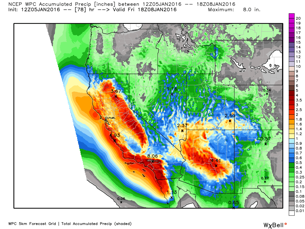
Here is a look at the updated WPC total precip forecast this week. You can see the heaviest precip dives towards Southern CA where the jet stream is aimed. That is where they need the rain the most.
We should have a break on Friday before another weak storm tries to push in over the weekend. The GFS has been trending towards splitting the storm apart with not much precip making it into the Sierra. The European runs however have been trending more consolidated with several inches of snow this weekend. Either way not a big storm, but we will keep watching the trend.
Long-Range:
Next week the trough deepens in the East and the ridge builds over the West which will make it harder for storms to hold together as they try to push into the West Coast. The AO (Arctic Oscillation) is negative which is releasing the cold air South over the continent and the NAO (North Atlantic Oscillation) is going negative, while the PNA (Pacific North American) teleconnection is positive. This is the recipe we had the last few Winters where the cold drops into a trough over the Eastern U.S. and locks in while the ridge builds over the West and gets locked in place. The obvious difference this Winter is the the strong El Nino and strengthening Pacific jet stream that will try to push storms into the West Coast on the back side of the Western ridge.
After the storm door into CA is open this week that will be the change for next week. Storms will weaken and split as they encounter the Western ridge. There looks to be 2 storms for next week on Tuesday and Thursday that will try to push into CA. They should bring us precip but how much is in question as they weaken and split.
Here is a look at the pattern by the middle of next week, you can see the trough trying to push into CA.
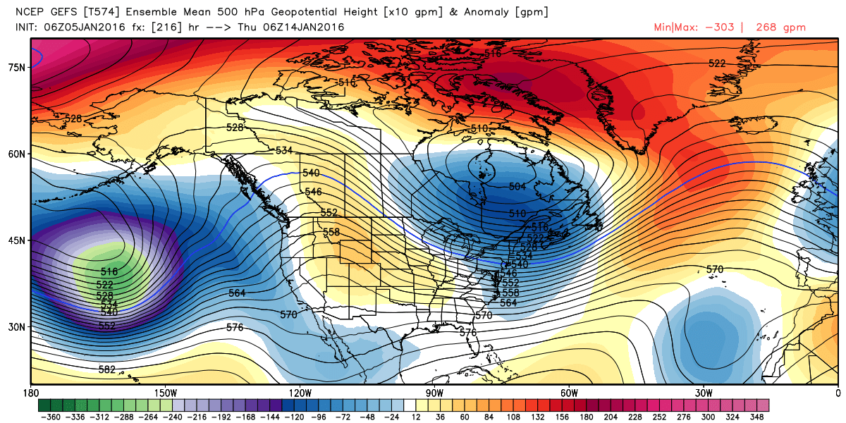
Then by the end of next week the ridge may build in stronger along the West Coast bringing a break in the storms making it into CA.
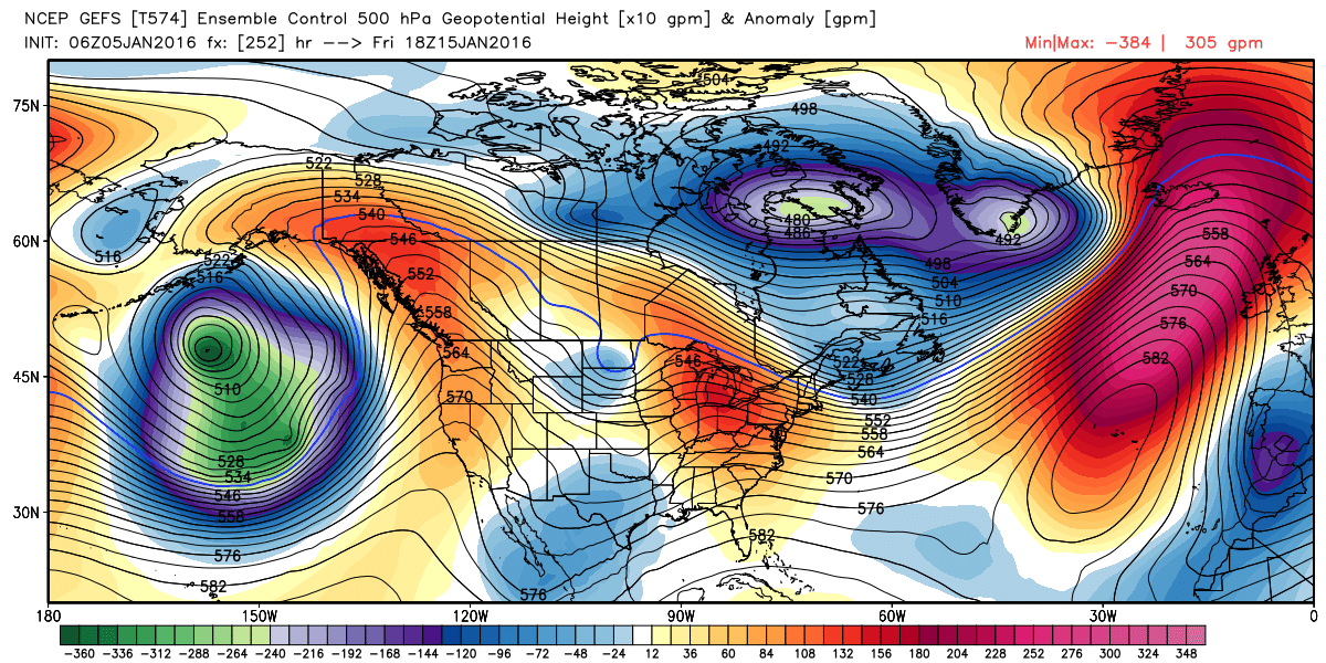
Looking way down the road it looks like we may see that big trough in the Eastern Pacific push closer to the coast by the 20th. Any big storms may hold off until then.
January is historically the wettest month of the Winter even though that has not been the case the last several years. Especially in a strong El Nino we would expect to get some heavy precip in January. Each day that goes by this time of the year without precip we quickly fall behind average. The break in storms over the last week already dropped us down to 88% of average precip for the water year in the Northern Sierra. We are way behind this time last year.
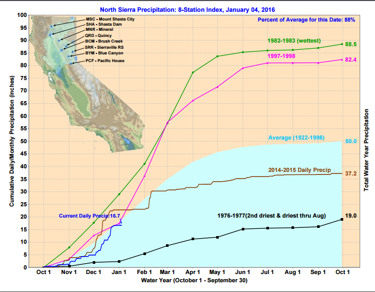
Last year the precip stopped in January and after a big storm to start February completely stopped. Not expecting that to happen this Winter as the storms should continue even if they are weak. The storms this week should get us back close to average and then we will see what happens next week. Hopefully the ridge is weak enough to allow the storm to push precip into CA.
I have been cautiously optimistic about this Winter, so that continues for now. I won't be happy until we at least get to average snowfall on Donner Summit. The average is 411 inches and we have 123 inches so far officially at the snow lab plus a few from yesterday. We have some big snows to get to later in the month and the rest of the Winter hopefully.
Stay tuned...BA
About Our Forecaster
Bryan Allegretto
Forecaster
Bryan Allegretto has been writing insightful posts about snow storms for over the last 15 years and is known as Tahoe's go-to snow forecaster. BA grew up in south Jersey, surfing, snowboarding, and chasing down the storms creating the epic conditions for both.
Free OpenSnow App


