News

By Joel Gratz, Founding Meteorologist Posted 9 years ago August 25, 2014
Another snow forecast for the 2014-2015 winter
For the record, I do not like long-range seasonal forecasts because they're usually not accurate. For proof, see the end of this post.
When a forecast is not accurate, you can't use it to plan, so it's not very helpful. This is why I like to wait until 7-10 days before a storm to estimate the general timing and location of a storm's snowfall, then refine the forecast until 2-3 days before the powder day, because that's when the forecasts become much more accurate.
That said, it's late August and we're a few months away from ski season, so we might as well look at the long range forecasts, mostly for entertainment value.
To start, there will be an El Nino this winter. For more about El Nino and what it might mean for snowfall over the next 6 months, read this article that I wrote last week.
While El Nino is a major factor that will determine snowfall patterns this winter, long-range weather models take into account many other variables when making 3-9 month forecasts. So let's look at what some of these long-range models say will happen between December and February.
Since we know that long-range forecasts aren't that reliable, forecasters try to stay away from looking at just one model's forecast and instead take an average of many models. This "ensemble" approach to forecasting can be more accurate than putting all of your forecasting eggs in one model basket.
So, without further ado, here's the winter forecast from an ensemble (group) of models that were made in the US, and another ensemble of models from other countries.
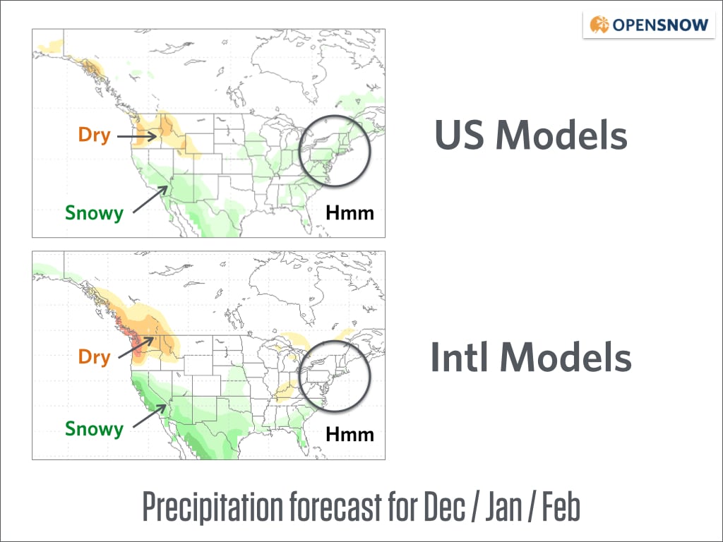
In general, the model ensembles show a similar forecast with snowy weather in the southwest, dry weather in the northwest, and snowy/rainy weather in the southeast. The model groupings differ for the northeast, however.
These forecasts look rather credible to me because they are similar to how El Nino generally impacts snowfall across the country.
However, remember that these ensembles are just averages of many models. It's also useful to see the forecast from each individual model. If the individual model forecasts are similar to one another, we have more confidence in the overall forecast. But if they've very different, than averaging together a wide variety of forecasts can provide a false sense of certainty and confidence.
So, what do the seven individual forecasts that make up the US ensemble look like?
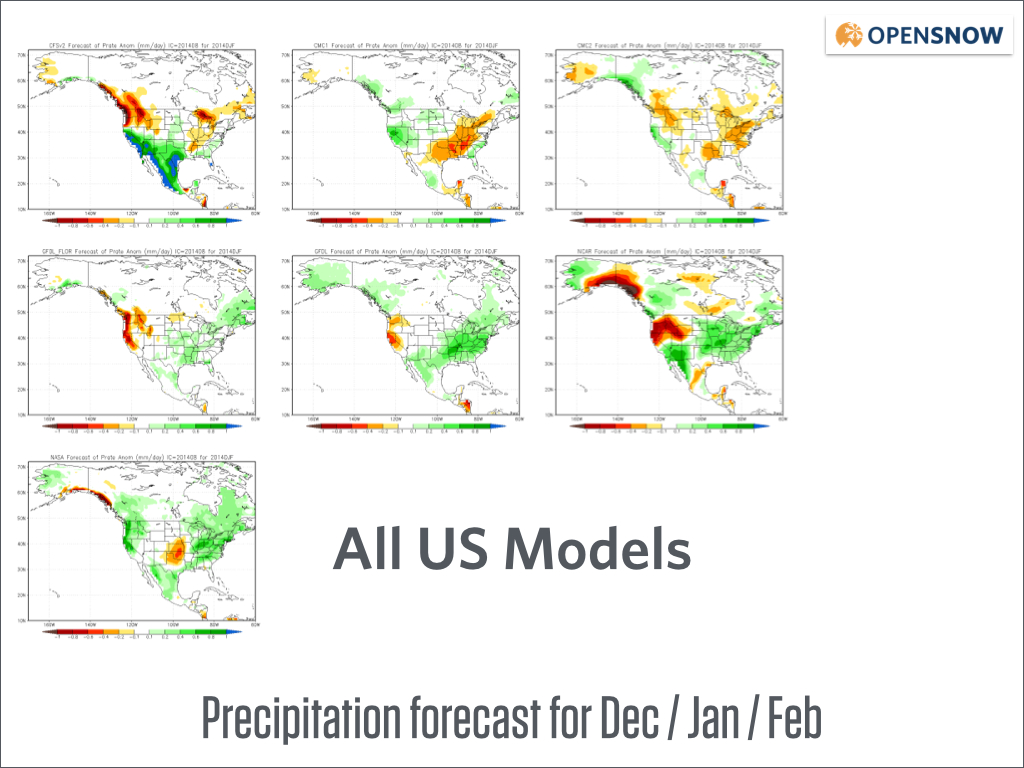
All of the models show average to above average snowfall (green colors) for various parts of the southwest, so that's a pretty good bet.
Five of the 7 models (71%) show below-average snowfall for the northwest, so that's also a pretty good bet but definitely not a certainty.
Four of the seven models (57%) show above average snowfall for Tahoe, while three of the seven show below average snowfall. In other words, "We don't know!"
For Utah and Colorado, four of the seven models show this area as being on the edge of below-average snowfall, while other models show no preference for above or below average snow. So again, "We don't know!"
And in New England, the models are about split between below average, average, and above average snowfall. A roll of the dice.
Whether you like these forecasts or not, you may be wondering, "Why should I trust these models anyway?" That's a good question, and one that too many forecasters ignore.
One way to assess the trustworthiness of the models is to compare their forecasts with the snowfall patterns that usually result during an El Nino year. If the patterns match the models, confidence in the models increases. If the patterns don't match, then we're left scratching our heads and should likely put lower confidence in any long-term forecast. For the upcoming winter, these model forecasts generally do match snow patterns during an El Nino, so my confidence is decent.
Another way to assess the models is by looking back in time to understand the accuracy of their past forecasts. So let's do that.
Here is the US model ensemble forecast for last winter. Specifically, the forecast was made in August 2013 and covers December 2013, January 2014, and February 2014. The bottom image shows the actual precipitation during this time.
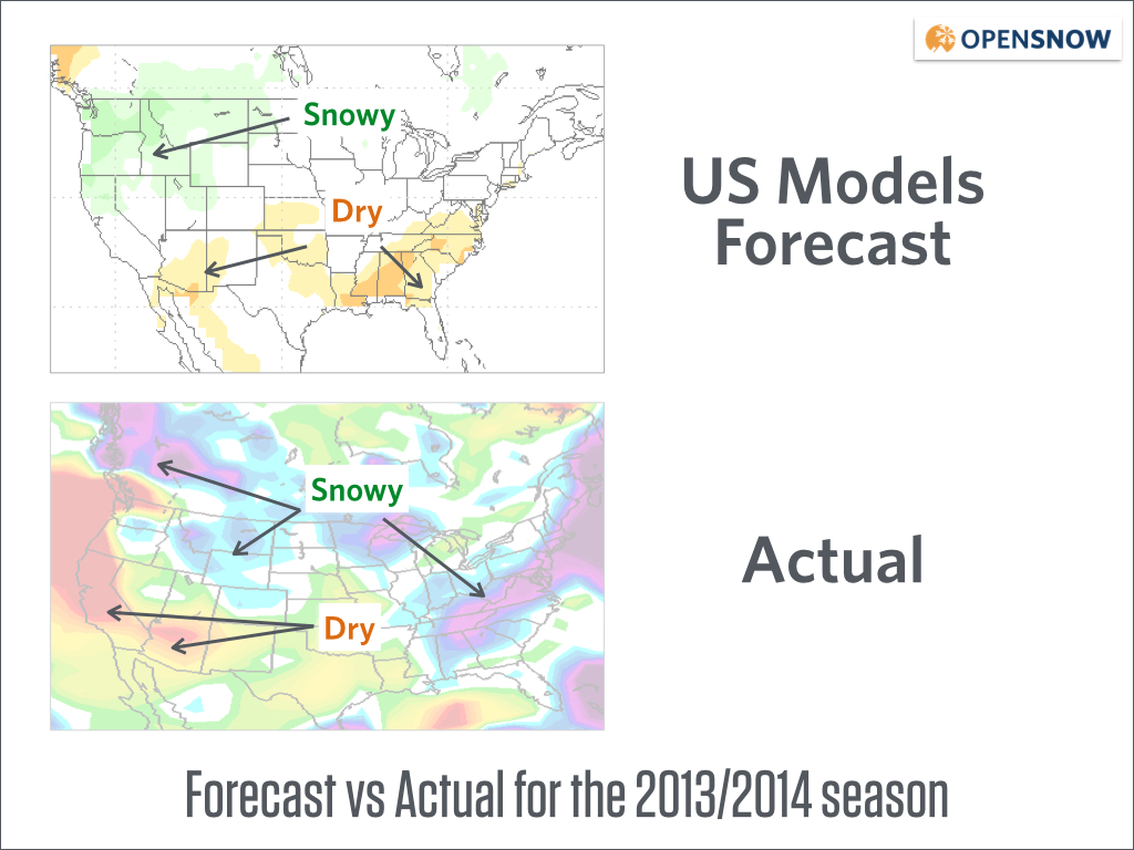
The result of the forecast? The average of the US models provided a very bad forecast.
It incorrectly forecasted above average snow in the northwest and Tahoe while snowfall was below average.
It correctly forecasted the above average snow around Montana, Wyoming, and northwest Colorado, but was incorrect for the southeast and mid-Atlantic where it forecasted below-average precipitation while in actuality the area was hit with heavy snow.
Moving on, did the International model ensemble do a better job?
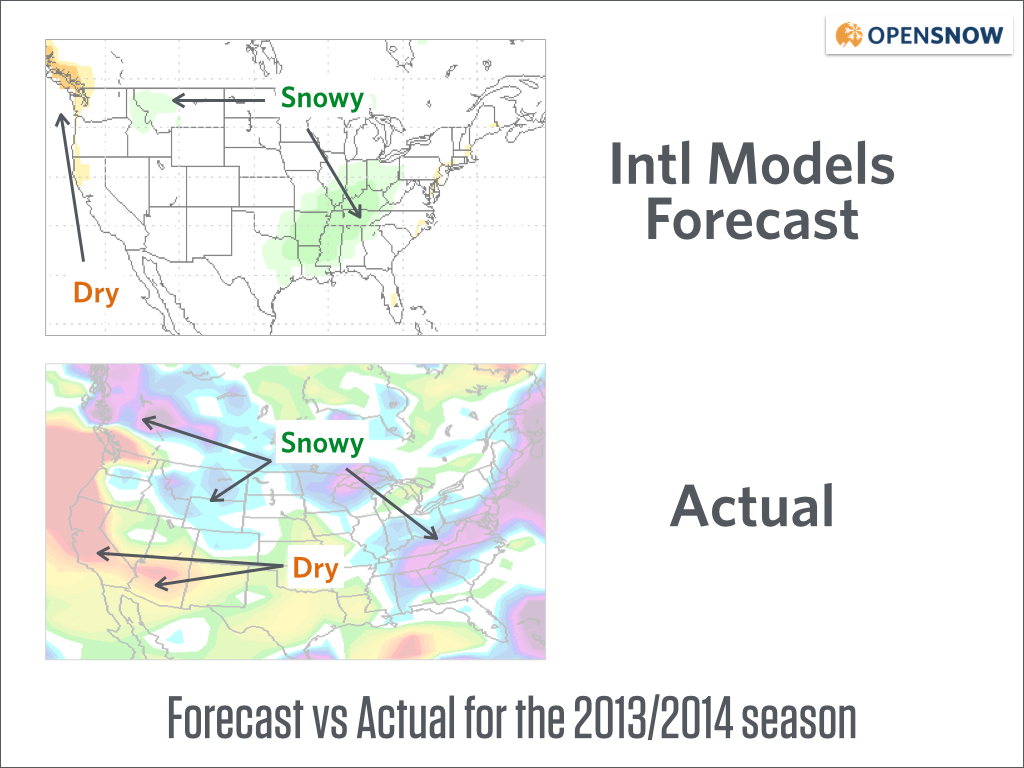
Yes, the international model ensemble was a bit more accurate, but far from perfect.
It hinted at below average precipitation along the west coast, but wasn't nearly bold enough to forecast the dryness that actually transpired.
And it also showed above average precipitation in the eastern US, but the location was wrong by ~400 miles as the heavier precipitation was along and east of the Appalachian mountains, not in the Mississippi River valley. Four hundred miles might not seems like a big distance for a model that covers the entire globe, but it's a big deal to a ski area that is only a couple of miles across, at most.
So, can we trust the seasonal forecasts from these models?
Based on last year, definitely not. However, since there will (should!) be an El Nino for the upcoming season, long-range forecasts can be a bit more accurate because El Nino forces the weather to behave in somewhat more predictable ways.
For now, treat all of this as entertainment and not a cause for celebration or as an excuse to grab a beer due to despair. It's still August, which means that you should go out hiking or biking and get strong for the snow that we hope will come in deep for the winter ahead.
About The Author
Joel Gratz
Founding Meteorologist
Joel Gratz is the Founding Meteorologist of OpenSnow and has lived in Boulder, Colorado since 2003. Before moving to Colorado, he spent his childhood as a (not very fast) ski racer in eastern Pennsylvania.
Free OpenSnow App


