News

By Sam Collentine, Meteorologist Posted 10 years ago February 10, 2014
Weather for the week - Feb 10 to Feb 14, 2014
For this week, the main storm track pushes north bringing significant snow accumulations to the Northwest and Northern Rockies while the Mid-Atlantic eyes an end of the week storm. After a weekend of deep accumulations across Lake Tahoe, Oregon, Utah, and Colorado, the main storm energy will push north into British Columbia, Washington, Idaho, Montana, and Wyoming. Wednesday through Friday look to be deep powder days for many areas of the Northwest and Northern Rockies.
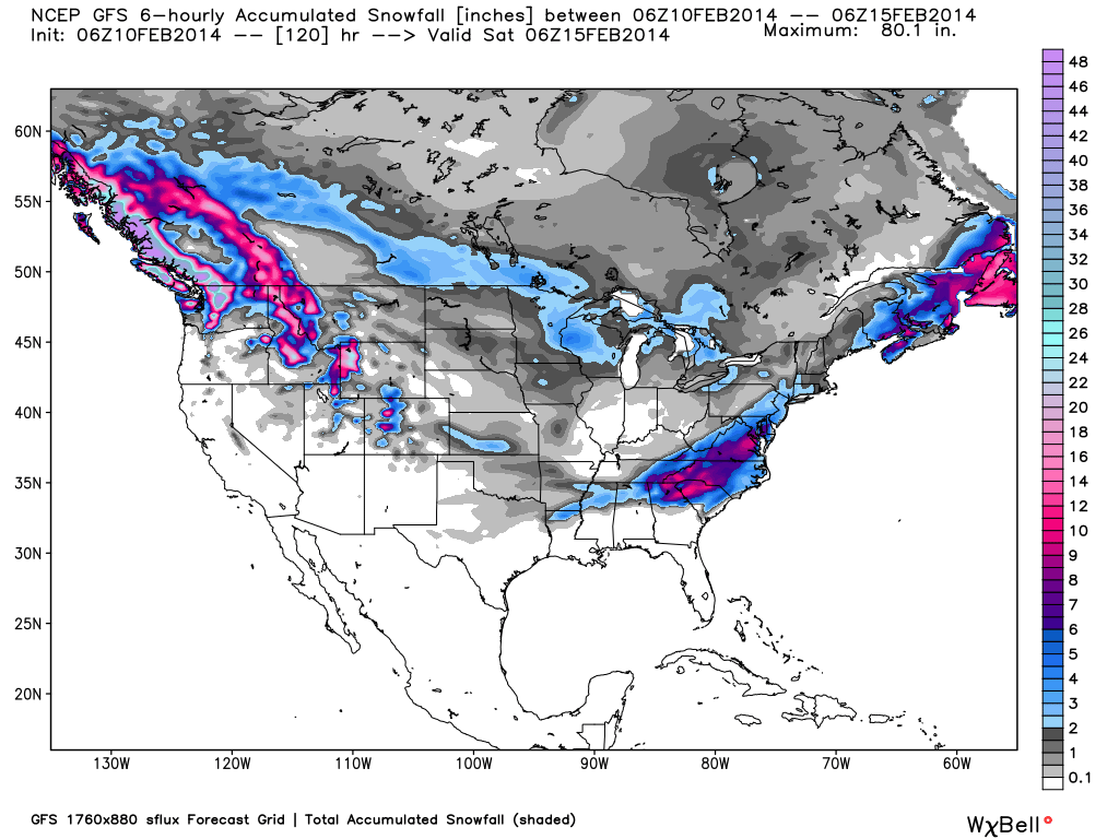
Total accumulated snowfall, according to the American GFS, through Friday night. Source: WeatherBell.com
What a past weekend it was for many areas of the Lake Tahoe region! Most areas received between 3-5 feet and though their snowpack still remains well below average, this storm was a blessing for the drought strickened areas of Northern California. For this week, Lake Tahoe will see snow taper off on Monday as the storm track pushes north. Wednesday through Friday could see very light accumulations across the highly elevated peaks but it will be trace amounts at best. Brian will keep us informed throughout the week in The Tahoe Daily Snow.
The big story this week will be the Northwest where heavy snow accumulations look to take aim throughout the entire week. This week's snow will be enhanced by the jet stream as it begins to retreat north beginning on Monday. The ski areas of Washington, British Columbia, Idaho, Western Montana, and Wyoming will see significant accumulations. Our Northwest Meteorologist Larry Schick is calling for Wednesday through Friday to be great days for powder skiing with Friday set to be the best. Click over to The Northwest Daily Snow for the latest details throughout the week.
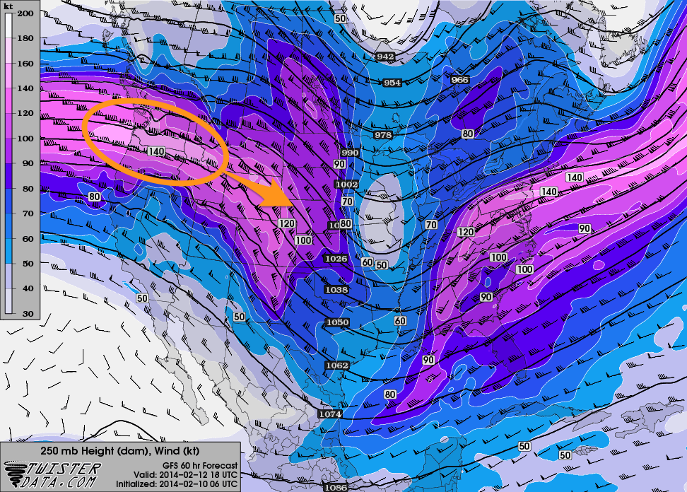
The winds at approximately 30,000 feet will move north this week igniting deep snow accumulations through Friday. Source: TwisterData.com, analysis by OpenSnow.
As the primary storm track pushes north this week, Utah and Colorado will see on and off snow showers Wednesday through Friday. Look for the northern most mountains to receive the highest totals throughout the week. The temperatures will once again be slightly warmer so look for a heavier snow similar to this past weekend. Abundant Pacific moisture will be in tow so locally heavier amounts for the northern mountains won't come as a surprise. Evan and Joel will have all the details in the Utah and Colorado Daily Snow.
We now turn to the Mid-Atlantic and Northeast where a coastal system is set to push through beginning on Wednesday. The difficult aspect of this storm will be forecasting how far inland the system decides to push. This will make a big difference in terms of rain and snow. This system looks to primarily effect the Mid-Atlantic but if it pushes farther in off the coast, New England could benefit as well. The models are still in disagreement so we will turn to our local forecasters, Justin and Brian in the Mid-Atlantic and New England Daily Snow, for the details as better agreement is found.
As for the Upper Midwest, snow showers look to be on and off throughout the week with higher totals taking place beginning on Thursday. All areas look to join in on the fun so turn to Andrew in The Upper Midwest Daily Snow for the latest details.
When you're up on the hill this week post pictures and updates using "LiveSnow", one of the features of our FREE iPhone and Android app.
Always check our Powder Finder and the forecasts for each mountain throughout the week for more details.
Sam Collentine | OpenSnow
PS - Want a ruler sticker? Go to your settings page and update your mail address so we can send you one.
About The Author
Sam Collentine
Meteorologist
Sam Collentine is the Chief Operating Officer of OpenSnow and lives in Basalt, Colorado. Before joining OpenSnow, he studied Atmospheric Science at the University of Colorado, spent time at Channel 7 News in Denver, and at the National Weather Service in Boulder.
Free OpenSnow App


